Roz Pidcock
02.05.2014 | 4:00pmKnowing how much carbon is contained in the world’s forests is important for keeping track of efforts to halt deforestation – a big contributor to greenhouse gas warming. But the data scientists usually use to measure forest carbon gives a poor picture of what’s really going on, researchers explained at the European Geosciences Union conference this week.
In the Congo, existing calculations of carbon stocks overestimate ground measurements by about 25 per cent, according to new research. And that’s not the only example. A recent paper in the journal Global Ecology and Biogeography describes a similar story for estimating carbon stocks in the Amazon using data from satellites.
This could be leading to sizeable errors in nations’ estimates of the state of their forests, the team led by Dr Edward Mitchard from the University of Edinburgh concludes.
Locking up carbon
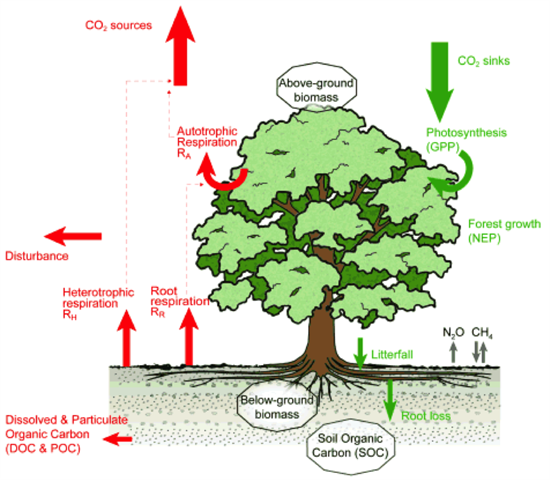
Trees absorb carbon dioxide as they grow, turning it into carbon-rich organic material through a process known as photosynthesis. Living vegetation stores carbon, until it is returned to the environment through burning or decay as part of the natural carbon cycle.
Source: Forestry Commission
When trees are cut down for fuel or to clear land – a process known as deforestation – the land soaks up less carbon. Since this increases the amount of carbon in the atmosphere, the effect of deforestation is expressed in terms of an emission.
Emissions from deforestation contribute to global warming. Deforestation – along with other changes in land use – is responsible for 180 billion tonnes of extra carbon in the atmosphere since 1750, a recent Intergovernmental Panel on Climate Change (IPCC) report concluded.
That’s about half as much carbon as emissions from fossil fuels and cement production combined, and a third of the total emissions from human activity, the report notes.
Slowing deforestation
But international efforts to reduce deforestation and forest degradation are having an impact. So much so that emissions from deforestation and land use have come down recently, the IPCC concludes.
That’s good news – but scientists still need to know how much carbon is locked up in the trees to accurately monitor any changes. Schemes like the United Nations collaborative initiative on Reducing Emissions from Deforestation and forest Degradation (REDD) programme are based on issuing payments to nations in return for conserving their forests. So it’s important to be confident of the size of the current carbon stocks – and any changes to those stocks.
Satellite measurements
Until recently, satellites have been the method of choice for measuring forest carbon. Satellites are a good way of seeing a very large area all at the same time.
The Ice, Cloud and Land Elevation Satellite (ICESat) takes millions of measurements of tree height using three lasers and converts them to an estimate of living plant material using regional, or even global, averages of tree density and species.
But satellites can’t measure the amount of vegetation directly, which is what scientists need to accurately estimate the amount of carbon contained in the forest.
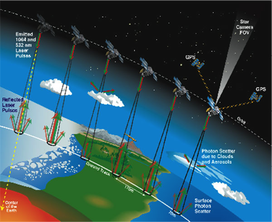
NASA’s Ice, Cloud and Land Elevation Satellite (ICESat) orbits the Earth every 100 minutes firing laser pulses to measure the height of objects on the land, sea and in the air. Credit: NASA
The ICESat’s measurements lead to a very general estimate of forest carbon stocks that mask important differences across the forest or between different regions, the Mitchard et al. paper explains.
In the new study, the scientists recorded tree species, height and diameters at 413 field stations in nine different countries across the Amazon basin. They then used a method called “kriging” – a data processing tool which allows the region in between stations to be mapped.
Carbon accounting
Both satellite and field methods produce maps of vegetation, known as above-ground biomass. The image on the right below shows the on-the-ground method. The left and middle images are two different satellite pictures of the same region (the yellow parts are outside of the area covered by the field data).
The two satellite pictures are quite different. The researchers explain this highlights another difficulty – remotely sensed estimates often don’t even agree with each other.
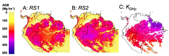
When the team compared the maps, they found the satellite images did a poor job of reproducing the patterns the scientists know exist in the Amazon, patterns which the ground method picked up. The paper says:
“The two remotely sensed carbon maps fail to capture the main gradient in Amazon forest carbon â?¦ from the densely wooded tall forests of the north-east, to the light-wooded shorter forests of the south-west”.
Failing to account for these differences means that one satellite image overestimated above-ground biomass by about 25 per cent, while the other underestimated it by the same margin.
“Ground-truthing”
Since the satellite images above are used to provide baseline data for RED++, differences of this magnitude may lead to significant errors, the study concludes. On the other hand, ground measurements can’t do the job on their own. The authors explain:
“[G]round plots will only ever be able to sample a very small percentage of the total area, and due to access difficulties, a network of ground points will normally be biased towards more easily accessible regions (concentrated near rivers, roads and scientific field stations).”
So what does the team suggest? Carbon mapping using satellite data needs to be “ground-truthed” using field measurements to account for regional variations in tree species and wood density. This raises its own challenges, say the researchers. Namely, the need to maintain and improve vast networks of field measurements right across the tropics.
For example, in other research presented at the EGU conference, a team led by Simon Lewis from Leeds University estimate the forests of Central Africa’s Congo Basin contain about 50 per cent more carbon per unit area than the Amazon forest. But estimates are limited by poor data.