Guest post: How Arctic warming could have steered Hurricane Florence towards the US
Prof Jennifer Francis is a research professor in the Department of Marine and Coastal Sciences at Rutgers University in New Jersey, US. Jennifer is a part of the Arctic Basecamp consortium that aims to communicate Arctic science to a wider audience.
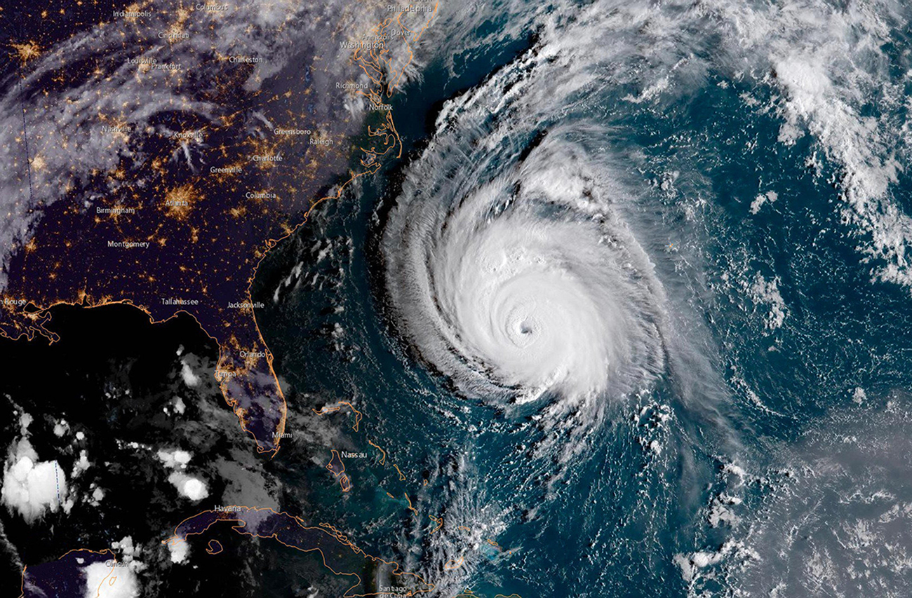
At around 7:15am local time on Friday 14 September, Hurricane Florence made landfall near Wrightsville Beach in North Carolina. The storm, which had been as strong as category 4 on the Saffir–Simpson scale during the past week, was downgraded to category 1 just before it hit the US coastline. Florence weakened further to a tropical storm and then a tropical depression, but she continued to wreak havoc in North and South Carolina.
NEW: #Hurricane #Florence has made landfall near Wrightsville Beach, North Carolina at 7:15 AM EDT (1115 UTC) with estimated maximum winds of 90 mph (150 km/h), and a minimum central pressure estimate of 958 mb (28.29"). https://t.co/tW4KeGdBFb pic.twitter.com/vzpe6MjTf9
— National Hurricane Center (@NHC_Atlantic) September 14, 2018
Although a category 1 hurricane still brings sustained winds of up to 95 miles per hour, Florence’s potency was not primarily due to her wind power.
Her threat comes mainly from water: torrential rain plus the bulge of a storm surge – where a low-pressure storm weather system pulls up the surface of the ocean – which she has built up along with her unusually slow crawl along the US coast last week.
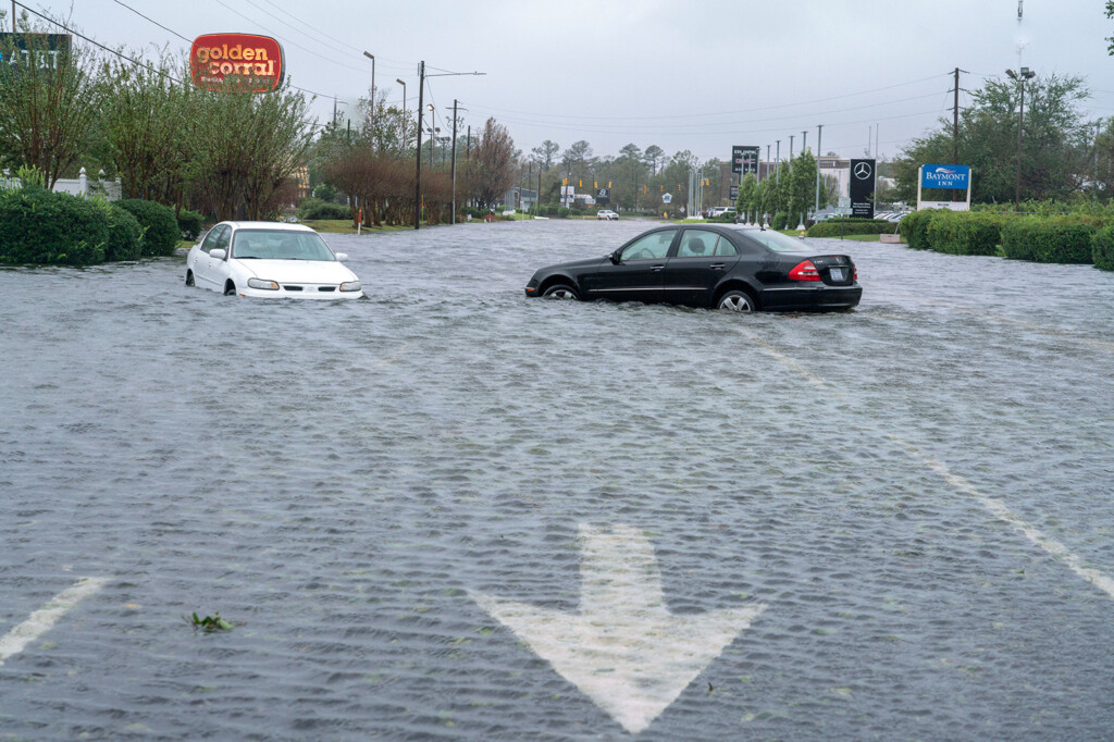
Raised ocean levels block the escape of rainwater through the river system and out into the sea. Combined with the “epic” amounts of rain that Florence unloaded in the Carolinas – measuring as much as one metre in some areas – this provides the ingredients for devastating flooding.
Rain from #Florence these next few days will cause flooding in many parts of the Carolinas. Expect flash flooding at any time and stay off the roads. Do NOT walk, swim or drive through floodwaters! https://t.co/KI7H0Mfs5Z
— FEMA (@fema) September 15, 2018
So far, more than 900 people have been rescued from rising floodwaters and 15,000 are still in shelters in North Carolina alone. The city of Wilmington has been entirely cut off from the rest of the state because of flooding. Yet some rivers have not yet hit their peak flows.
What has caused Florence to hit land in the US in this way is an increasingly common weather phenomenon called “blocking highs” in the North Atlantic. And these weather patterns may be linked to a warming, melting Arctic.
Blocking weather patterns
As their name suggests, a high-pressure “block” parks in one location for days or weeks, deflecting other weather systems around it. In summer, they are typically associated with bringing lengthy heatwaves and, in winter, with extended periods of cold.
But they can also affect the path of hurricanes, sometimes steering them on unusual tracks. Both Florence and Hurricane Sandy in 2012 were steered by blocking highs that propelled them westward at abnormally far northern latitudes rather than on a more typical curved path northward along the west Atlantic then toward Europe.
The science of blocking highs – what causes them to form and break up, and whether they are becoming more or less numerous – is widely debated and investigated.
Numerical weather prediction models often struggle to predict them and most climate models underestimate how often they occur. Measurements of the real world tell us that they are occurring more frequently in the North Atlantic during summer months.
However, it is tricky to tease out the cause – or causes – of blocking events. The trend of blocking highs is consistent with our predictions in a world with rapid Arctic warming. This tends to weaken the strength of the jet stream – a band of fast-flowing westerly winds high up in the atmosphere – because of a smaller temperature difference between the Arctic and the mid-latitudes.
A weaker jet stream tends to take a more “wavy” path. As the jet stream bulges, forming large northward excursions (called “ridges”), blocking highs can form at either side.
Added to this, we have been observing much warmer than normal ocean temperatures off the east coast of North America in recent years. This warm water also helps form stronger ridges and, thus, makes blocking highs more likely. A similar pattern was seen in the “Ridiculously Resilient Ridge”, a huge high-pressure weather system over the northeastern Pacific Ocean that caused California’s recent multi-year drought.
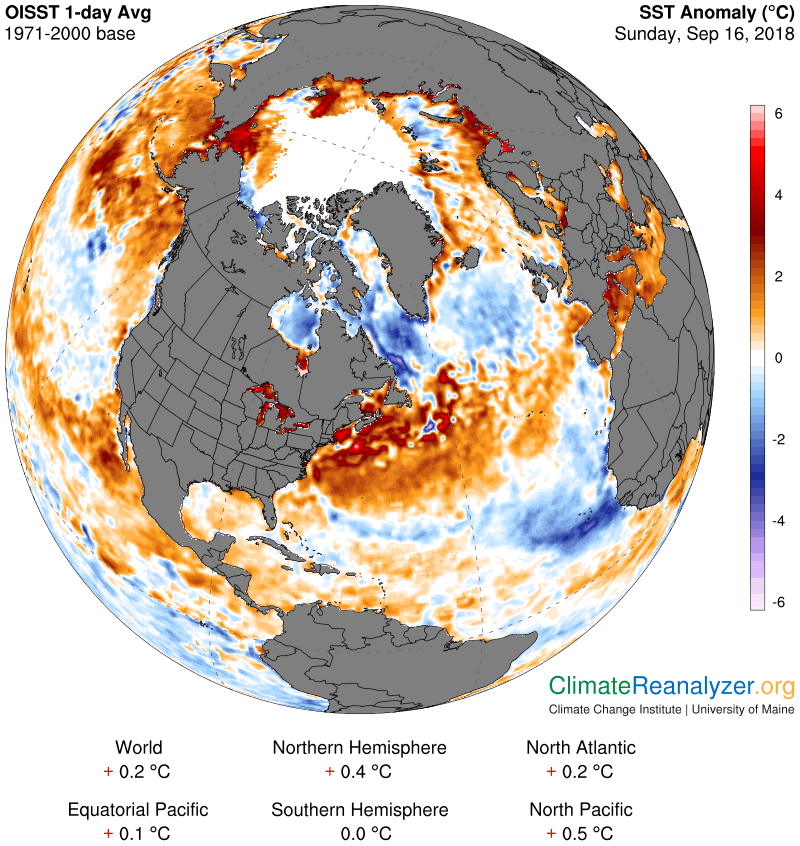
Arctic warming is not the only factor that favours a wavier jet stream; new research suggests that the influx of freshwater from the faster melt of Greenland’s ice sheet, melting sea ice and stronger river flow into the Arctic Ocean may be creating a “cold pool” in the North Atlantic.
This pool is believed to be impeding the flow of warm, salty Gulf Stream waters – which flow northwards across the Atlantic Ocean from the Gulf of Mexico up towards Europe – like a backed-up sewer pipe. This also contributes to the abnormally warm temperatures in the western North Atlantic and may be fueling stronger ridges, causing an Arctic warming “double whammy”.
Stuck storms
Not only may Arctic warming be helping to steer Florence on an unprecedented path as compared with previous storms with a similar formation history, she is also carrying more moisture – owing to enhanced evaporation from a warmer ocean – and travelling more slowly.
Her loitering over the Carolinas causes persistent, flooding rains, much like the situation when Hurricane Harvey got stuck near Houston, Texas, last summer. Research has since shown that climate change tripled the chances of the record rain that descended on Texas.
These more persistent weather patterns have been echoed across the northern hemisphere during 2018 – from prolonged cold spells and parades of coastal storms during winter, to heatwaves and droughts this summer – and now into hurricane season.
Several new studies have found evidence for more persistent summer weather patterns over northern hemisphere continents, along with a mechanism to explain this behaviour. A 2017 paper in Scientific Reports, for example, described a “fingerprint” of the conditions that lead to this stagnation, which basically consists of a “double peak” in the north-south temperature gradient.
Before human-caused warming, if you travelled from south to north on a continent, you would generally expect to experience a gradual cooling. With the “fingerprint” pattern, after starting out experiencing cooling, you then encounter abnormal warming along the northern belt of the continent, followed by cooling again. This double peak in the temperature tends to drive the splitting of the jet stream, with a branch flowing west to east along the north coast and another branch through the middle of the North America continent.
Between these branches the steering currents are very weak, so weather systems become stagnant – they get stuck, leading to prolonged heatwaves, droughts and rainy periods.
Florence stumbled into one of these weak-flow areas as it neared the coast, leading to prolonged heavy rains fuelled by overheated Atlantic water and evaporation. This is a similar pattern to Hurricane Sandy in 2012, where the storm stalled over the Caribbean with severe rainfall and resulting damage.
Declining snow cover
So, what causes this double peak in the temperature gradient? My hypothesis is that the answer lies in the ever-earlier loss of the spring snow cover in the high latitudes. This early melt allows the soil underneath to dry out and warm up much earlier in a belt along the high latitudes of the continents – yet another connection to rapid Arctic warming. Ongoing research will clarify the influence of this factor.
In short, much of the extreme weather that we have endured in recent years may be boosted by the warming, melting Arctic. Slowing these changes by reducing our carbon emissions will help soften the blow of climate change for generations to come.