Explainer: The polar vortex, climate change and the ‘Beast from the East’
Robert McSweeney
03.01.18Robert McSweeney
01.03.2018 | 4:44pmWhile much of Europe is shivering in subzero temperatures, the Arctic and eastern US have basked in unseasonably warm conditions in recent weeks.
Arctic temperatures during February hit record highs, including nine separate days where temperatures were above zero. This is more than 30C warmer than expected for an Arctic winter.
Numerous news reports have pointed the finger at the “polar vortex” for this unusual combination of weather extremes. Some have suggested that climate change is making these events more likely, driven by declining Arctic sea ice.
So what is the polar vortex? How does it affect mid-latitude weather? And what role – if any – is climate change playing?
‘Beast from the East’
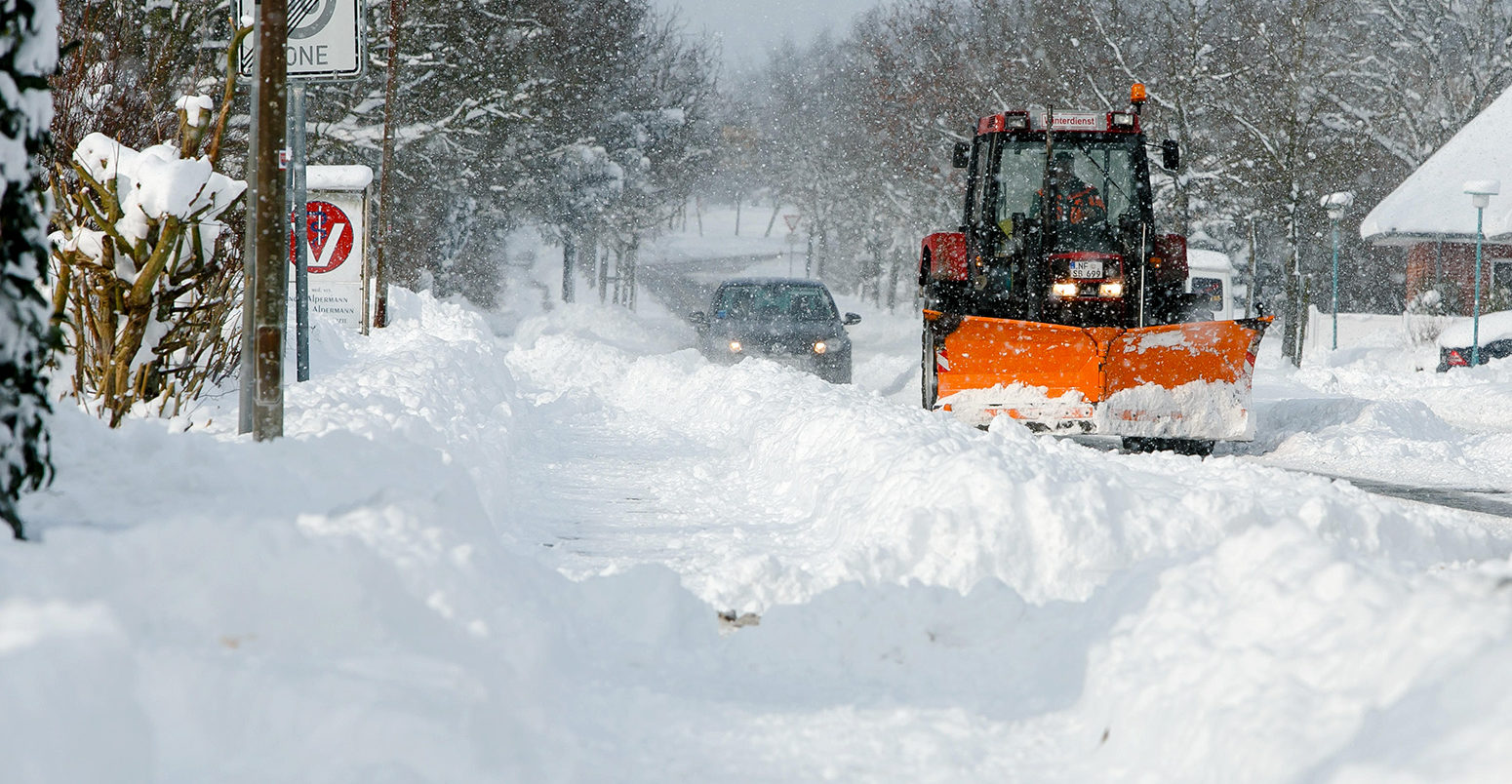
Many of the news headlines this week have been dominated by two sides of the same story. On one hand, the “Beast from the East” has swept across Europe, bringing freezing conditions and blizzards, leaving transport systems at a standstill in many countries.
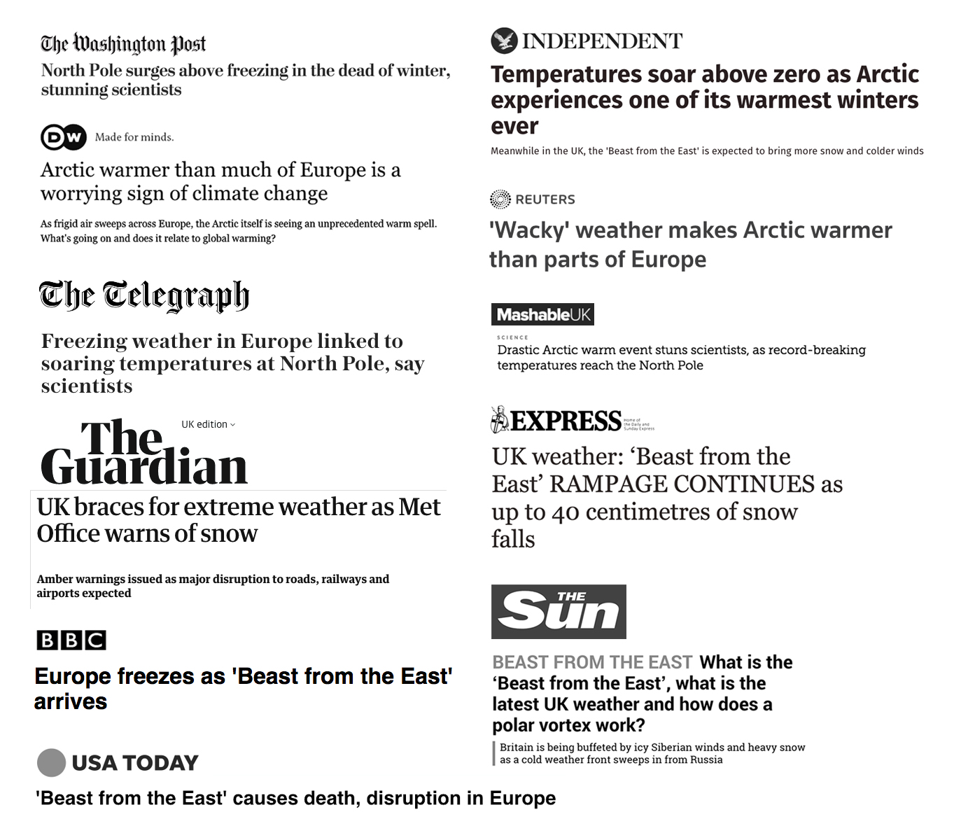
Selection of ‘Beast from the east’ headline coverage. Credit: Tom Prater, Carbon Brief
Temperatures across Germany tumbled to below -10C; homeless people in Brussels were detained overnight if they refused shelter; and roofs of dozens of houses collapsed under the weight of snow in Bosnia-Herzegovina. Snow even made a rare appearance in Rome.
On the other hand, a “warm air intrusion” has brought extraordinarily mild conditions to the Arctic.
Despite being in perpetual winter darkness, Arctic temperatures have soared in recent weeks. Siberia have been as much as 35C above average this month, reported the Guardian, while the northernmost tip of Greenland has already experienced 61 hours above freezing in 2018 – “more than three times as many hours as in any previous year”.
The extreme event continues to unfold in the high #Arctic today in response to a surge of moisture and "warmth"
2018 is well exceeding previous years (thin lines) for the month of February. 2018 is the red line. Average temperature is in white (https://t.co/kO5ufUWrKq) pic.twitter.com/cLeMxSxvWo
— Zack Labe (@ZLabe) February 25, 2018
These unusual weather extremes are two sides of the same coin. The culprit is a circulation pattern up in the stratosphere called the polar vortex, which has – temporarily – split into two, allowing warm air into the Arctic and pushing a blast of cold air over Europe.
The North Pole is warmer than much of Europe right now. pic.twitter.com/7hWpF0EysY
— Dr. Robert Rohde (@RARohde) February 26, 2018
But such warm Arctic conditions have concerned scientists. Cape Morris Jesup, Greenland’s most northerly point, “has been consistently and extraordinarily warm for the last week or so”, says Dr Ruth Mottram, a climate scientist at the Danish Meteorological Institute (DMI). She tells Carbon Brief:
“The DMI weather station recorded 10 consecutive days where the temperature was at least 0C or warmer for some or all of the day. This is the 3rd time in the record it has happened – the others were 2011 and 2017 – but the persistence of this weather event, as well as the magnitude of the warming is what has made it so unusual.”
The warming has also been boosted by foehn-effect winds, which have pushed ice away from the coast of Greenland and created open water, Mottram adds.
The warm Arctic conditions have seen sea ice melt when it is supposed to be growing through the winter. Arctic sea ice in January hit a new record low for the month, while InsideClimate News reported last week that “in just eight days in mid-February, nearly a third of the sea ice covering the Bering Sea off Alaska’s west coast disappeared”.
Brief stall in #Arctic sea ice extent growth in response to the anomalous weather conditions in the #Arctic. Total sea ice extent remains a record low for the date (satellite era – from 1979)…
Sea ice data from JAXA AMSR2 at https://t.co/qyOinXs8pR pic.twitter.com/eGkUe3R92Q
— Zack Labe (@ZLabe) February 26, 2018
Newspaper reports have speculated on the role that human-caused climate change could be playing – and whether the conditions are a sign of things to come. Wednesday’s Guardian, for example, led its frontpage with the headline, “Arctic heatwave triggers climate meltdown fears”.
But the potential link between the climate change, the polar vortex and mid-latitude weather is a complicated, uncertain and – at times – contentious one.
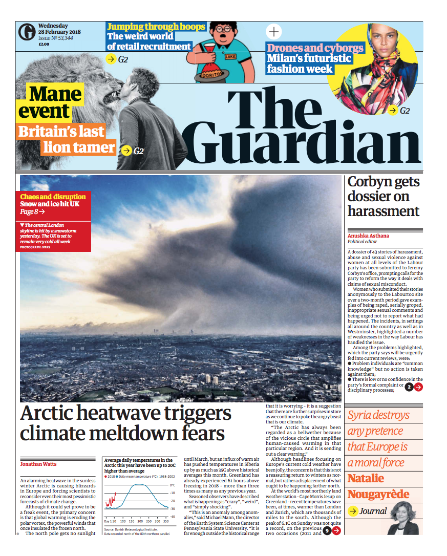
Front page from The Guardian, 28 February 2018
What is the polar vortex?
The term “polar vortex” is “perhaps an unfortunate use of words”, says Dr James Screen, assistant professor in climate science at the University of Exeter. He tells Carbon Brief:
“Most atmospheric scientists would say, I think, that the polar vortex is a specific feature of the wintertime stratospheric circulation (more fully, the stratospheric polar vortex). In recent times, the terminology has increasingly been used to describe the tropospheric circulation.”
That needs a bit of unpacking. The first thing to note is that the polar vortex is in the stratosphere, the layer of the atmosphere that starts at around 8km above the Earth’s surface at the poles.
The stratospheric polar vortex is a low-pressure weather system that sits over the Arctic (there is an equivalent one over the Antarctic). Its main feature is the strong west-to-east winds which encircle the north pole. These winds are known as the “polar night jet” because they only appear during the dark Arctic winter.
The polar night jet forms a boundary between the very cold Arctic air and the warmer air over the mid-latitudes.
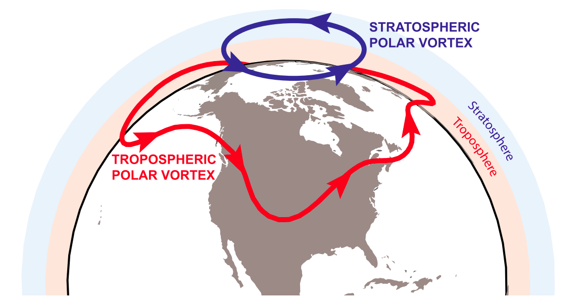
Illustration of the stratospheric (blue) and tropospheric (red) polar vortices. Source: Waugh et al. (2017). © American Meteorological Society. Used with permission.
As Screen pointed out earlier, the stratospheric polar vortex is often confused with a second vortex – this time in the troposphere.
The tropospheric polar vortex is a year-round feature of mid-latitude weather, driven by the temperature difference between the Arctic and the mid-latitudes. Its boundary winds are more commonly known as the jet stream. As seen in the illustration above, it is much larger than its namesake in the stratosphere.
The position and strength of the jet stream have a big impact on mid-latitude weather. When the jet stream is strong, its fast-flowing winds provides a barrier between the cold air over the Arctic and the milder air further south. When it weakens, the jet stream slows and can develop kinks. This allows the cold Arctic air to spill out into the mid-latitudes and for warmer air to spill in – as has been the case recently.
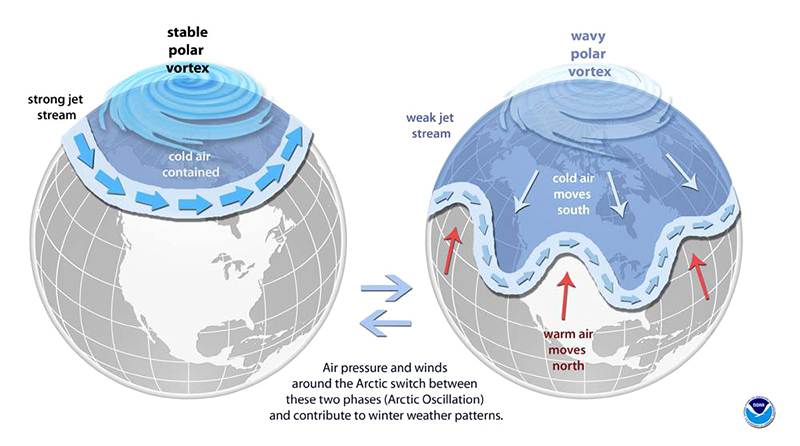
The science behind the polar vortex. Credit: NOAA
The strength and position of the jet stream can be gauged by a metric called the Arctic Oscillation (AO). When the AO is positive, the jet stream is strong. When it’s negative, the jet stream is weak.
The similar names and characteristics of the two polar vortices can cause confusion, says Screen:
“Typically, ‘polar vortex’ was reserved for the stratospheric, but now it seems ‘polar vortex’ is being used to essentially describe the jet stream”.
The distinction is important when it comes to talking about what has been happening to the weather this week and the potential impacts of climate change (more on that later).
Sudden stratospheric warming
The trigger for this week’s unusual weather started with a “sudden stratospheric warming” event.
Sudden stratospheric warming (SSW) occurs when something knocks the stratospheric polar vortex out of kilter. This can be caused by large weather patterns in the troposphere.
The resulting wobbles in the polar night jet can cause the circulation to slow down, reverse in direction and even split into two separate vortices. This allows air to collapse in over the Arctic, compressing the atmosphere and causing temperatures to rise dramatically in the stratosphere – by as much as 50C in just a couple of days.
When this happens, the knock-on impacts for the troposphere can mean the usual westerly winds that swirl around the mid-latitudes also reverse and become easterlies. This might take a few days or weeks to materialise.About two weeks ago, the stratospheric polar vortex weakened and then split into two. You can see this happen in the clip below. The fast-flowing winds shown by the purple lines wrench from neat single circle into two vortices swirling side-by-side.
The northern polar vortex tearing itself apart in the current #SSW – expect the northern hemisphere to be chilly for the next month or so! pic.twitter.com/271Xp6iOX2
— Simon Clark (@simonoxfphys) February 25, 2018
What is being seen now is consequence of the split, explains Mottram:
“This has allowed warmer air to move up into the high Arctic Ocean and, at the same time, the remnants of the high pressure are now lodged over Scandinavia, bringing cold air to northern Europe and the Labrador Sea – so southwest Greenland is actually very, very cold and [Greenland’s capital city] Nuuk will probably have a below-average temperature this month.”
This is a classic weather pattern that occurs throughout the observed record, says Mottram. However, this time around, the pattern has been deeper and longer than normal, prompting the question of whether climate change is playing a part – particularly as research has shown an increasing frequency and duration of Arctic “winter warming events”, where daily temperatures peak above -10C.
https://twitter.com/robertscribbler/status/968893197740101632
Mottram says scientists do not yet have enough data about these events to say for sure whether these conditions are related to climate change, or that they will occur more frequently. However, such a warm Arctic could have had a helping hand, Mottram adds:
“It’s probably safe to say, though, that the warming associated with this event has been boosted by climate change to an extent. We see these warming spikes all the way through the record, but the baseline is shifting upwards. The atmosphere is warmer and so is the ocean.”
However, as well as background warming, some researchers argue that the rapid decline in Arctic sea ice is making extreme mid-latitude weather more likely.
Arctic amplification
Temperatures in the Arctic are increasing around three times as fast as the global average – a phenomenon known as Arctic amplification.
One of the main reasons is the loss of sea ice in the region. As Arctic sea ice melts, energy from the sun that would have been reflected away is instead absorbed by the ocean.
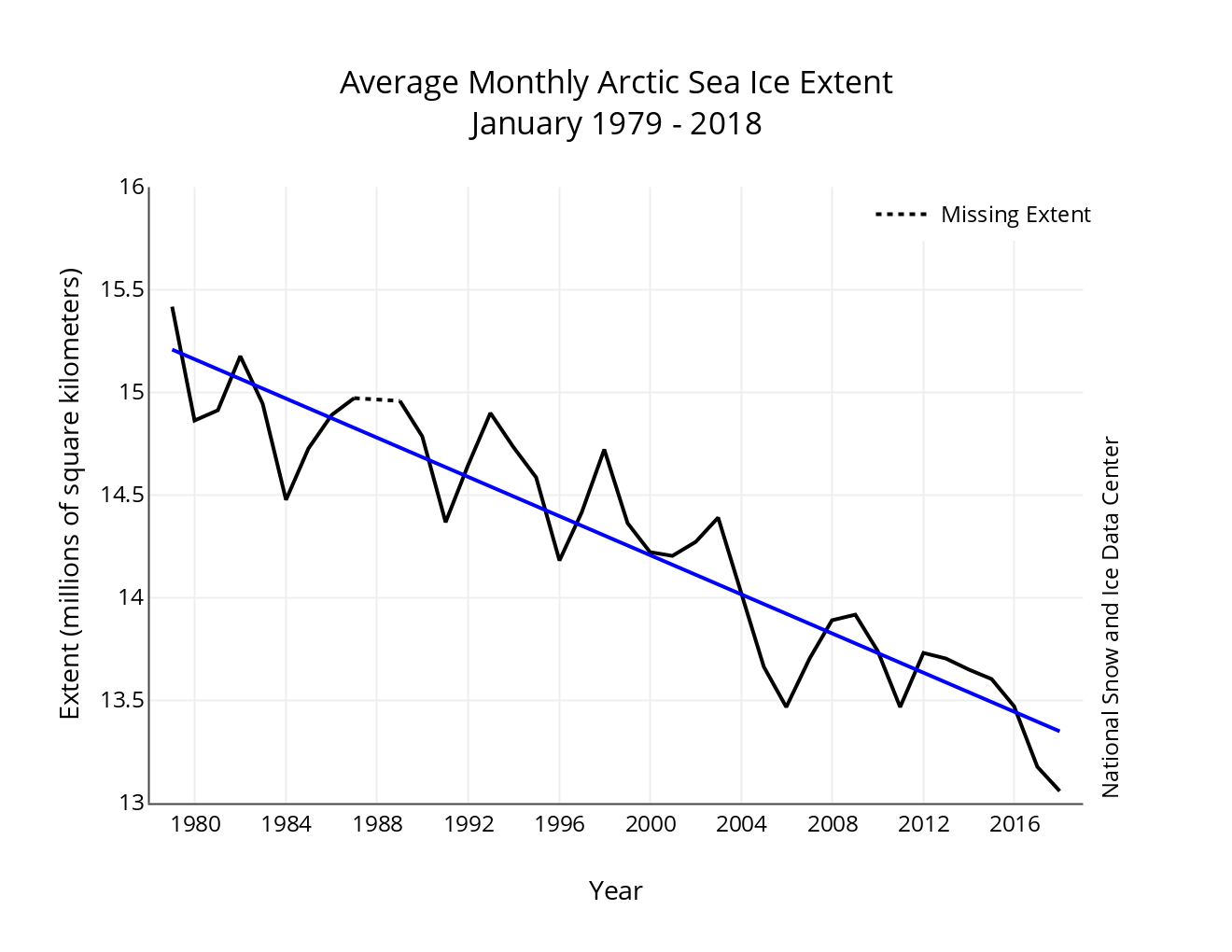
Monthly January Arctic sea ice extent for 1979 to 2018, showing a decline of 3.3% per decade. Note: the y-axis does not start at zero. Credit: NSIDC
The links between Arctic amplification and mid-latitude weather has become a prominent topic of climate research. Just last month, the journal Advances in Atmospheric Sciences published a special issue on the subject.
Scientists have put forward various mechanisms for how the two could be connected. For example, as the Arctic warms rapidly, the temperature difference between the Arctic and mid-latitudes declines. This could be weakening the jet stream, causing it to meander more and allow cold air to be pulled down to the mid-latitudes.
At the same time, some climate model projections suggest that while declining sea ice could amplify year-to-year variability in mid-latitude weather in the near-term, total variability will ultimately decrease under high emissions scenarios with major loss of summer sea ice.
The weakening of the stratospheric polar vortex is a possible route for Arctic amplification to influence mid-latitude weather, Screen explains:
“It has been argued that Arctic sea ice loss has weakened the polar stratospheric vortex and that this might make the negative AO [a weakened jet stream] and severe winters more likely.”
However, this theory is still “contentious”, he adds.
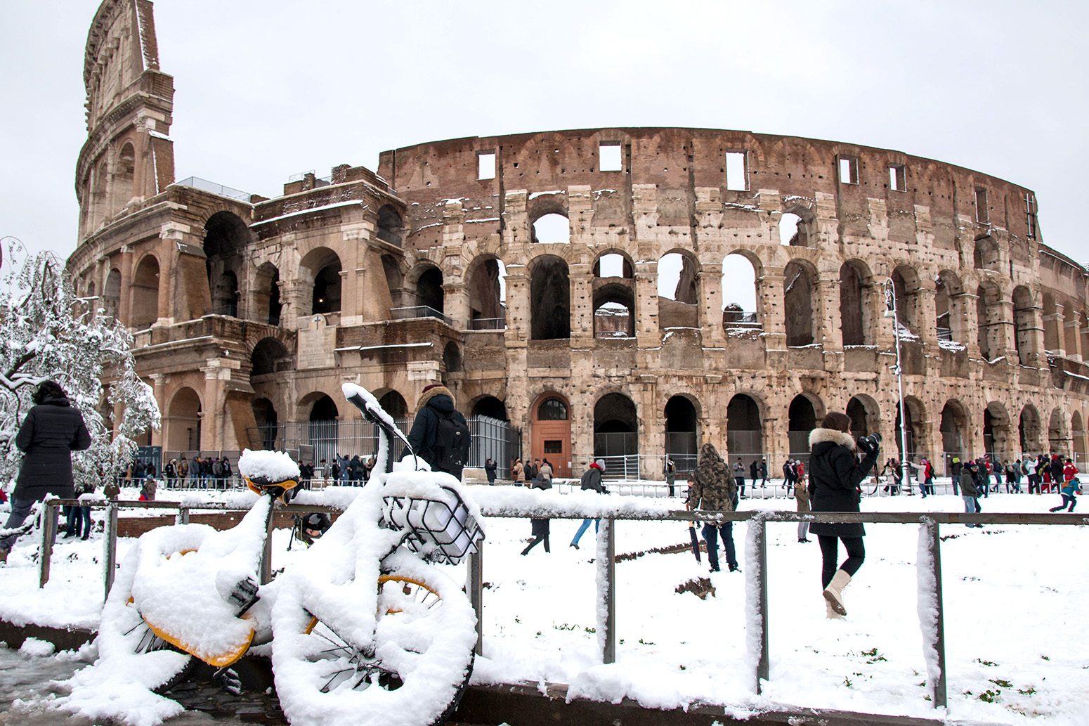
Roma, Italy. 26th Feb, 2018. People walk by the ancient Colosseum during a snowfall in Rome. Credit: CrowdSpark/Alamy Live News.
Other scientists are more certain. Prof Jennifer Francis, a research professor in the department of marine and coastal sciences at Rutgers University, tells Carbon Brief “there’s definitely a connection”:
“At least a dozen studies now have made the link between sea ice loss – especially in the Barents and Kara seas – to the jet stream into the stratospheric polar vortex and back to mid-latitude weather”.
The process starts with sea ice loss allowing Arctic waters to absorb more heat from the sun during summer, explains Francis. This warmth slows ice formation in the Barents and Kara seas in early winter.
There is usually a bulge in the jet stream over this region, says Francis. The warming creates an area of high pressure just to the east of the bulge, along with stronger cold winds from the Arctic going into central and eastern Asia, she explains:
“This effectively creates a larger north-south wave in the jet stream, which under the right conditions, transfers wave energy upward into the stratosphere. When large pulses of wave energy go into the stratospheric polar vortex, the vortex can be disrupted from its usual circular shape centered over the pole.”
This can, therefore, be the trigger for a sudden stratospheric warming event and, in turn, unusual weather in the mid-latitudes.
One of the studies that has made this link was published last month in the Bulletin of the American Meteorology Society (BAMS). Led by PhD researcher Marlene Kretschmer at the Potsdam Institute for Climate Impact Research (PIK), the study identifies seven different “states” that the stratospheric polar vortex displayed during winter (January-February) over 1979-2015.
Of these states, the frequency of a “weak distorted” vortex has increased from around three days per winter during 1979-96 to seven days during 1998-2015, the paper finds, while days of a “strong” vortex have declined from “from approximately 12 days per season to just six days”.
A weak vortex is usually “accompanied by subsequent cold extremes in midlatitude Eurasia”, the study notes.
In an earlier journal paper, Marlene Kretschmer’s research also identified sea ice cover in the Barents and Kara seas ice as “important external drivers” of mid-latitude weather patterns in winter.
But despite the flurry of work in this area, the “research in understanding the stratospheric pathway from Arctic Amplification and sea ice is still very young”, notes Zack Labe, a PhD candidate in climate science at the University of California at Irvine.
Indeed, there is “still significant research ongoing in understanding the dynamical relationships between stratosphere-troposphere interactions”, Labe tells Carbon Brief.
As such, for the time being, there is “not a clear consensus on how sea ice and Arctic amplification may affect the polar vortex”, he concludes.
Updated on 5 March 2018 to include the two studies led by PIK on the different states of the stratospheric polar vortex.
-
Explainer: The polar vortex, climate change and the ‘Beast from the East’