Atmosphere ‘has finally woken up’ as El Niño gets underway in the Pacific
Roz Pidcock
03.06.15Roz Pidcock
06.03.2015 | 2:55pmThe long-awaited El Niño has arrived. After keeping a close eye on evolving conditions in the Pacific, scientists yesterday announced the official onset of El Niño, a phenomenon affecting weather worldwide. But the nascent event is likely to have little global impact, scientists say.
The US National Oceanic and Atmospheric Administration (NOAA) Climate Prediction Centre upgraded its assessment from ‘El Niño Watch’ to ‘El Niño Advisory’, meaning an event is now occurring.
Scientists have classified the current event as a “borderline, weak El Niño” with a 50 to 60 per cent chance of persisting through Spring. Its weak strength and late timing mean “widespread or significant global impacts” are unlikely, yesterday’s report says.
An unsure start
Every five years or so, a change in the winds causes a shift to warmer than normal sea surface temperatures in the equatorial Pacific Ocean – known as El Niño. Together with its cooler counterpart, La Niña, this is known as the El Niño Southern Oscillation (ENSO) and is responsible for most of the fluctuations in global weather we see from one year to the next.
The official threshold for when the ocean passes into an El Niño state is when sea surface temperatures, averaged over three months, exceed 0.5 degrees Celsius in the central and eastern Pacific. The latest data for February show average sea surface temperatures 0.6 degrees above average, as the map below shows. (Click here for an animated version.)
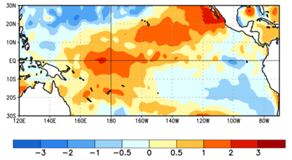
Average sea surface temperature in the tropical Pacific for the week of 25th Feb. Anomalies are relative to 1981-2010 weekly average. Source: NOAA Climate Prediction Centre
Normally, warmer water at the sea surface triggers a sequence of interactions between the atmosphere and ocean that amplifies the initial warming, and an El Niño builds.
Sea surface temperatures have been hovering at or around the critical point for several months, prompting predictions that El Niño was on its way as far back as last April.
But until this week, the atmosphere had “largely failed to respond” as expected, with leading experts dubbing El Niño’s failure to emerge as “puzzling” and “an enigma”.
Atmosphere reacts
Now, the atmosphere seems to have sprung into action, Prof Mat Collins, El Niño expert at the University of Exeter and joint Met Office Chair in climate change, tells Carbon Brief.
“It seems like the atmosphere has finally woken-up to the fact that the sea surface temperatures have been warm in the equatorial Pacific.”
The fledging El Niño classifies only as a weak event, with most models predicting a slow increase over the coming months. A blog by NOAA El Niño scientist Dr Emily Becker accompanying yesterday’s announcement, explains why this event is weaker than past ones:
“The current warm sea surface temperature anomalies are greatest in the Central Pacific. ENSO events centered in this area tend to be weaker”.
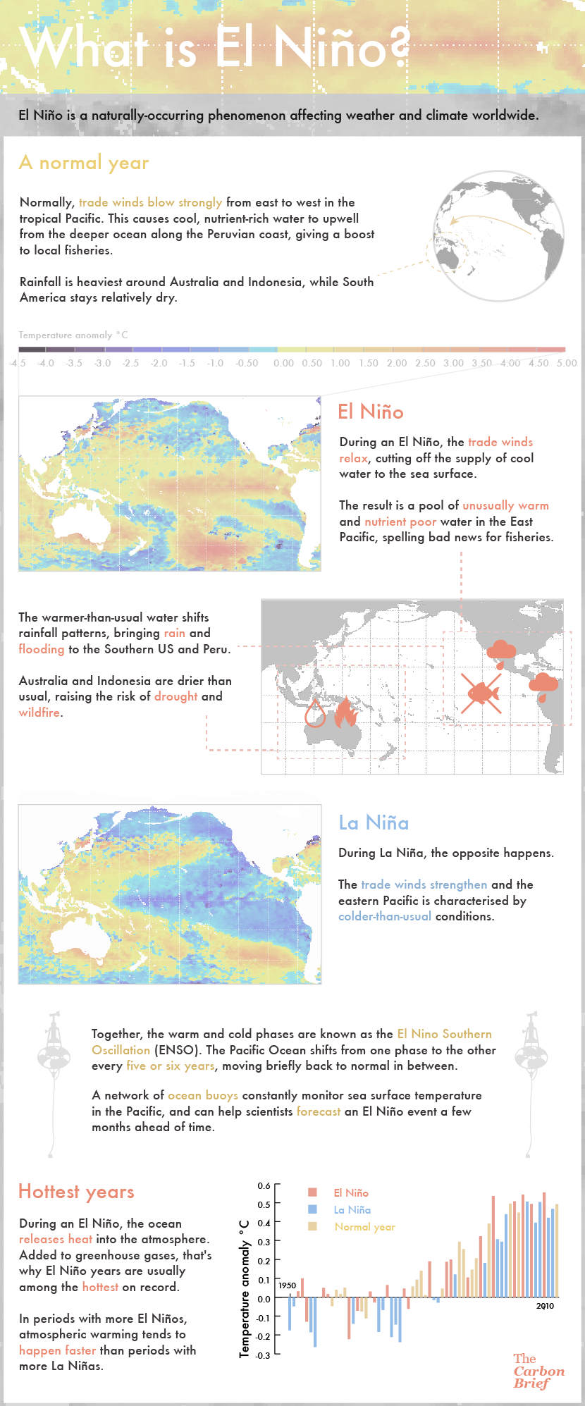
Infographic: What is El Nino? Credit: Rosamund Pearce/Carbon Brief.
A weak event
While El Niño’s initial elusiveness proved puzzling, the fact that it seems to be spinning up at this time of year is also unexpected, Collins explains:
“[T]his is usually a time in which we would expect to see an El Niño event decaying, so it would be a pretty weird event that amplified significantly now.”
Models’ ability to predict how an El Niño will evolve is notably reduced during April, May and June, when temperatures in the Pacific can change very quickly. This is what’s scientists call the “spring predictability barrier”.
Given these uncertainties, the NOAA scientists predict a 50 to 60 per cent chance of El Niño persisting through the Northern Hemisphere summer. The odds of it sticking around to September and beyond drop to 50 per cent.
Low impact
While the effects of El Niño may be felt in some locations during Spring, we’re unlikely to experience a worldwide impact, yesterday’s NOAA report says:
“Due to the expected weak strength, widespread or significant global impacts are not anticipated.”
View on YouTube Dr Jeff Masters from Weather Underground and Dr Kevin Trenberth explaining how ENSO affects global temperature trends by reorganising heat between the atmosphere and ocean. Credit: Peter Sinclair, Climatecrocks.com
The influence of El Niño outside the tropics are also typically weak at this time of year. Becker explains:
“After twelve months of El Niño Watches, we are issuing an El Niño Advisory. However, what it really represents is an incremental crossing of the borderline â?¦ From an impacts perspective, this is not particularly momentous”.
On the question of whether El Niño will bring much-needed rain to drought-ridden parts of California, Becker doesn’t hold much hope. She says:
“Especially since the rainy season in the West is winding down by March, it is unlikely that these current El Niño conditions will lead to substantial, drought-breaking rains.”
Given El Niño’s somewhat unpredictable and elusive behaviour so far, its next moves will be of great interest to scientists worldwide. We await the next update in a month’s time, on 9th April.
Main image: El Niño diagram preview.
-
Atmosphere 'has finally woken up' as El Niño gets underway in the Pacific