99% of Mount Everest glaciers could be gone by 2100
Robert McSweeney
05.27.15A region of the Himalayan mountain range, home to the iconic peak of Mount Everest, could be almost completely free of glaciers by the end of the century, a new study shows.
And the findings may illustrate what could happen to glaciers across eastern and southern parts of the Himalayas, the lead author tells Carbon Brief.
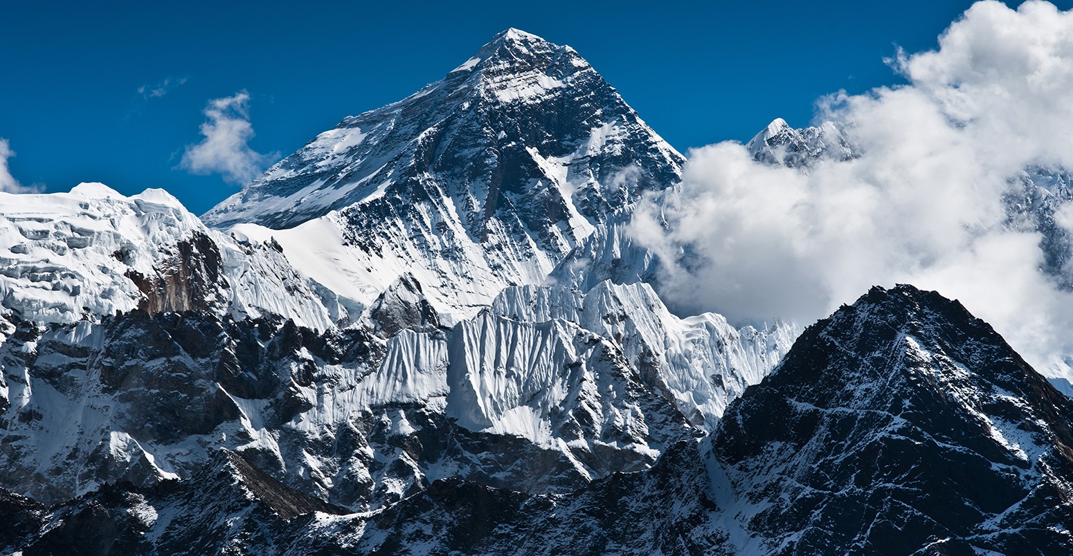
Mount Everest
The Dudh Koshi river basin sits in central Nepal. It’s home to some of the world’s tallest mountains, including Mount Everest itself, and is one of the most popular climbing and tourist destinations in Nepal.
Around 410 square kilometers of the area is covered in glaciers, huge rivers of ice formed from snow compacted over many years. In this part of Nepal, these are monsoon-type glaciers, which both lose ice through melting and gain it through snowfall during the summer monsoon season.
In a new study, published in The Cryosphere, researchers use past measurements of the glaciers to develop a model to analyse how they have changed and could change in the future as global temperatures rise.
The graph below shows the model simulations of changes in glacier ice in the basin. Between 1961 and 2007, the volume of ice has decreased by around 16%, while the area covered by glaciers has decreased by 20%.
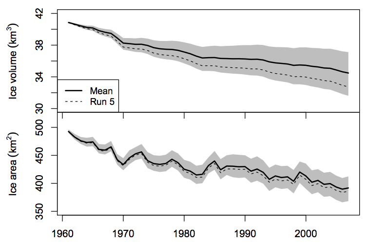
Graphs show average winter ice volume (top panel) and ice mass (bottom panel) for 1961-2007. Black line shows average from 20 model runs and grey shading shows the range from the minimum to the maximum model results. Source: Shea et al. (2015).
Emissions scenarios
To assess how the glaciers could be affected by climate change, the researchers incorporated two emissions scenarios and the output of four climate models into their glacier model – creating eight potential future climates.
The emissions scenarios are two of those adopted by the Intergovernmental Panel on Climate Change ( IPCC): RCP4.5, where emissions stabilise around the 2050s, and RCP8.5, the scenario with the highest emissions of those the IPCC uses.
You can see the projected changes from their results in the graph below, where blue lines show model simulations using the RCP4.5 emissions scenario, and the red lines show those using RCP8.5.
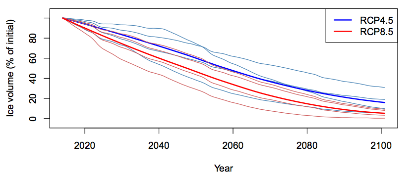
Projected loss of glacier volume through the 21st century for RCP4.5 (blue lines) and RCP8.5 (red lines) emissions scenarios. Thin lines show individual model results and bold lines show average across all models. Source: Shea et al. (2015).
The average change across their model projections suggests ice volume of the region’s glaciers could shrink 39-52% by 2050 and 84-95% by 2100. One model run shows a near-complete melting of all the region’s glaciers by the end of the century.
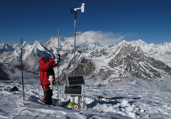
Taking measurements in the Mera Glacier region of the Dudh Kosi basin, Credit: Patrick Wagnon.
Rising snow line
The results suggest the glaciers in the basin are highly sensitive to temperature changes, lead author Dr Joseph Shea, a glacier hydrologist from the International Centre for Integrated Mountain Development (ICIMOD) in Nepal, tells Carbon Brief.
Warmer temperatures not only cause the glaciers to melt, but also mean precipitation is more likely to fall as rain instead of snow, so the melted ice isn’t replenished.
The height of the glaciers in the region is a particular factor, Shea says:
We think the sensitivity to temperature is due mainly to the fact that most glaciers are located between 5000m and 6000m in the basin.
At the moment, the glaciers tend to be above the freezing level – the line at which the average monthly temperature is zero degrees. This snow line currently moves from around 3,200m and 5,500m between winter to summer each year, the researchers say. But as temperatures warm, it is likely to rise by 800-1,200m by 2100, leaving more glaciers below the line and at risk from above-zero temperatures, the study says:
A potential snow line elevation of 7,000m in August would expose 90% of the current glacierized area to melt and severely restrict snow accumulation during the monsoon.
The figure below shows the largest reductions in glacier ice are expected to occur at 5,000-6,000m of elevation. The top (bottom) graphs show projected changes in glacier area at different elevations under a moderate (high) emissions scenario for each decade of the 21st century. In the high emissions model simulations in graph C, glaciers below 6,500m are “essentially eliminated by 2100” (yellow line).
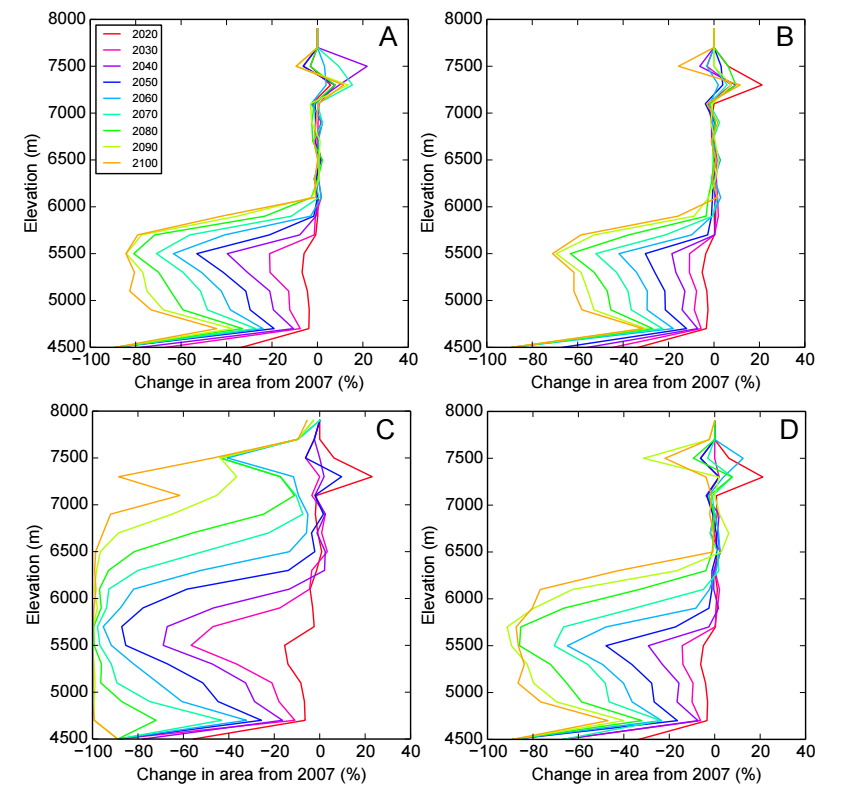
Projected percentage change in glacier area by elevation for each decade of the 21st century. Graphs show A) moderate emissions, MIROC-ESM model, B) moderate emissions, MRI-CGCM3 model, C) high emissions, IPSL-CM5a_LR model, and D) high emissions, CSIRO-MK3-60. Source: Shea et al. (2015).
Proglacial lakes
Meltwater from glaciers is an important source of water for much of the Himalayas, particularly during the dry season, the researchers say.
Substantial losses of the glaciers would have a large impact on availability of water for general use, agriculture and hydropower, the paper says. The river basin is a major contributor to the Koshi River, for example, which accounts for almost a quarter of the potential for hydropower in Nepal.
Melting glaciers could also increase the risks of flood events for communities downstream, the paper says.
Around a quarter of the glaciers in the region are considered ‘debris-covered’, which means they’re coated by anything from fine silts and dust up to rocks and boulders.
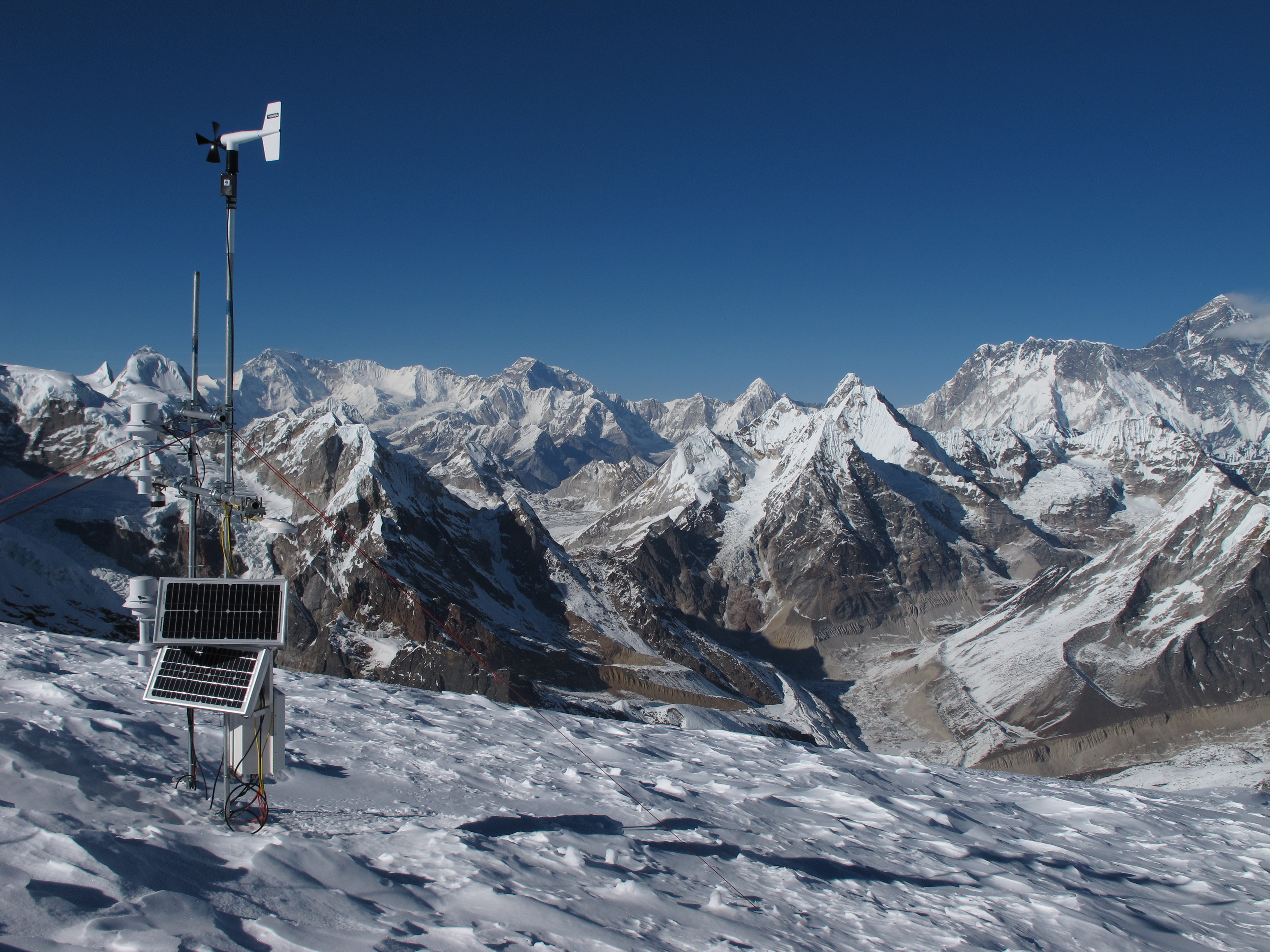
Instruments used to study the Mera Glacier region of the Dudh Kosi basin, Credit: Patrick Wagnon.
When debris-laden glaciers melt, they can leave behind a lake of meltwater held back by a precarious dam of rocks and silt. These proglacial lakes are vulnerable to bursting at any time and can release a large flood downstream, says Shea.
The river basin has seen 15 proglacial lakes burst in the last 50 years, the researchers say, and more lakes could form as the glaciers melt.
The study suggests the region could be highly sensitive to climate change, the researchers conclude. And Shea says it could provide an indication of what could happen to other monsoon-type glaciers in the eastern and southern Himalayas.
Main image: Mount Everest Peak at 8848m.
Shea, J.M. et al. (2015) Modelling glacier change in the Everest region, Nepal Himalaya, The Cryosphere, doi:10.5194/tc-9-1-2015