First look at new NASA satellite map reveals global carbon dioxide hotspots
Roz Pidcock
12.18.14Roz Pidcock
18.12.2014 | 8:10pmNASA space scientists today unveiled a new satellite map showing carbon dioxide levels in the atmosphere right across the globe.
The map is the first two months of data from the new Orbiting Carbon Observatory-2 (OCO-2) mission, launched in July this year.
The team from NASA’s Jet Propulsion Laboratory, Colorado State University and California Institute of Technology presented their findings at AGU conference in San Francisco today.
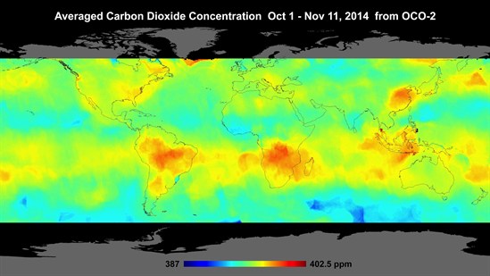
The map shows an average global concentration of 400 parts per million (ppm) with hotspots of high carbon dioxide in the Southern Hemisphere above southern Africa and Brazil. The scientists attribute this to springtime burning of savannas and forests and clearing land for farming.
Sources and sinks of carbon dioxide vary seasonally so scientists need at least a year of data to see where carbon dioxide is being released and where it’s absorbed, the scientists note.
Changes in carbon dioxide over time can help better understand the processes cycling carbon between the atmosphere, land and oceans, says Deputy project leader AnnMarie Eldering:
“[These measurements] could lead to an improved understanding of the relative importance in these regions of photosynthesis in tropical plants, which removes carbon dioxide from the atmosphere, and biomass burning, which releases carbon dioxide to the atmosphere.”
The satellite also measures the amount of chlorophyll in plants, the pigment used to capture sunlight as they photosynthesise and grow. NASA scientist Christian Frankenberg explains:
“[This] complements the OCO-2’s carbon dioxide data with information on when and where plants are drawing carbon from the atmosphere”.
At the moment, the OCO-2 satellite isn’t geared up to measure carbon dioxide over small areas, such as cities or industrial areas. But a planned mission aboard the International Space Station could begin providing that information by 2018, Eldering told journalists.