Guest post: Discovering a potential ‘tipping point’ for Congo’s tropical peatland
The world’s largest tropical peatland complex lies in the centre of Africa’s Congo basin.
First mapped by my research team in 2017, we estimate that there are 16.7m hectares of peatland, containing 29bn tonnes of carbon. This is 28% of the Earth’s entire tropical peat carbon stock.
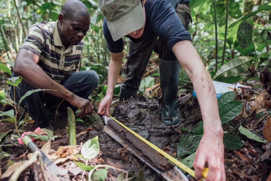
Peat is partly decomposed plant matter, which builds up when decomposition is incomplete – usually because the soil is waterlogged. In our latest study, published in Nature, we extracted a six-metre “core” down through the peat beneath a very remote peat swamp forest in the Republic of the Congo.
Analysing this core has given us a picture of how the peatlands built up over thousands of years and reveals a remarkable discovery. A period of dry conditions thousands of years ago caused the peat to decompose, likely releasing their long-held carbon into the atmosphere.
The findings highlight the vulnerability of the central Congo peatlands to drought and show that they lie close to a “tipping point” where billions of tonnes of carbon could be released into the atmosphere, accelerating climate change.
A ghost interval
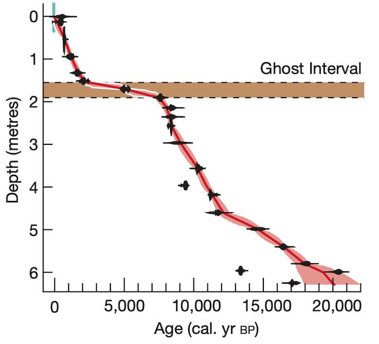
Using radiocarbon dating, we discovered that peat began to form at least 17,500 years ago. However, the rate of peat formation was far from constant. After an initial period of fast peat accumulation, almost no peat built up from about 7,500 years ago until 2,000 years ago.
We call this period – which contains an average of less than 0.1mm of peat per year – a “ghost interval”. Fast peat accumulation then resumed for the next 2,000 years. This is highlighted in the figure below, which shows the age of the peat from radiocarbon dating (x axis) through the depth of the core (y axis).
So, what happened? Did the peat stop forming due to a big change in the vegetation, which led to lower inputs of plant matter and so less peat? Or did decomposition speed up? Or did the peat get removed another way, such as a huge fire burning away layers of peat?
Three lines of evidence point to greater decomposition. First, pollen grains preserved in the peat showed there was consistently a tropical forest overlying the peat during the ghost interval, meaning there were no big changes in plant matter inputs.
Second, there was no evidence of fires during the ghost interval, nor any other human impacts.
Finally, the peat present in the ghost interval is much more decomposed compared to the peat found before or after it. Indeed, the peat in the ghost interval is so decomposed it chemically resembles lignite – a type of soft, brown coal.
A past drying climate in central Africa
Samples from the peat core also helped answer the question of what caused the peat to decompose.
Along with pollen grains, the peat contains leaf “waxes”. These are the protective coating on leaves. The waxes of long-dead plants resist decomposition and so scientists can extract them from the peat core for analysis.
The chemical composition of these leaf waxes correlates well with the amount of rainfall at the time the leaves were growing. Specifically, we look for the amounts of different hydrogen isotopes in the waxes. (Isotopes are forms of the same element that are identical except for a different number of neutrons within the nucleus of the atom.) In this way, pollen and leaf waxes are both examples of “proxy” data – indirect records of the climate imprinted on different parts of the biosphere.
As the red shading in the chart below highlights, changes in the isotopes of leaf waxes show a progressive drying of the climate from 5,000 years ago until about 2,000 years ago. By the end of this period, the region was receiving at least 800mm per year less rainfall.
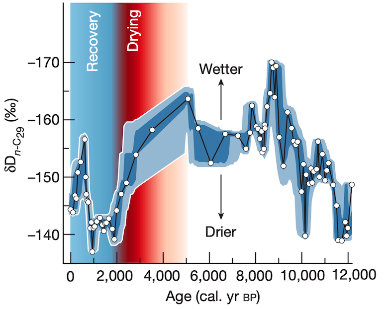
Furthermore, the tropical forest overlying the peat responded to the drying. Preserved pollen grains in the peat show that the swamp-adapted species were largely lost by 2,000 years ago, replaced by forest species that were better suited to drier conditions.
Critically, once the climate stopped drying, the swamp-adapted species returned, and peat began to build up once again.
Our interpretation of the data is that, as the climate dried, the water table of the Congo peatlands lowered, exposing layers of peat to the air. Peat was oxidised and so decomposed. This drying resulted in the loss of peat, including peat that was older than the drying event that triggered it. This is known as “secondary decomposition”.
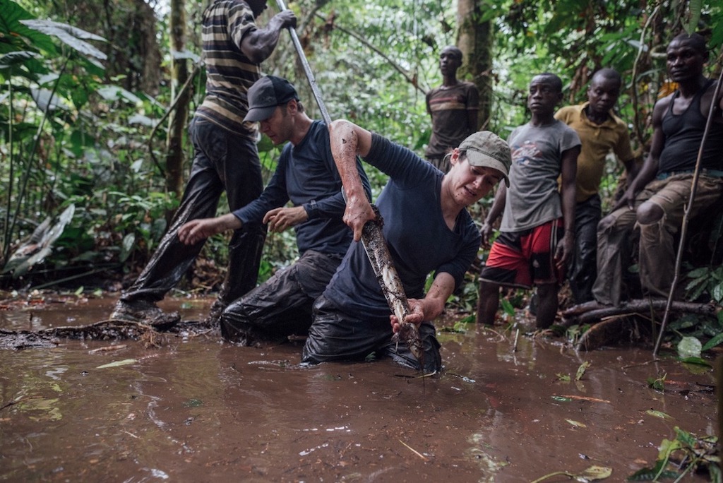
Later, we undertook new arduous fieldwork in two more remote locations in the Democratic Republic of the Congo, some 177km and 274km away from our main peat core.
The new peat cores we extracted and analysed both showed the same ghost interval and a strikingly similar timeline. This suggests that the decomposition event happened across the world’s largest tropical peatland.
Wider implications
The drying climate we find agrees with other studies in the western part of the Congo forest, and is consistent with what is referred to as a “rainforest crisis” about 2,000 years ago.
These studies show that, in many areas, the rainforest was temporarily replaced by open, woody savannah vegetation – a mixed tree and grassland ecosystem.
Whether these vegetation changes were the result of a drying climate or widespread deforestation by people during the African Iron Age has divided scientists. Our peatland study shows there was clearly a climatic component to these changes, as people did not affect the remote peatlands we studied.
Estimating how much carbon was lost from the peatlands requires models to simulate peatland development and carbon balance for the region. However, these do not yet exist.
In the meantime, using the rate of peat accumulation before and after the ghost interval, we estimate that between two and four metres of peat was lost from the main peat core we analysed.
For context, the peat at that location is six metres thick today. The amount of carbon lost across the peatlands is therefore likely to be on the order of billions of tonnes, emitted over timescales of at least decades and possibly centuries.
A new tipping point?
The new research shows that the climate space in which the central Congo peatlands exist today is much drier than the tropical peatlands of south-east Asia and the Amazon.
The central Congo peatlands are much more vulnerable to drought than other tropical peatlands and clearly lie close to a drought tipping point where they may begin to release some of the 29bn tonnes of carbon stored in the peat.
Central Congo has two dry and two wet seasons annually, due to the migration of the Intertropical Convergence Zone (ITCZ) – a band of low pressure around the equator that influences the rainfall of much of the tropics.
There is some evidence that the length of the second annual dry season in the Congo basin has been lengthening over the past two decades. If this continues, the peatlands could begin releasing carbon to the atmosphere again. However, we do not know if this trend will continue as some climate models indicate further droughts going forward, while others show fewer droughts.
It may be that the carbon in the peatlands is safe from future emissions. However, if not, they may soon begin to accelerate climate change in a dangerous positive feedback loop. We just do not know at present. However, our new research provides a stark warning from the past.
There is an urgent need for more data and modelling to assess where the tipping point for central Congo peatlands drought lies, and which emissions pathways may trigger it.
The world’s largest tropical peatland, within the world’s second largest region of tropical forest, must not continue to be a neglected region for investment in science. The Congo basin forests and peatlands are globally important and so the scientific focus for the region should match its significance.
Article information
Garcin, Y. et al. (2022) Hydroclimatic vulnerability of peat carbon in the central Congo Basin, Nature, doi:10.1038/s41586-022-05389-3