Guest post: Understanding the UK’s recent spike in wildfires

Dr Thomas Smith
07.03.19Dr Thomas Smith
03.07.2019 | 11:49amDr Thomas Smith is assistant professor in environmental geography in the Department of Geography & Environment at the London School of Economics.
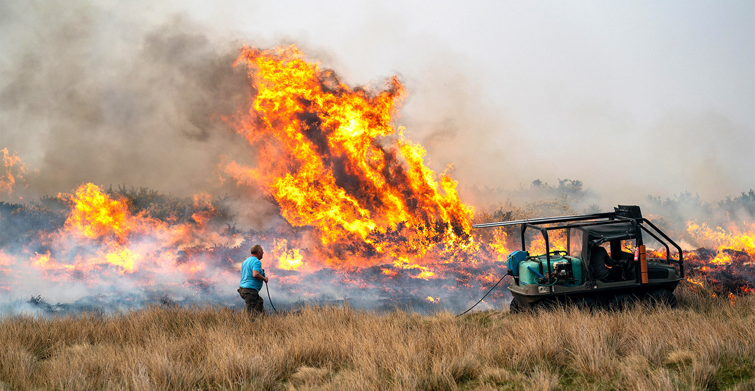
Last week marked the one-year anniversary of the Saddleworth Moor wildfire. The fire, which burned through 1,800 hectares of moorland just upwind of Manchester, saw people being evacuated from their homes, hazardous air pollution and the loss of important peat carbon stores.
While this fire was unprecedented, the UK has seen the same moorlands burning again in February and April of this year.
The Easter weekend also saw one of the largest UK wildfires ever recorded in Morayshire, Scotland. The fire burned through 7,000 hectares of grassland – equivalent to the area of Nottingham – and was more than three times larger than the 2018 Saddleworth fire.
Through my role as a UK representative to the European Cooperation in Science and Technology Action on Wildfires and Society, I will be collaborating with dozens of scientists and practitioners from 34 European countries to evaluate the state of our knowledge about wildfire activity and good practice for wildfire preparedness and prevention.
The unprecedented UK wildfire seasons in 2018 and 2019 have raised key questions about how fire risk in the UK is changing and how we can prepare for them in future.
Is there a trend?
The majority of wildfires in the UK are started by humans – either by accident or arson – and mostly occur in heathland or grassland environments, although forest fires can happen too.
The peak seasons for wildfires are the spring and summer, when low vegetation moisture leads to an increased risk of fire ignition and spread.
While wildfires rarely threaten lives in the UK, the environmental and economic impacts can be significant.
Such impacts include the loss of ground-nesting bird and reptile habitats, the production of smoke pollution and the loss of long-term peat carbon stores. (UK peat soils store more carbon than the combined forests of Britain, France and Germany.) There are also impacts on infrastructure through road closures and the contamination of water supplies.
Wildfire activity is usually measured by annual burnt area and the number of fires. These measurements come from satellites or on-the-ground incident reporting and surveying.
The European Forest Fire Information System (EFFIS) has one of the longest records of wildfire activity for the UK, extending back to 2008.
As the chart below shows, 2019 – up to the end of June – has already eclipsed the annual record for the largest burnt area (29,334 hectares) and highest number of fires (135). These records were previously held by 2018.
Number of UK wildfires (top) and average area burned (bottom) per year from 2008-19. Data from the European Forest Fire Information System (EFFIS). Chart by Carbon Brief using Highcharts.The EFFIS data comes from satellite mapping of burnt area. Only fires larger than 30 hectares are reliably mapped due to the limits of the satellite instrument’s pixel size. This is a problem for the UK, where many wildfires are small due to the patchwork nature of the countryside.
EFFIS state that their system only detects a small fraction of the total number of fires, but that the total burned area is only underestimated by 20–25%, given that a small number of large fires are responsible for most of the burned area.
This supports the findings of the UK’s Forestry Commission, who found that the UK Fire and Rescue Services attend an average of 32,000 wildfire incidents each year, of which the vast majority (>99%) are smaller than one hectare.
(The Forest Commission has not yet verified its wildfire data for 2018 and 2019.)
Climate influence
There are no long-term datasets for wildfires in the UK, which makes it difficult to discern whether the recent spike in activity detected by EFFIS is unusual.
Perhaps our best source of knowledge comes from the UK’s senior fire officers, some of whom are now publicly acknowledging their experience of a longer wildfire season, and increasing scale of wildfires.
To understand how wildfires are changing, scientists need to understand how climate change will affect three key factors: weather, sources of ignition and “fuel” – the vegetation that fires burn through.
Predicted warmer and wetter winters in the UK could result in a longer growing season, which will in turn see a greater abundance of vegetation, or available fuel for a wildfire.
The UK is also expected to see more frequent and longer-lasting heatwaves. This could cause vegetation to dry out, leaving it more likely to catch alight.
Warmer summers are also likely to lead to more people participating in outdoor recreation activities – a major source of fire ignitions via campfires and barbecues.
Researchers have modelled these climate change impacts for the Peak District in the UK and found that a combination of higher temperatures and a rise in the risk of ignition due to increased recreation will likely lead to more summer wildfires towards the end of this century.
Fire-proofing the countryside
To prepare for a possible increase in wildfires in the future, researchers are working with land managers to come up with new ways of reducing the risk.
Land managers already have a number of options to reduce intensity and potential spread of a wildfire. These include intentionally burning heathlands and forests during low-risk months – in order to get rid of potential fuel. Land managers may also introduce “fire breaks” – gaps in vegetation – in order to stop fires from spreading.
The UK government recently announced plans to plant more than 11m trees – partially in a bid to remove greenhouse gases from the atmosphere.
To protect those trees from fire, the UK’s Forestry Commission has been working closely with researchers to come up with new measures. These could include introducing “fire belts” – corridors of fire-resistant tree species – into tree plantations. Trees could also be planted in “patchwork forests” with regular breaks to reduce the risk of fire spread.
Another key area of development is in the use of models to predict fire weather, fire danger and to simulate the potential spread of a fire and need for evacuations.
The Met Office Fire Severity Index (MOFSI) currently forecasts fire weather for the UK, rating “fire severity” – the amount of damage a fire might cause in the case of an ignition – from low to exceptional. However, this index is based on a system designed for Canadian forest fires and and research has shown this to be inadequate for the UK’s mix of heathland and forest environments.
A more sophisticated approach could be a “Fire Danger Rating System”, which would account for different plant types and plant abundance across the UK. This is now being developed for Scotland, and a recent funding call was issued for the development of a system for England and Wales.
Some of my research involves the simulation of high-impact wildfires, such as the 2011 Swinley-Crowthorne forest fire – and working with evacuation modellers to evaluate more efficient escape routes for at-risk populations.
International co-operation between communities in the UK and abroad has also been key to improving preparedness. Fire and Rescue Services have been sending firefighters to training camps in Spain and the US to learn from specialist wildfire teams.
The Welsh firefighters pictured below are learning how to fight fire with fire, by burning fuel breaks into the landscape ahead of an advancing wildfire.
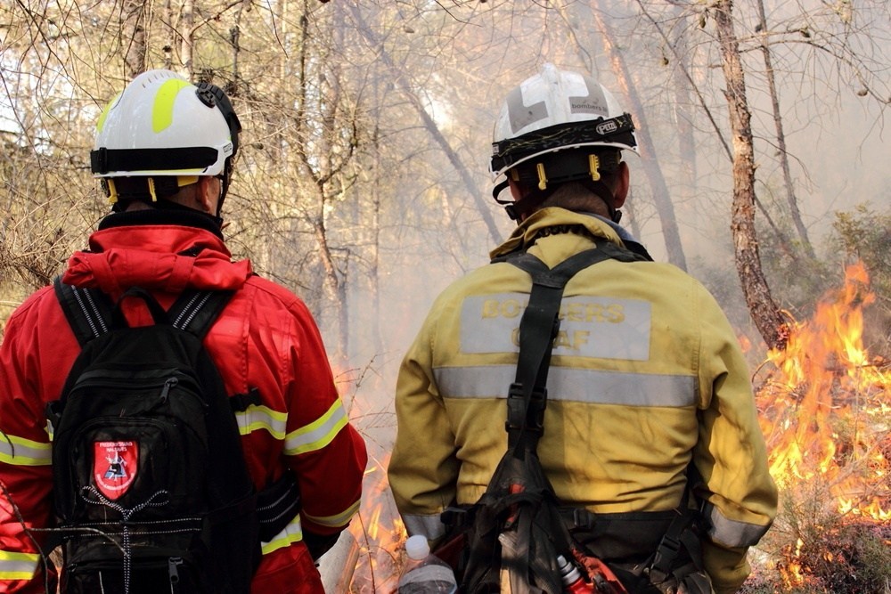
Photo taken at a Pau Costa Foundation training course for UK firefighters and land managers in Catalonia, Spain. Source: Dr Thomas Smith
With “severe wildfires” appearing on the UK’s National Risk Register of Civil Contingencies in 2013, it is clear that the increased risk posed by the climate emergency is beginning to be taken seriously by the UK government. Planning ahead so that we can learn to live with more flammable landscapes is now more important than ever.