Roz Pidcock
24.02.2014 | 5:15pmLast week, the Daily Mail accused the Met Office of issuing a “pitiful” forecast in the run up to the period of exceptional flooding that engulfed the country.
With the Met Office defending its predictions, we take a closer look at how the Met Office makes weather forecasts, how reliable they are and what it predicted ahead of the recent stormy period.
Front page forecast
Climate change is featuring more in the national conversation as the media, politicians and commentators try to make sense of the recent weather. But no sooner were flood waters starting to retreat than accusations started flying over who or what is to blame.
On Friday last week, the Daily Mail launched a front-page attack on the UK’s official weather provider, the Met Office, for what it called “the worst weather prediction since Michael Fish reassured the nation in October 1987 that there was no hurricane on the way”.
The paper criticised the Met Office’s forecast ahead of the recent stormy period between December and February. Rather than foretelling the exceptional weather, the Mail says the Met Office forecast predicted a “drier than normal” winter. The Mail article’s headline reads:
“Could Met Office have been more wrong? Just before floods, report told councils: Winter will be ‘drier than normal’ – especially in West Country!”
The Independent and the Telegraph repeated the story. But on Friday, the Met Office suggested the papers had misinterpreted the forecast.
Three-month outlook
The Mail article makes bold claims about the Met Office’s forecast for how much rain the country would get this winter. The paper claims:
“[The Met Office] assured councils there would be a ‘significant reduction in precipitation compared to average’ for most of the country, adding that there was only a 15 per cent chance the winter would fall into the ‘wettest category'”
However, a look at the actual forecast suggests the Met Office was more specific in what it predicted. The forecast summary reads:
“Confidence in the forecast for precipitation across the UK over the next three months is relatively low. For the December-January-February period as a whole there is a slight signal for below-average precipitation.
The probability that UK precipitation for December-January-February will fall into the driest of our five categories is around 25% and the probability that it will fall into the wettest category is around 15%”
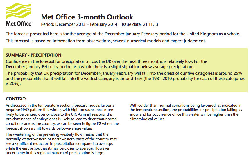
The Met Office three-month forecast for December to February. Click on image for close-up or here for more.
A matter of probabilities
Clearly, this winter has not seen below average precipitation. Official figures – again, from the Met Office – show this winter has been the wettest since records began in 1910.
But what the Mail hasn’t incorporated in its reporting is the probability-based nature of the Met Office forecast. The forecast shows the following chart:
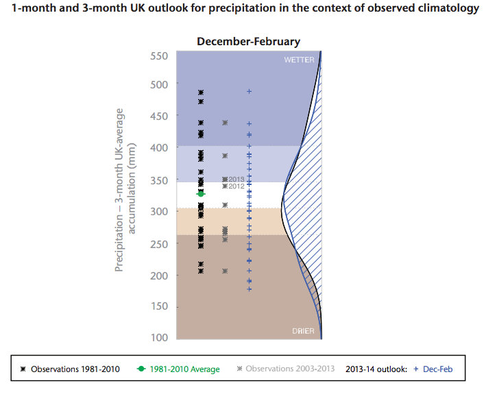
The blue curve shows the likely rainfall per month for the whole winter. You can see the most likely amount predicted is between 300 and 350 millimetres – where the curve ‘bulges’.
Higher or lower values were also possible – just less likely. Where the bulge peaks is just a little below the long term average rainfall for winter months of about 330 mm – marked by the green dot. But importantly, a large part of the blue curve is still above the green dot.
So while the forecast says that overall, there’s a “slight signal for below-average precipitation”, the probabilistic chart shows wetter than usual conditions are also quite possible. (The black curve shows the same thing, just for December.)
All of which might illustrate the perils of writing – and reporting – probabilistic forecasts. In a statement on Friday, the Met Office explained its long range forecasts assess risk. They don’t make definitive predictions. It said:
“It’s a bit like the science-equivalent of factoring the odds on a horse race. However, as with any horse race, it’s always possible that the favourite won’t win – so these probability scenarios have to be used in the right context.”
The map below – taken from a Met Office report a few weeks ago – shows southern parts of the country have borne the brunt of the wet weather.
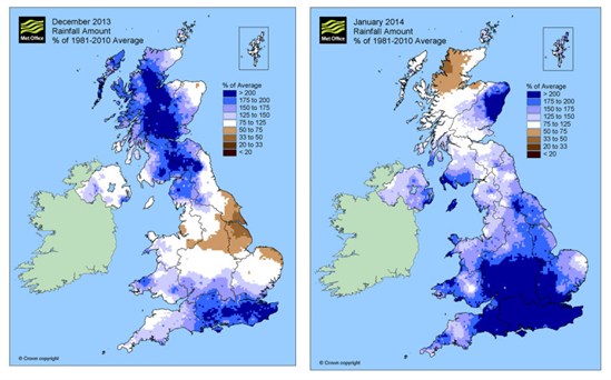
Total rainfall in December and January compared to the 1981 to 2010 average. Source: Met Office report on “The recent storms and floods in the UK”
The Mail article also claims that “forecasters said the Somerset Levels and the rest of the West Country would be especially dry”. But the Met Office corrected this in its statement :
“[T]he outlook assesses the level of risk connected to five different scenarios for both temperature and rain/snowfall for the UK as a whole; they do not mention specific areas such as the West Country or the Somerset Levels.”
Short term vs long term
The Met Office issues several different kinds of forecasts. The type the Mail story focuses looks a full three months into the future – a “long range forecast”.
The Met Office says it doesn’t issue this type of forecast to the public because it’s still in ” experimental phase” – a point the Mail article notes. Instead, it only goes to contingency planners to give a rough idea of how likely different weather events are looking at the time.
The forecasts that are made available to the public look over much shorter periods, from one to 14 days in advance.
While there are lots of uncertainties with long range forecasting, meteorologists can put much greater confidence in short term predictions, which look just a few days ahead.
The Met Office’s analysis indicates that this winter, more than 93 per cent of daily maximum temperature forecasts were accurate to within two degrees Celsius. Figures for December and January show just over 73 per cent of three hour rain forecasts were correct too. You can check how Met Office forecasts are performing against targets, here.
A chaotic system
Why is it so difficult to forecast the next three months? The processes that produce our weather are known as “chaotic” systems. That means they’re not predictable – while scientists know some aspects of how they behave, there will always be some uncertainty.
Meteorologists weigh up the likelihood of different outcomes and express forecasts as probabilities rather than as a precise prediction. For example, the Met Office predicts at least a 40 per cent chance of rain in London this evening.
But predicting the weather a long way into the future means weather systems can end up doing something unexpected. The longer the forecast period, the more difficult it is to predict what will happen. On its website, the Met Office provides very helpful guidance for how to interpret long range forecast. In the statement on Friday, the Met Office clarified:
“These outlooks are not like our other forecasts â?¦ it’s not currently scientifically possible to provide a detailed forecast over these long timescales.”
Furthermore, the Met Office’s long range forecast issued in November came with the clear warning that it “should not be used in isolation” but should be used together with the short term forecasts to get the best picture of what to expect.
Knowing how to interpret forecasts is important. If nothing else, perhaps the Mail’s interpretation is a good demonstration of why the Met Office isn’t making its long range forecast public just yet.