Hurricane Patricia: The role of El Niño, climate change and good fortune
Roz Pidcock
10.26.15Roz Pidcock
26.10.2015 | 6:09pmThe strongest hurricane ever seen in the western hemisphere came ashore in southwest Mexico at 6:15pm local time on Friday. Looming menacingly off the coast, US scientists branded it “potentially catastrophic”. But a stroke of luck meant it caused far less damage than feared.
Why did Patricia spin up so fast? What factors helped lessen the blow? Carbon Brief looks at the role of climate change and other factors in understanding what made this hurricane so unusual.
Extraordinary spin-up
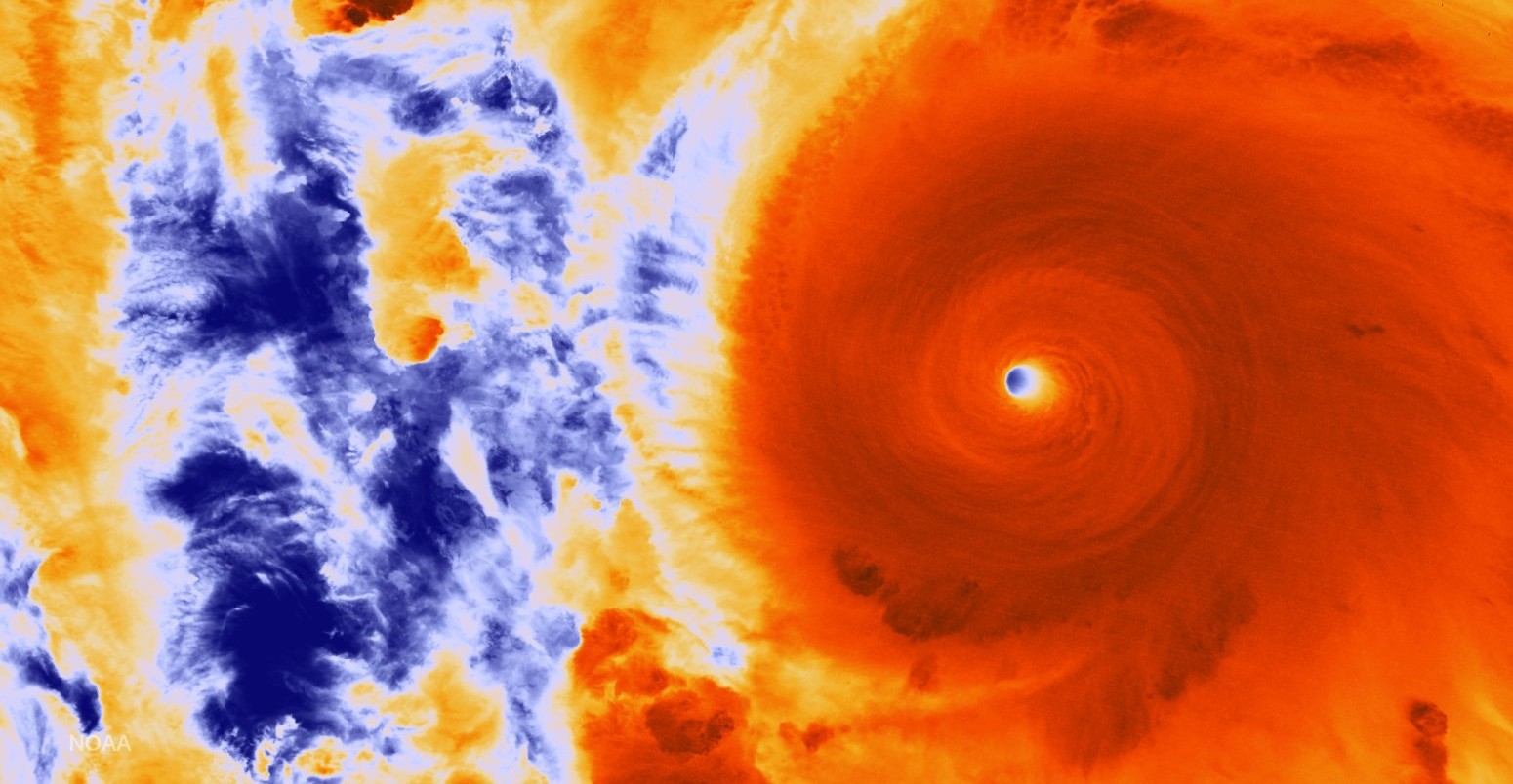
At her peak, Patricia’s winds reached an unprecedented 200mph. This is a long way above the threshold of 156mph that classifies a hurricane as Category 5 – the highest possible rating. Some scientists were saying Patricia would have been Category 7, if the scale extended that far.
Low air pressure in the core – a measure of storm strength – bottomed out at 879 millibars, making Patricia, officially, the most powerful hurricane ever measured in the western hemisphere.
Scientists use satellites to detect hurricanes and keep a close eye on how they develop. This image from NOAA shows Patricia hurtling towards Mexico’s coast on Friday.
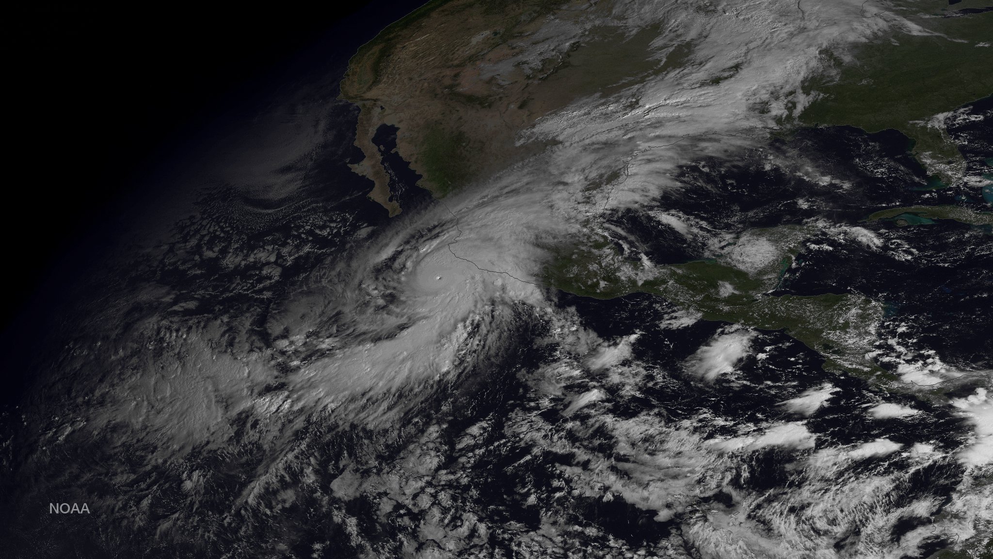
Hurricane Patricia taken from the Suomi NPP satellite’s VIIRS instrument on October 23, 2015. Credit: NOAA/NASA.
Satellite images showed Hurricane Patricia spinning up to a Category 5 storm with startling speed. Peak wind speed increased from 85mph to 200mph in just 24 hours. Wunderground, an online weather service founded by Dr Jeff Masters, explains:
This places Patricia among the most rapidly intensifying tropical cyclones ever witnessed anywhere in the world since the advent of modern meteorology.
Incidentally, scientists know exactly how strong Patricia was because once satellites spot it and can track its course, stormchaser pilots fly directly to the centre to take measurements.
The crew of #NOAA43 (@NOAA P3) from the historic flt on 10/23/15 into hurr #Patricia. 879 refers to lowest pressure pic.twitter.com/WFiuZoNDcO
— NOAAHurricaneHunters (@NOAA_HurrHunter) October 24, 2015
So, what caused Patricia to spin up so quickly?
Warm water fuels storms
Hurricanes feed off warm water and the theory that rising ocean temperatures are making them stronger than they would otherwise have been has been around for a long time.
While pinpointing a trend has so far been hampered by poor data records, scientists expect to see more storms of this strength as ocean temperature rises further.
As well as the ongoing influence from climate change, this year has been a bit special.
The huge El Niño happening in the Pacific has made water in the region where Patricia formed even warmer than usual, adding further fuel to any storm that passes through.
While there are more hurricanes off the west coast of America during an El Niño year, there are fewer off the east coast. Of the record-breaking 22 hurricanes recorded this year in the northern hemisphere, 21 have been in the western, central or eastern Pacific basins, with Hurricane Joaquin the only one to reach Category 4 in the Atlantic this season, explains The Weather Channel.
Making landfall
A few hours before Patricia hit landfall, scientists were warning of “potentially catastrophic” damages. A public advisory issued by the US National Hurricane Centre :
Patricia is expected to remain an extremely dangerous category 5 hurricane through landfall…Preparations to protect life and property should be rushed to completion.
.@NASANPP VIIRS imagery of #Patricia. Landfall as a Catagory 5 storm expected within 12hrs. https://t.co/JBalL2pAXM pic.twitter.com/4iGmes0dA4 — NOAA Satellites (@NOAASatellites) October 23, 2015
While the storm still caused a lot of damage – with reports of heavy rain, flooding, landslides and several casualties – Hurricane Patricia caused far less destruction than feared. Why?
Patricia was still a Category 5 when she hit landfall in Mexico, but, by then, peak wind speed had dropped to 165mph. The strongest winds were also concentrated close to centre, limiting the amount of damage the storm could wreak. The storm’s course took it through the middle of the coastal resorts of Manzanillo and Puerto Vallarta, which were relatively quiet at the time.
Patricia weakened rapidly as she hit the mountainous regions of central Mexico. By Saturday morning, the US National Hurricane Centre had downgraded Patricia to a tropical storm, falling further later that day to what’s called a “remnant low“.
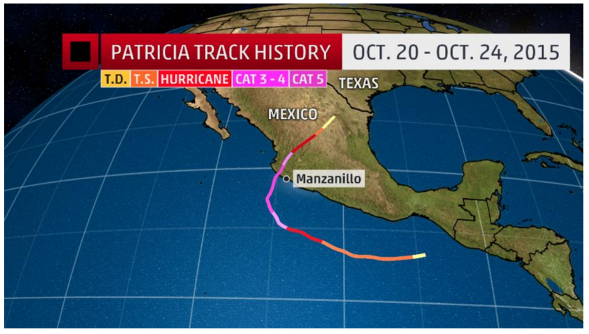
Hurricane Patricia’ course. Source: The Weather Channel.
A number of other factors contributed to Patricia causing less damage on impact.
Rising sea levels mean that when a hurricane hits land, the storm surge it produces can overwhelm coastal defences and cause flooding. This is part of what made other storms, such as Hurricane Katrina, so damaging.
Though scientists warned about “large and destructive” waves, Patricia spun up so fast that there wasn’t sufficient time, Jeff Weber, a scientist at the National Centre for Atmospheric Research in the US, tells the New York Times. He says:
It was born so quickly and so close that it didn’t really have time to build up the storm surge.
Scientists know that a warmer atmosphere can hold more moisture, meaning there’s more water available to fall as rain when a storm hits. But Patricia moved at such a speed that rainfall didn’t concentrate in any one area for too long.
Between 20-25 October, total rainfall reached over 409mm (16.1 inches), but was distributed across a large area, as the map below from NASA shows.
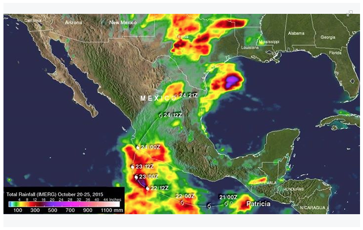
Hurricane Patricia’s Rainfall from Space from Oct 20 to 25 using data from the Global Precipitation Measurement. Credit: NASA/JAXA/SSAI, Hal Pierce.
Quick action
Accurate forecasts, quick action by the Mexican authorities and a fair amount of luck meant fewer people were hurt than might have been. Early estimates put insurance losses at $500m, also considerably lower than expected.
Does this mean the storm was overhyped, as some media outlets suggested?
Emphatically “no”, says Dr Marshall Shepherd, professor of atmospheric science at the University of Georgia. The fact that it didn’t cause a lot of damage doesn’t means the emergency calls weren’t warranted, he writes in Forbes magazine:
I have no issue with the National Hurricane Center using language like “potentially catastrophic storm” because it certainly had that potential…A slight last minute shift in track or eyewall size would have changed everything.
Brad Plumer over at Vox echoes this sentiment, saying:
It’d be wrong to say Patricia was overhyped…Rather, Patricia ended up mercifully passing through a sparsely populated area. And, crucially, Mexico is getting much better at dealing with tropical storms…This time around, orderly evacuation efforts likely saved lives.
Scientific evidence points towards Patricia’s strength likely being bolstered by climate change and tipped over the edge into record breaking territory by El Niño. While every storm has its own characteristics and quirks, this one being particularly unusual, a warming global ocean means we’re likely to see more storms of this strength in future.
Main image: Hurricane Patricia’s Eyewall on October 23, 2015. Credit: NOAA/NASA.
-
#HurricanePatricia: The role of El Niño, climate change and good fortune
-
Carbon Brief looks at the role of climate change and other factors in understanding what made #HurricanePatricia so unusual