Interactive: How satellites are used to monitor climate change
Hundreds of kilometres above the Earth’s surface, a vast network of satellites is collecting data to help us better understand the climate system.
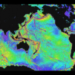
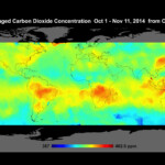
Since the launch of the first weather satellite in 1959, Earth observation satellites have proven to be vital tools for climate research. In 1984, the Earth Radiation Budget Satellite provided an early insight into how human activities, such as burning fossil fuels, affect the planet’s radiation balance, and helped discover the hole in the ozone layer. Two decades later, the Orbiting Carbon Observatory mission gave us the first global maps of carbon dioxide concentration around the world (see gallery below).
The latest addition to this network of global satellites is the European Space Agency’s (ESA) Sentinel-3A, launched on Tuesday evening from Russia’s Plesetsk Cosmodrome. The new satellite is designed to help fill in gaps in the data on sea-surface temperature and map the extent and topography of ice, among other purposes.
So, what’s up there in the Earth’s atmosphere? Carbon Brief has catalogued all the satellites currently in operation that are adding to scientists’ understanding of climate change.
A global view
Pulling together data from the World Meteorological Organisation, NASA, NOAA and elsewhere, there are 162 “climate satellites” that are either active or semi-operational. We’ve compiled a list of all these satellites into a spreadsheet below.
Our analysis takes a fairly broad definition of what might be described as a climate satellite. For example, we include both publicly and privately funded satellites that have additional purposes unrelated to climate science, such as communications or surveillance. It is worth noting that data from some of these satellites will be harder to access than others: not all agencies or organisations make their data readily available to the scientific community.
Looking at the interactive visualisation above, the satellites fall into two categories. Those in a geostationary orbit cruise at the very precise altitude of 35,786km, remaining above the same spot on earth. The second group are those with low-earth orbits, circling at a height of around 400-1400km above Earth’s surface.
The different orbits serve different purposes. A geostationary orbit allows satellites to continually monitor a particular region uninterrupted. Satellites in a low earth orbit can directly monitor the climate from their position within or just above the atmosphere, and can provide near-global coverage as they scan over different swathes of ground with each orbit.
The graph below shows a zoomed-in view of the satellites in a lower earth orbit, that have been launched since 2000:
The satellites in the graph are categorised according to their primary area of observation. Land observation satellites tend to be in a lower orbit. Travelling closer to the earth means they can get a more detailed view of the land.
International collaboration
Climate satellites are operated by agencies around the world, from Kazakhstan to Chile. But not every country has the resources to support their own satellite. The graph below shows that large nations such as China, India and the US top the list of countries with the most climate satellites in operation, along with multinational collaborations.
Individually, European countries might appear underrepresented. But the many missions of ESA and the European Organisation for the Exploitation of Meteorological Satellites (EUMETSAT) show that Europe is a key player when it comes to climate satellite research.
Why are satellites so important?
As a vehicle for research, satellites aren’t cheap. The contract to build Sentinel-3A was worth €305m back in 2008, and last week ESA signed a €450m contract for two more satellites in the Sentinel-3 mission.
Carbon Brief asked Dr Simon Keogh, head of the satellite data products and systems group at the Met Office, why satellites are worth the money:
Sentinel-3A, which launched earlier this week, will add to this global coverage, filling in for the Envisat mission which failed in 2012. Dr Keogh explains: