Low-lying atolls could become ‘uninhabitable’ earlier than thought
Robert McSweeney
04.25.18Robert McSweeney
25.04.2018 | 7:45pmLow-lying coral islands across the tropical oceans could become “uninhabitable” in the coming decades because of the combined impacts of sea level rise and large waves, a new study suggests.
Earlier research, based on sea level rise alone, suggested this wouldn’t happen until at least the end of this century.
But regular inundation from coastal flooding could push islands beyond a “tipping point” where groundwater resources cannot recover from infiltration by salty seawater, leaving residents with no drinkable water.
The study focuses on one atoll of the Marshall Islands, but the warning also applies to other populated atolls in the Pacific and Indian oceans, the researchers say – including those in the Cook Islands, Maldives, Seychelles and Hawai’i.
However, the study may be giving an overly-pessimistic outlook, other scientists tell Carbon Brief. This is partly down to the sea level rise scenarios used, but also because many other atolls still support residents without usable groundwater.
Rising seas
For the world’s small island nations, the threat of rising seas looms large. Their long-term survival hinges on how effectively climate change is mitigated and sea level rise is curbed. It was no surprise, therefore, that small island states were determined to enshrine the 1.5C warming limit in the Paris Agreement.
But as the new Science Advances study explores, rising sea levels carry another menace – they allow high waves to reach further up – and potentially over – shorelines.
At particular risk are low-lying atolls – tiny tropical islands formed from coral reefs – which can be just a couple of metres above sea level.
The diagrams below illustrate how sea level rise and large waves together increase the risk of flooding, for current (top) and future (bottom) sea levels.
Higher sea levels allow larger waves to travel across the reef towards the shore. Larger waves means a bigger wave “run-up” – i.e. how high the swash of a wave reaches up the beach – and a greater risk of “overwash” of water over the top of the beach.
Lead author Dr Curt Storlazzi, a research geologist and oceanographer at the US Geological Survey, sums the process up in a pithy sentence:
“If sea level rises, there will be larger waves, greater run-up, more overwash, and coastal flooding.”
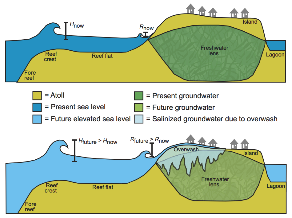
Conceptual diagram of the influence of sea level rise on wave heights, wave-driven run-up, and flooding and the resulting impact on atoll island groundwater – for current (top) and future (bottom) sea levels. H = wave height, and R = wave-driven run-up. Source: Storlazzi et al. (2018)
While coastal flooding might bring to mind destruction of homes, infrastructure and livelihoods, it also threatens freshwater resources, the study says. Salty seawater can infiltrate an island’s groundwater source, known as a “lens”, rendering the water undrinkable.
Case study
The study focuses on Roi-Namur island on the Kwajalein Atoll, which is one of the 1,100 low-lying islands and 29 atolls of the Marshall Islands in the Pacific Ocean.
The island makes an ideal case study for two reasons: first, it has recently been flooded; and second, it has a network of wells that allows scientists to monitor its groundwater resources.
![]()
During the flooding event in March 2014, waves of more than six metres coincided with spring high tides, causing seawater to overtop the beach in northern parts of the island and wash inland. Groundwater levels subsequently rose by almost one metre as salty water soaked into the ground, contaminating the freshwater.
The researchers used the data they collected from the event to validate their coastal and groundwater models. Confident that their models could accurately model current events, they then ran simulations for the future.
The study considers three pathways of future climate change: an intermediate scenario (“RCP4.5”), a business-as-usual scenario (“RCP8.5”), and a more extreme version of RCP8.5 that incorporates larger contribution of meltwater from the Antarctic ice sheet. This last scenario is a “high-end, low probably – but obviously high impact” scenario, says Storlazzi.
For the mid-century (2055), sea levels under the three scenarios are projected to rise by 0.3m, 0.8m and 0.9m, respectively. For the end of the century (2105), this increases to 0.7m, 2.0m and 2.9m, respectively.
![]()
The results suggest that sea level rise alone would not affect most of the island until the end of the century. However, when the impact of large waves is included, the island is likely to “experience more severe annual wave-driven flooding events”, the paper says.
The chart below illustrates this more clearly. It shows the percentage of Roi-Namur flooded every year as a result of sea level rise alone (solid lines) and the combined impact of rising seas and large waves (dashed lines) under the three climate change scenarios.
The findings suggest sea level rise and large waves will cause regular flooding by mid-century. The subsequent damage could hit a “tipping point” whereby freshwater supplies become too salty to drink and flooding occurs too frequently for it to recover. This would make the island uninhabitable “within the lifespan of current residents”, the study says – around 2030-40 under RCP8.5 and 2055-65 under RCP4.5.
Thus, the mix of rising seas and large waves means “the timeline for sustainable human habitation on these low-lying atoll islands shortens considerably”, the paper says.
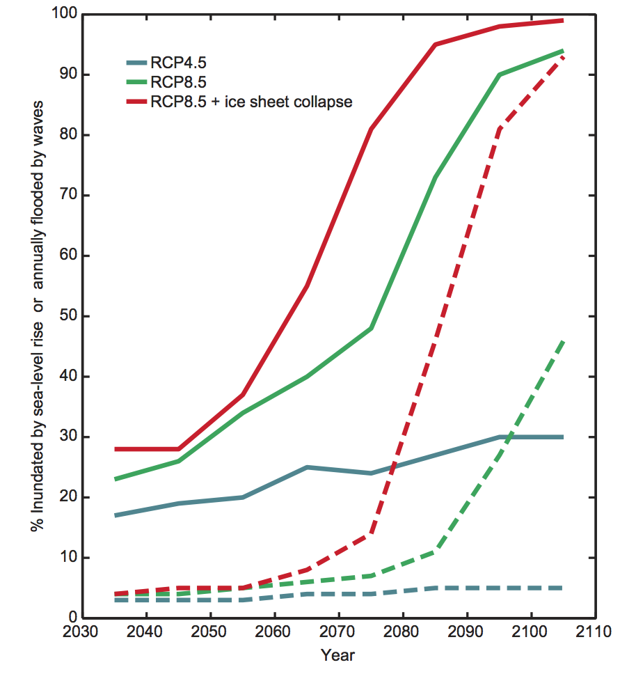
The projected percentage of Roi-Namur inundated because of sea level rise alone (dashed lines) and flooded annually because of the combined effects of waves and sea level rise (solid lines) for three climate change scenarios. Source: Storlazzi et al. (2018)
By assessing the combined impact of sea level rise and waves, the study shows that “one plus one doesn’t equal two”, says Dr Kris Karnauskas from the University of Colorado at Boulder, who was not involved in the research, but led a recent study on how small islands are likely to become increasingly arid over this century. He tells Carbon Brief:
“Sea level rise and changes in wave characteristics play off each other such that annual inundation – and, therefore, when islands become uninhabitable – occur earlier than expected by those factors individually.”
However, as Prof Bob Kopp – director of the Institute of Earth, Ocean & Atmospheric Sciences at Rutgers University – points out, the sea level rise scenarios in the study weren’t originally intended to be used as forecasts.
The scenarios were developed for the Department of Defense by the US government’s Coastal Assessment Regional Scenario Working Group (CARSWG), Kopp explains in a response he posted online:
“These scenarios were intended as tools for risk management, not as forecasts of what would be likely under different emissions scenarios.”
As a result, the conclusion that the island could become uninhabitable in the 2030s is “overly pessimistic”, Kopp says. Nonetheless, even under 1.5C of warming, groundwater supplies on Roi-Namur and other islands in the region “will be rendered irrevocably contaminated within the lifetime of a 8-year-old child alive in the Marshall Islands today”, he warns.
Populated islands
Roi-Namur is one of the many thousands of atolls dotted across the world’s oceans, the researchers say – in fact, it is probably at a higher elevation than most.
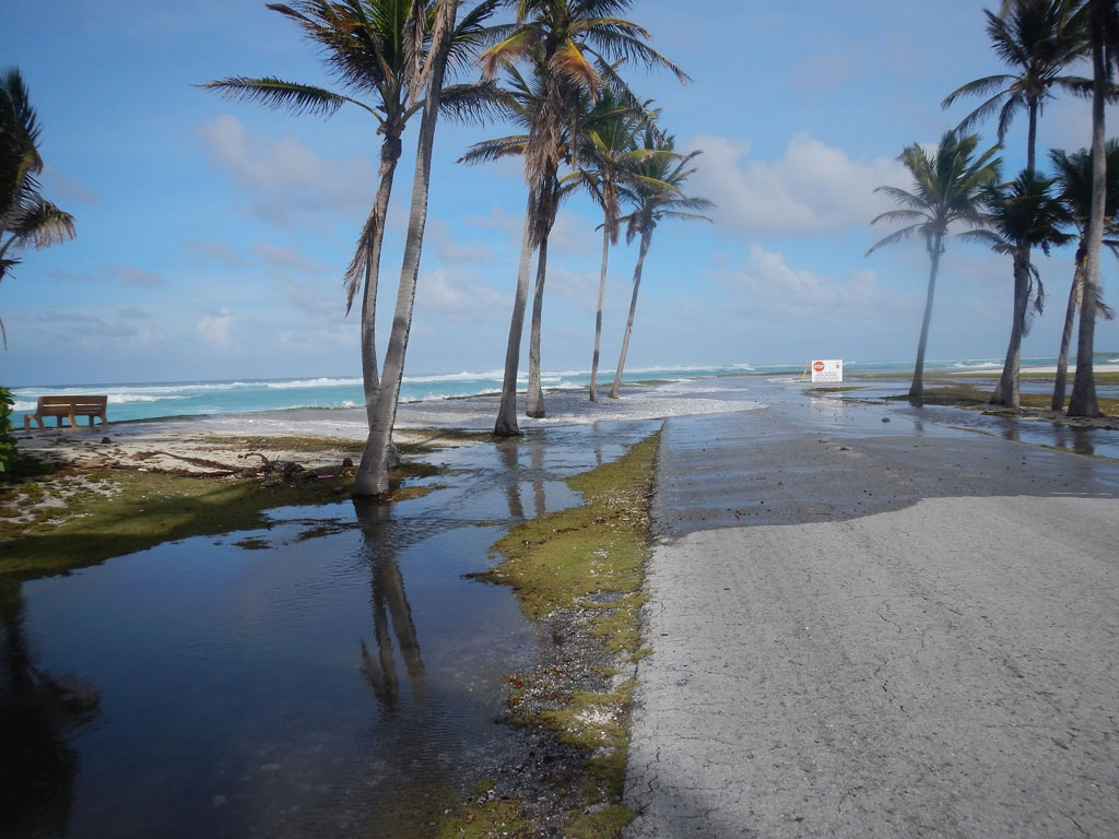
Flooding event on Kwajalein Atoll in the Republic of the Marshall Islands in March 2014. Credit: Peter Swarzenski (USGS)
In addition to the Marshall Islands, atolls in the Caroline Islands, Cook Islands, Kiribati, Line Islands, Maldives, Seychelles, Society Islands, Spratly Islands, northwestern Hawai’i could all face similar risks. Storlazzi explains to Carbon Brief:
“Many of these atoll islands may be impacted by wave-driven flooding within the next few decades, such that they will have their infrastructure, agriculture and habitats negatively impacted and will not have potable [drinkable] groundwater.”
The exact scale of these risks for other atolls would need further research, notes Karnauskas, but the initial findings are a cause for concern:
“I don’t see any reason why leaders and inhabitants of other, far-away island nations shouldn’t be looking at this result with some concern right now.”
However, Prof Paul Kench at the University of Auckland argues that Roi-Namur is less characteristic of other atolls. Kench, who was not involved in the study, is a coastal geomorphologist who recently published a study on how rising seas can allow large waves to add sediment to atoll shorelines and increase their land area.
He notes that Roi-Namur has been substantially modified. The Japanese constructed a causeway between the two parts of the island during their second world war occupation and today it is a test site for a US ballistic missile defence system.
Consequently, “it is representative of a very limited number of atoll islands,” he tells Carbon Brief.
And although “an increase in frequency and magnitude of flooding in coastal systems is now widely expected with increased sea level”, there are many reasons that affect whether an atoll becomes uninhabitable, Kench says:
“Many atolls islands do not have potable groundwater lenses or such lenses are polluted. However, they still host populations. Malé in the Maldives is a classic example. Potable water can be harnessed via rainwater harvesting. Consequently, island communities have different ways to provision themselves with freshwater – which allows islands to remain inhabited.”
This is a point picked up in the study, too. For example, islands that do not have to rely on groundwater exclusively – because of rainfall capture, desalination or water imports – will be more resilient to flooding, it says.
Similarly, islands that are not low-lying will likely not see their freshwater resources threatened, the paper notes. This is because these islands receive enough rainfall in their mountains that would be unaffected by coastal flooding. That said, infrastructure on these islands is still vulnerable to damage from inundation.
Storlazzi, C. D. et al. (2018) Most atolls will be uninhabitable by the mid-21st century because of sea-level rise exacerbating wave-driven flooding, Science Advances, doi:10.1126/sciadv.aap9741
Update on 25/04/2018: This article was updated to add comments from Bob Kopp
-
Low-lying atolls could be ‘uninhabitable’ within decades
-
Coastal flooding from sea level rise and large waves could see low-lying atolls become ‘uninhabitable’