Roz Pidcock
30.01.2015 | 2:20pmExpect to see more global temperature records tumble over the next few years, suggests the Met Office’s new forecast. Global average surface temperatures during 2015 to 2019 are expected to stay high, with a good chance of beating 2014 for the hottest year on record.
Every year the Met Office releases what’s called a “decadal forecast”. It’s designed to give us an idea of what we can expect in the next few years.
It’s new forecast, released online this week, says global temperature out to 2019 is expected to be in the range of 0.18 and 0.46 degrees Celsius above the long-term average.
This means we’re likely to see the mercury climb higher than in 2014, which saw a global temperature of 0.26 degrees Celsius above the long-term average.
Decadal forecasts
Decadal forecasts, also known as “near-term” forecasts, take into account natural fluctuations in the climate, as well as human influences.
The Met Office predicts global temperature over the next five years will be between 0.18 and 0.46 degrees above the 1981-2010 average. That’s 0.76 to 1.04 degrees above pre-industrial temperature.
The graph below shows the new Met Office forecast (blue shading) and real-world surface temperatures (black line), including the most recent data for 2014.
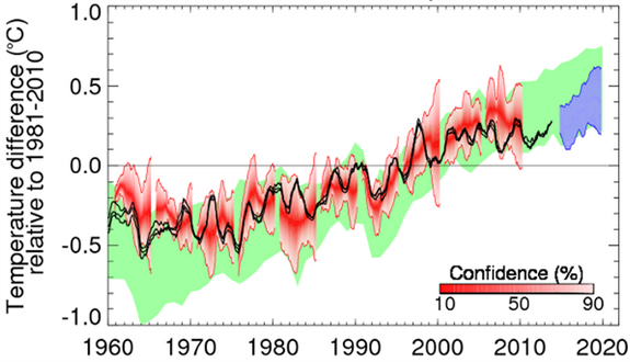
Observed global surface temperature (black line) and Met Office decadal forecast for 2015-2019 (blue shading) relative to 1981-2010. Previous predictions are shown in red. 22 model simulations from CMIP5 that have not been initialised with current observations are shown in green. Source: Met Office decadal forecast 2015-2019
The new forecast slightly edges up global temperatures expected over the next few years, compared to last year’s forecast for 2014 to 2018. That one predicted global temperatures between 0.18 and 0.43 above the long-term average. But the difference is only very small.
Dr Doug Smith, head of the Met Office decadal climate prediction team, tells Carbon Brief the scientists used the same basic model as last year, which includes current and expected levels of greenhouse gases, aerosols and changes in the Sun’s activity.
But before a forecast is made, the model is fine-tuned to reflect the latest temperature measurements from around the world. This process is called model “initialisation”.
Across the globe
The maps below show how the Met Office forecast for global temperature over the next few years plays out across the globe. The middle map shows the lower end of the forecasted range, the right map shows the upper end. The left map shows the most likely outcome.

Surface temperatures for the five-year period 2015-2019, relative to the 1981-2010 average. The left map is most likely forecast, the lower end of the forecasted range is in the middle, and the upper end of the range is on the right. Source: Met Office decadal forecast 2015-2019
The forecast shows enhanced warming over land and at high northern latitudes, adding:
“For the period 2015-2019 most regions are expected to be warmer than the average of 1981 to 2010, but regional cooling is possible over much of the Pacific, North Atlantic and Southern Ocean, and over some land regions.”
Temperatures set to stay high
Fourteen of the past 15 years have topped the charts as the warmest on record. But the difference between individual years has been slight, meaning temperature at the Earth’s surface has risen a fair bit slower than in previous decades.
Scientists suspect the main cause is that a large-scale natural climate cycle known as the Pacific Decadal Oscillation ( PDO) is in its negative phase, meaning more heat is finding its way to the deep ocean in the Pacific rather than staying at the surface.
Scientists aren’t able to predict when the PDO is likely to shift to its opposite phase, Smith tells Carbon Brief. That means the forecast can’t say when we’ll see the switch back to faster rates of warming. But being unable to predict an event is not the same as predicting it won’t happen, Smith adds:
“[Our forecast] doesn’t mean the PDO won’t shift in the next few years. It may even already be shifting. It’s just not something we can predict yet.”
The strong influence of natural variability is the reason why observations of surface temperature currently track the lower end of global climate models, such as those used by the Intergovernmental Panel on Climate Change (IPCC), the Met Office notes.
Those models, shown by the green shading in the top graph, predict the long-term trend in global temperature, but not the timing of all the ups and downs along the way.
A continuing trend
Forecasting global temperatures in the near term is a difficult task, Smith tells us. Scientists are still seeking to better understand many of the physical mechanisms that affect global temperature. But while there’s still a fair amount of uncertainty, on the whole, these forecasts have predicted similar rises in global temperature to those we’ve experienced.
However temperatures play out across the world over the next few years, the high temperatures we saw in 2014 are part of a trend that we should expect to continue.