Roz Pidcock
10.02.2014 | 4:00pmAs flood waters continue to engulf parts of the UK this weekend, the Met Office released a report looking at whether climate change is playing a part in the exceptional weather.
Chief scientist Julia Slingo summarised the Met Office’s position by saying “all the available evidence suggests there is a link to climate change” – though the full report makes clear just how difficult it is to unravel the special weather we get here in the UK.
Record-breaking weather
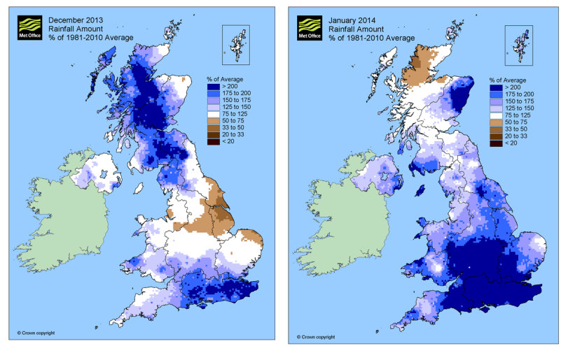
Official Met Office figures show this winter brought with it one of the most exceptional periods of rainfall in England and Wales in at least 248 years, when records began. When the two months are combined, it was the wettest December and January in the UK as a whole since 1910.
The rainfall has hit the south fastest. In January, parts of the southern England received more than 200 per cent of the average rainfall for the month – shown in dark blue in the maps below.
Total rainfall (mm) for January in southern England from records going back to 1910 (top panel), and the number of days with rain (>1mm) in southern England from records going back to 1961 (bottom panel). You can see January 2014 on the far right. (Met Office)
What’s behind all the rainfall? A sequence of low pressure weather systems coming across the Atlantic – with the UK sitting right in their path, according to the Met Office report.
The Met Office explains it’s unusual to see so many severe storms in a short space of time – with major storms hitting the UK on 4th December, again on 5th January and continuing into the first week of February. The report says:
“Although no individual storm can be regarded as exceptional, the clustering and persistence of the storms is highly unusual â?¦ It is this continued run of storms that has created the exceptional flooding conditions experienced in the Somerset Levels, for example.”
Why so stormy?
Storms usually follow a certain pathway across land and ocean, known as a storm track. The position of the storm tracks is largely determined by the jet stream – a thin, fast flowing ribbon of air high up in the atmosphere that acts to steer weather systems towards the UK.
The jet stream was unusually strong in December and January, creating perfect conditions for a sequence of strong storms to weave their way across the Atlantic to the UK, the report explains.
A different jet stream extending across North Africa and the North West Pacific has also showed some unusual movements, which scientists think is contributing to recent storminess in the UK.
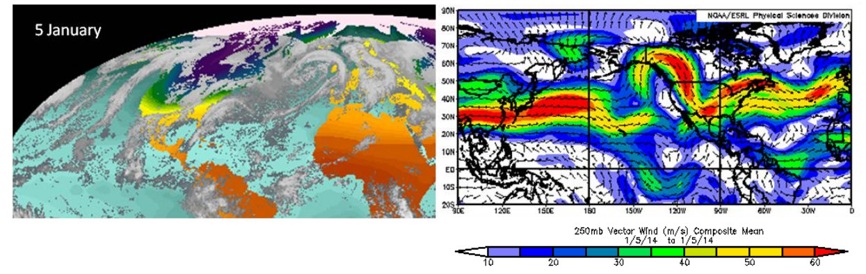
A snapshot of a storm approaching the UK on the 5th January, showing winds up to 60 metres per second (red). Met Office report
The unusual run of weather in the UK isn’t an isolated event, says the Met Office. The new reports links weather systems on both sides of the Atlantic, saying:
“The severe weather in the UK coincided with exceptionally cold weather in Canada and the USA â?¦ There is a strong association with the stormy weather experienced in the UK during December and January and the upstream perturbations to the jet stream over North America and the North Pacific.”
So how much is climate change a factor in what we’re seeing?
Human fingerprint
The new report says there are three things to consider in assessing the role of climate change in past and future storm and flood risk: the number and frequency of storms, the amount of rainfall, and the extra impact of rising sea levels.
There’s some evidence we’re seeing more storms hit the UK over the last century or so. The slope of the red lines in the graphs below suggests the number of winter storms has increased in the North Atlantic between the UK and Iceland – and that those storms are getting stronger.

Source: Wang et al., ( 2012)
Over the UK, there’s also growing evidence that heavy rainfall events are getting more frequent. This fits in with scientists’ understanding of the fundamental physics of a warming world – warmer air carries more moisture, which means that rain falls in heavier bursts.
The Met Office report explains:
“What in the 1960s and 1970s might have been a 1 in 125 day event is now more likely to be a 1 in 85 day event. This supports other evidence that UK rainfall is increasing in intensity.”
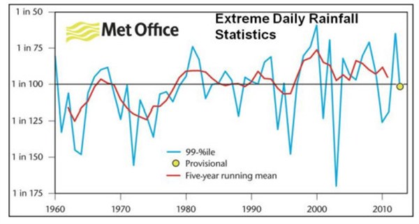
What would have been a 1 in 125 year rainfall event in the 1960s is now more likely to be a 1 in 85 year event. Source: Met Office report.
On top of storminess and rainfall, coastal flood risk is increasing as rising temperatures are causing sea levels to rise. The report says:
“Sea level along the English Channel has already risen during the 20th century due to ocean warming and melting of glaciers. With the warming we are already committed to over the next few decades, a further overall 11-16cm of sea level rise is likely by 2030, relative to 1990, of which at least two-thirds will be due to the effects of climate change.”
Scientists can undertake research which lets them go a step further than saying recent events fit their expectations of a warming climate. By doing what’s known as an ‘attribution study’, it’s possible to say more definitely whether we could have seen the same scale of storms and rainfall in a world that wasn’t warming.
These sorts of analyses are very complicated, rely on sophisticated computer modelling, and take a while. It’s likely to be some time before researchers can determine if climate change is the reason for the unusual excursions of the jet stream – the immediate cause of our recent run of weather.
The Met Office says:
“This is a critical question because it raises the possibility that disruption of our usual weather patterns may be how climate change manifests itself â?¦ As yet, there is no definitive answer on the possible contribution of climate change to the recent storminess, rainfall amounts and the consequent flooding â?¦ It’s only now that the climate models are reaching a level of detail and skill that is necessary to address the issues raised by recent events.”
Preparing for the future
The bottom line from the Met Office is that the sequence of severe storms we’ve seen recently is highly unusual, and may be influenced by a warming climate changing atmospheric circulations.
The heavy rain those storms have been depositing also fits in with what scientists broadly expect from climate change. Formal attribution studies are yet to confirm exactly how much of what we’re seeing is down to human influence on the climate, but the report makes it plain on many counts that we should be making ourselves more resilient to flooding in the future.
—————————–
Updated 11th February - The Met Office issued a correction clarifying the projections for sea level rise in the channel by 2030 are relative to 1990 levels. We have updated the quote in the blog.