The Pacific weather phenomenon known as El Niño looks to be firmly on its way. After a slow start, forecasters yesterday confirmed an El Niño should be making an appearance in the next month or two, though it’s likely to be a weak one.
Pacific fluctuations
Every five years or so, a change in the winds causes a shift to warmer than normal ocean temperatures in the equatorial Pacific Ocean – known as El Niño, or cooler than normal – known as La Niña, moving briefly back to normal in between.
The warm and cool phases together are known as the El Niño Southern Oscillation (ENSO), and are responsible for most of the fluctuations in global weather we see from one year to the next.
Each time a switch occurs, changes in the ocean and atmosphere above affect global temperature and rainfall patterns worldwide.
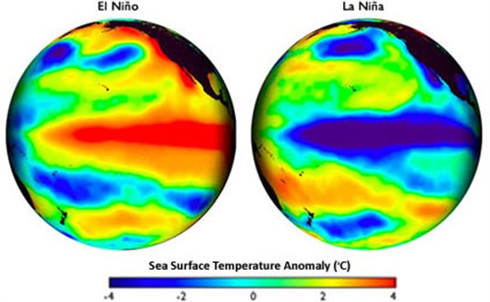
Sea surface temperature during El Niño (left) and La Niña (right). Red and blue show warmer and cooler temperatures than the long term average. [Credit: Steve Albers, NOAA]
El Niño watch
Forecasters at the US National Oceanic and Atmospheric Administration (NOAA) have been keeping a close eye on conditions in the Pacific, updating their predictions every month.
The latest forecast from scientists is that we should expect El Niño to make an appearance within the next one or two months, and last through till Spring.
Technically, an El Niño is characterised by sea surface temperatures reaching 0.5 degrees Celsius above the long term average. Right now, they’re about up by 0.3 degrees.
NOAA adds that the imminent El Niño is expected to be a weak one throughout its duration, similar to the 2009/10 event during which sea surface temperatures peaked at 1.6 degrees above normal. For comparison, the 1997/8 record El Niño anomaly reached 2.4 degrees.
Evolving forecast
September’s forecast put the chances of an El Niño developing in Northern Hemisphere Autumn or Winter at about 65 per cent. This month’s forecast is essentially unchanged, saying:
“The consensus of forecasters indicates 2-in-3 chance of El Niño during the November 2014 – January 2015 season.”

Two thirds of models predict El Niño will begin in October, November or December (OND). This is when sea surface temperatures rise 0.5 degrees Celsius above normal. Colours are different models. Source: NOAA’s National Weather Service
Back in January, forecasters were predicting a 90 per cent chance of seeing El Niño by the end of the year but began scaling back their predictions in August after the atmosphere had “largely failed to respond” as expected. As NOAA scientist, Michelle L’Heureux, described it:
“Waiting for El Niño is starting to feel like Waiting for Godot.”
News of El Niño’s imminent arrival may come as a relief in some parts of the world. Almost 60 per cent of California is currently experiencing ‘exceptional’ drought, for example.
But in others, El Niño is likely to bring widespread destructive weather and damage to crop yields. Indonesia and Australia typically see below average rainfall, with high temperatures increasing the risk of bushfires and heatwaves.
All eyes are on the Pacific as countries watch to see how this year’s El Niño develops, and prepare for the consequences.