Arctic sea ice summer minimum in 2019 is ‘joint-second lowest’ on record
Arctic sea ice has reached its summer minimum extent for 2019, measuring in at 4.15m square kilometers (km2). This puts this year joint-second lowest in the 40-year satellite record, tied with 2007 and 2016.
The thirteen smallest summer lows for Arctic sea ice in the satellite record have all occurred in the last thirteen years.
The provisional announcement, from the National Snow and Ice Data Center (NSIDC) in the US, could change if shifting winds or late-season melt reduces the sea ice extent further.
Melt season
As the northern hemisphere summer comes to an end, the annual retreat of Arctic sea ice slows to a stop before ice starts accumulating again. This point is marked each year as the summer minimum and used as an indicator for the health of Arctic sea ice.
Satellite data indicate that Arctic sea ice hit its annual minimum on 18 September. This is “four days later than the 1981-to-2010 median minimum date of 14 September”, the NSIDC says.
The 2019 summer low of 4.15m km2 is the joint-second smallest in the satellite record that goes back to the late 1970s. This year is “effectively tied” with 2007 and 2016, according to the NSIDC, and beaten only by the record low in 2012 of 3.39m km2. The 2019 figure is 2.1m km2 below the average summer minimum extent for 1981-2010.
The white shading in the map below shows the summer minimum sea ice extent for this year. The orange line shows the long-term average extent for the same day.
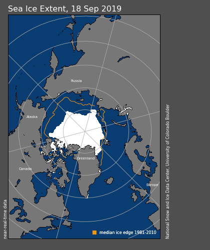
Another low summer minimum this year means that the “13 lowest extents in the satellite era have all occurred in the last 13 years”, the NSIDC says.
Record-breaking summer
The chart below shows how sea ice retreat since May in 2019 (blue line) compares with the two years it is tied with – 2016 (brown) and 2007 (light brown) – as well as 2012 (dotted pink and the long-term average (grey).
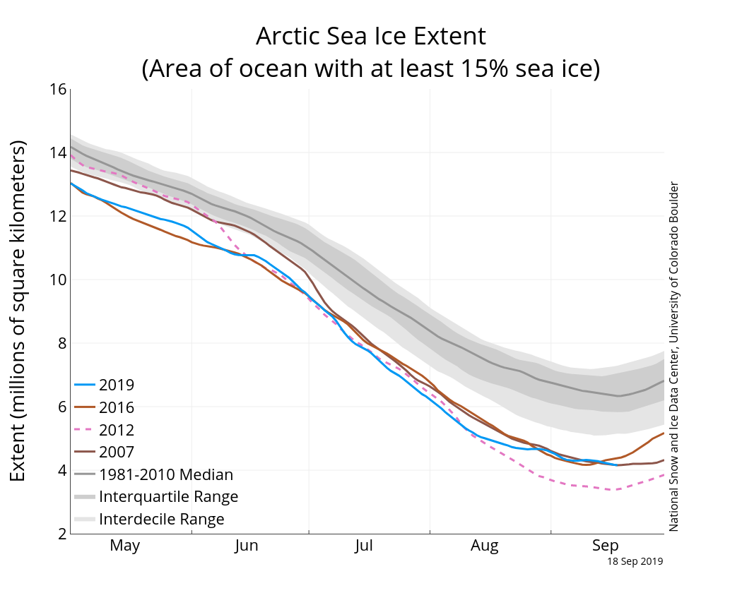
What is particularly interesting this year is that “for part of the summer the ice was tracking below that in 2012”, says Prof Julienne Stroeve, professor of polar observation and modelling at University College London and senior research scientist at the NSIDC.
In fact, after the winter maximum in March – the seventh smallest on record – Arctic sea ice quickly began tracking at record low levels for the time of year.
Average Arctic sea ice for April and July set new low records for those months. “May and August in 2019 were the warmest on record for the Arctic,” Stroeve tells Carbon Brief.
And “yet we didn’t have a new record low”, she says. “This shows that extreme events – such as the 2012 cyclone – are important to whether or not a new record low is achieved,” she adds, referring to a storm that contributed to a “rapid pace of ice loss” in the summer of 2012. (Research has since suggested that 2012 would have been a record low even without the cyclone.)
‘Increasingly sensitive’
The summer of 2019 was “characterised by an Arctic dipole anomaly pattern of sea level pressure”, explains Zack Labe, a University of California PhD student studying sea ice. He tells Carbon Brief:
“This essentially means that an area of higher pressure was found on the Canadian side of the Arctic, while a lower pressure was found on the Siberian side of the Arctic.”
This “dipole” weather pattern has a tendency to accelerate sea ice melting and increase the movement of sea ice out into the Atlantic Ocean, says Labe. The sea ice is pushed out of the Fram Strait – the passage between Greenland and Svalbard – and, hence, is called “Fram export”.
So, while sea ice extent was at or close to a record low until mid-August, a “weakening of the dipole pattern” saw a “switch to stormier/colder conditions over the Arctic”, says Labe. “This allowed 2012 to take the lead,” he adds.
Such a slowdown in sea ice retreat during this time suggests that “the thinner sea ice cover is now increasingly sensitive to changes in synoptic weather conditions”, notes Labe.
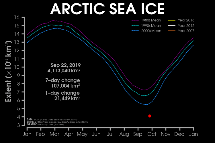
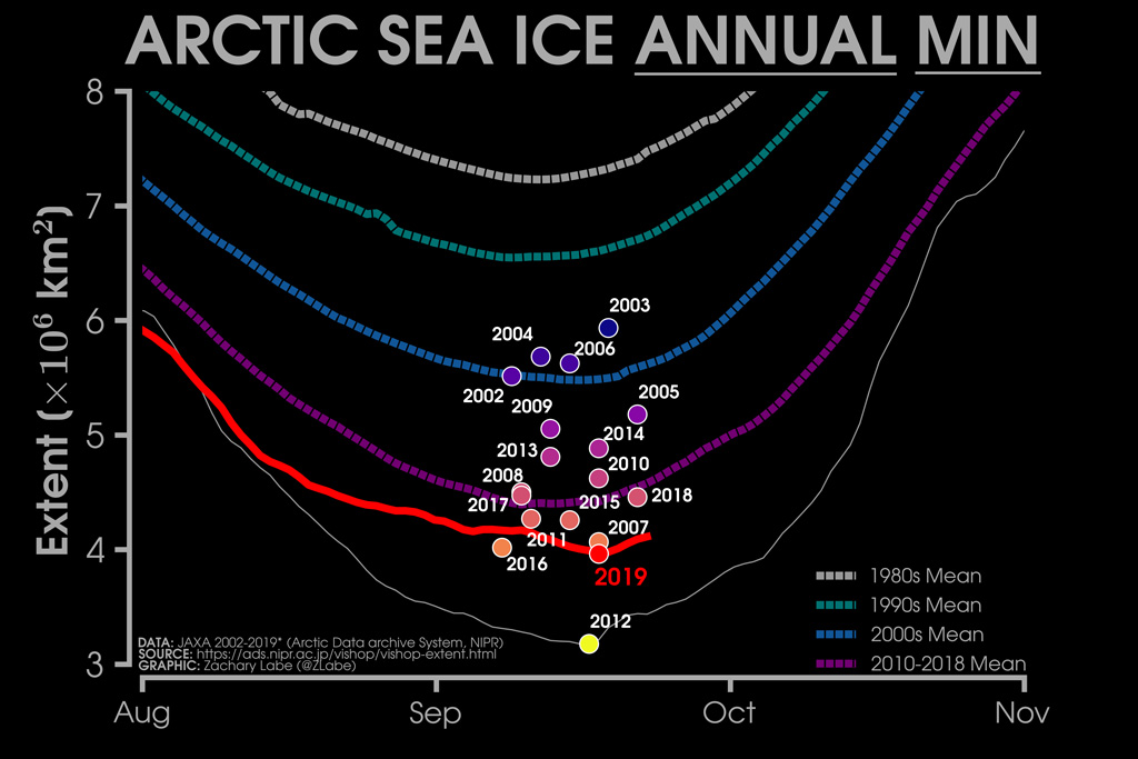
The chart below, produced by Labe, shows how Arctic sea ice summer retreat in 2019 (red line) compares to 2012 (white). It also shows the annual minima for all years since 2002.
Labe has also produced an animation of the 2019 Arctic sea ice extent (red line), compared with 2018 (yellow), 2007 (brown) and 2010 (white) for the whole calendar year. The chart also shows decadal average extents for the 1980s (purple), 1990s (green) and 2000s (blue).