Guest post: The underappreciated influence of the tropics on the ‘jet stream’

Prof Tim Woollings
03.09.20Prof Tim Woollings
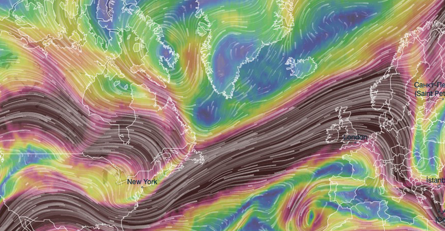
09.03.2020 | 11:38amOver the past decade or so, a scientific debate has emerged around whether rapid Arctic warming could be affecting extreme weather in the mid-latitudes. Much of this work focuses on the jet stream – the narrow current of strong winds encircling the globe around 40-50 degrees North.
The science is far from settled. The jet stream can vary wildly from week to week, or from year to year, and questions remain over whether any signal from the Arctic can yet be seen over the background “noise” of natural variability. (The latest study on the topic, for example, suggests the link is “insignificant”.)
The current winter provides an interesting, if trivial, example. In the Arctic, the steady decline of sea ice continues, with the January 2020 average extent among the lowest 10 years in the satellite record. According to some of the most widely reported theories, we might expect the jet to have been weaker and more “wavy” this winter as a result. But the reality is quite the opposite. So far this season, the jet has mostly been strong and straight, bringing mild and stormy weather to much of northern Europe.
Of course, lots of this is just ‘weather’ – we expect a certain randomness in the jet stream – and this is a key reason why influences, such as Arctic warming, are so hard to pin down. But, intriguingly, the jet this winter seems to have been highly predictable, with early warnings of such a pattern first being made in the autumn.
We cannot say for certain what has caused this yet, but most meteorological eyes are directed away from the Arctic, towards the south. And, in fact, there is possibly an even more important influence on our weather under a changing climate: the tropics.
Hadley
Ultimately, the jet stream derives its energy from the contrast in temperatures between the warm air over the equator and the cold conditions of the Arctic. And is it intimately tied to conditions in the tropics.
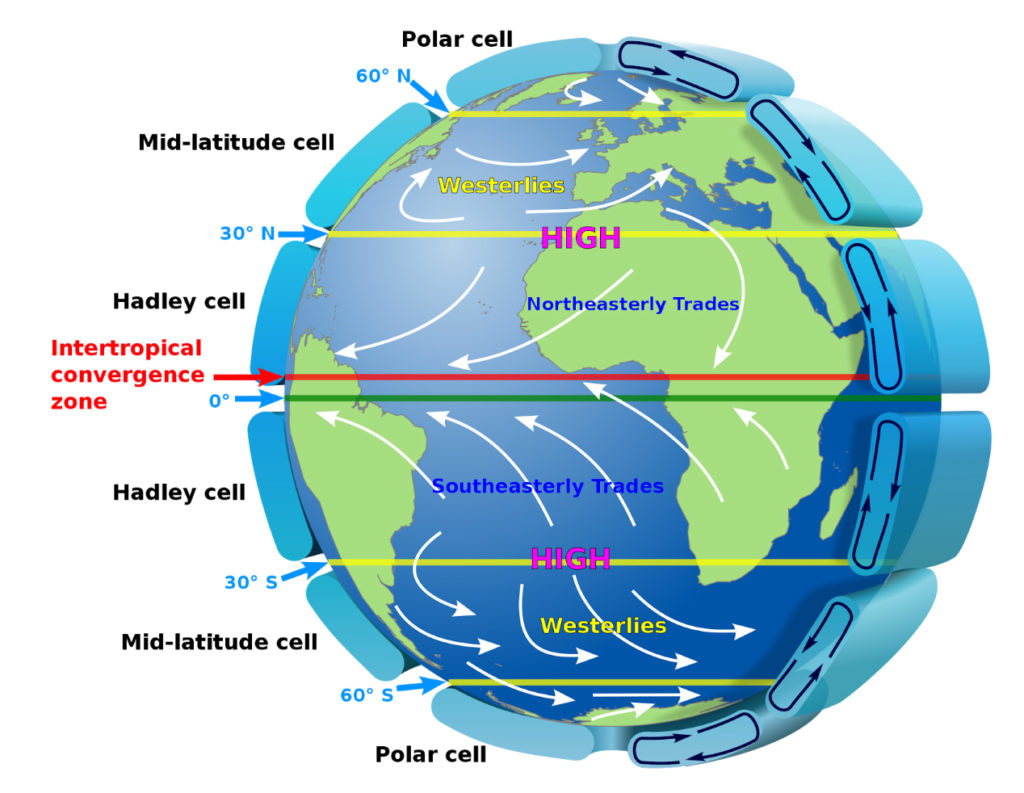
Blessed with a surplus of energy pouring in from the sun, the tropics are in many ways the powerhouse of the Earth’s climate. Somewhere near the equator, depending on season, the surface will face directly towards the sun and so the air here will be heated more than anywhere else, becoming lighter and rising upwards as a result. This forms a giant convection cell in the atmosphere, known as the Hadley cell, with air rising above the equator before moving away, to both the north and south, and then sinking again.
George Hadley was a London lawyer, pondering science questions in his spare time, when he hit upon the basic mechanism explaining the “trade winds”. These are the year-round east-to-west winds that blow across the tropics, on which traders sailing across the Atlantic relied for a swift passage to the Americas. Hadley described the theory in his seminal paper, published by the Royal Society in 1735.
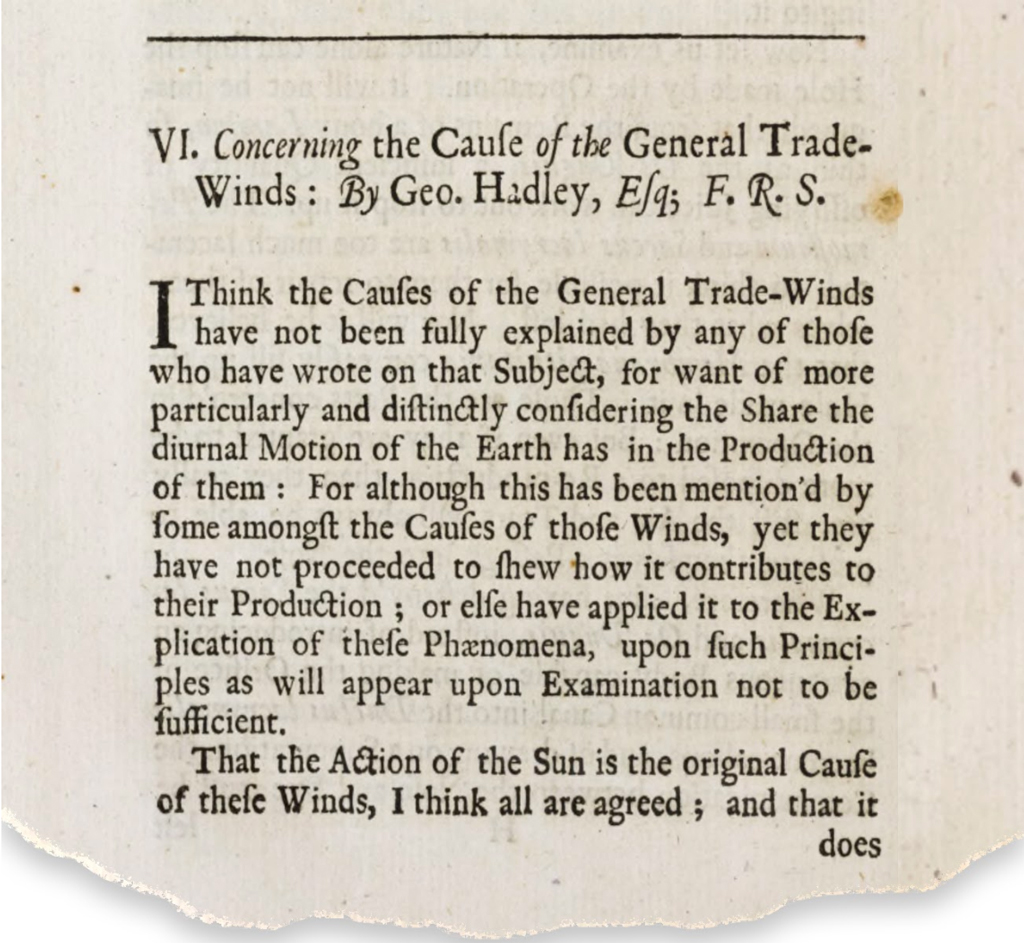
Hadley first theorised the existence of the cell which now bears his name and also that the near-surface air moving towards the equator would be turned by the rotation of the Earth, forming the trade winds. He also predicted that, on the flip side of his cell, there should be strong winds blowing from west to east far above the surface, which he named the “anti-trades”. Today, of course, we call this the jet stream.
(Cartoons of the atmosphere typically feature two jets, one linked to the Hadley cell and one further north linked to a much weaker feature called the polar cell. Although this picture is useful, the two jets are, in reality, often merged into one dominant structure in the mid-latitudes, simply referred to as the jet stream.)
Tropical changes
While scientists are still pondering how variations in the Arctic may affect the jet, the influence of the tropics is abundantly clear.
We need look no further than the dramatic weather disruption caused by El Niño events in the Pacific Ocean, when the balance between the tropical trade winds and the warm equatorial ocean currents is upset. By shifting the locations of the powerful convection driving the Hadley cell, these events send “waves” along the jet stream that can temporarily alter weather patterns around much of the world.
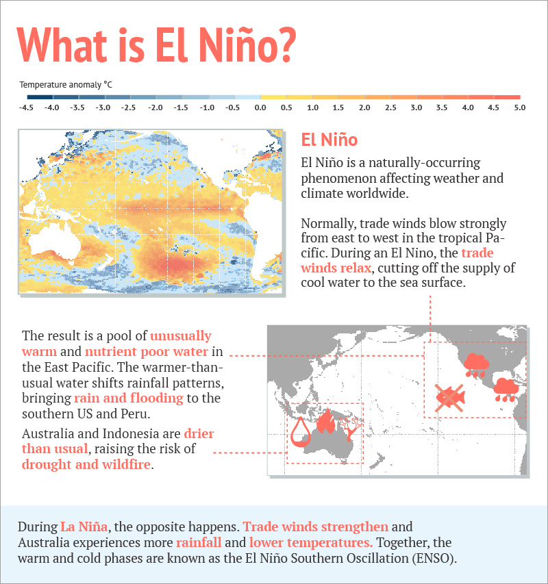
El Niño is the poster-child of climate variability, responsible for much of the skill in our long-range “seasonal” forecasts, which aim to predict average conditions for the season ahead. But there is more to the tropics than just El Niño. The tropical atmosphere is much less stable than that over the Arctic, enabling powerful storm systems to reach up and shunt around air masses up at the heights where the jet is strongest.
For example, it seems likely that weather patterns in the tropics have helped to nudge the jet into its strong and straight configuration this winter, and it is this signal which enabled early warnings for Europe in the autumn of 2019. Specifically, this year’s events are quite consistent with some previous studies of the influence of Indian Ocean weather patterns on the jet stream.
And what about climate change? Might we be seeing changes in the jet stream already because of how the tropics are responding to warming?
The tropics are indeed changing, although there is more uncertainty over how exactly than there is in the Arctic. For example, George Hadley’s great circulation cell has been expanding over recent decades, its boundaries inching slightly, but detectably, polewards.
While this is exactly the signal we expect to arise from climate change, our best assessment is currently that much of the recent changes reflect natural variations, at least in the northern hemisphere. (In the southern hemisphere, the climate change signal is clearer, especially as it is boosted by the effects of stratospheric ozone depletion.)
Ocean heat
The tropical oceans are, of course, warming, along with most oceans around the world. However, here again there is uncertainty over exactly how.
Climate models generally predict the tropical Pacific will warm most strongly in the east, close to South America, while the observed trends show strongest warming instead in the west. Given the sensitivity to these regions evidenced by El Niño, this discrepancy has serious implications for our ability to predict the details of changing weather patterns.
Some new evidence suggests that the observed pattern of stronger western warming might be a signature of climate change, regardless of what the models say. Given the extent to which the details really matter in the tropical Pacific, however, uncertainty is likely to remain here for some time.
Keeping this uncertainty in mind, though, has the warming of the tropical oceans had any effect on the jet stream yet?
Some of our recent work suggests, potentially, yes. El Niño peaks in the northern hemisphere winter – it was originally named after the infant Jesus by Peruvian fishermen – but it also has important impacts in summer by sending giant, continent-sized waves along the jet stream.
For example, a series of extreme weather events rocked Eurasia in 2010, from the searing Russian heatwave to the torrential Pakistan floods, and it seems the climate dice were loaded for these events by La Niña, the so-called “little sister” to El Niño.
Crucially, the pathway for these influences seems to have shifted and strengthened in recent decades, due to a subtle shift of the jet, so that El Niño and La Niña now affect parts of Eurasia in summer that they did not reach before. This is associated with a subtle southward shift of the jet over southeast Asia, which makes it more sensitive to weather disturbances from over the Pacific.
We have been able to reproduce this change in climate model experiments but – importantly – this occurs only when the observed warming of the tropical oceans and the subsequent influence on the jet is included.
It is early days for this type of research, and many uncertainties remain, but we might just be starting to see an example of how the tropics will affect jet stream variability under climate change.
In any case, both Hadley’s circulation cell and El Niño’s shockwaves demonstrate the power of the tropics over the jet stream. As weather patterns alter in our warming world, those of us in the northern mid-latitudes should be looking nervously to the south at least as much as to the north.
-
Guest post: The underappreciated influence of the tropics on the ‘jet stream’
-
Guest post: How tropical influences on the ‘jet stream’ outweigh those of the Arctic