
Met Office: The UK’s wet and warm winter of 2019-20

Guest authors
04.03.20As the UK begins to see the longer, warmer days of spring, it leaves in its wake a winter that broke records for both temperature and rainfall.
The 2019-20 UK winter – covering the months of December, January and February – saw the highest maximum December temperature and the wettest February on record. Overall, the winter was the UK’s fifth warmest, while it was the warmest on record for Europe as a whole.
In this article, we review the recent winter and the factors that contributed to it. Highlights include:
- The winter of 2019-2020 set records in the UK, including the wettest February and highest maximum December temperature.
- This winter ranked as the warmest European winter on record
- Past records show a trend towards warmer and wetter weather. The winters of 2006-07, 2013-14, 2015-16, 2016-17, 2018-19, and 2019-20 were all in the Top 10 warmest winters in the UK, and 2006-07, 2013-14, 2015-16 and 2019-20 were in the Top 10 wettest years.
- This warm, wet winter was largely driven by a positive phase of the Arctic Oscillation, while it is also consistent with projections for the UK under a warming climate.
Record-topping temperatures
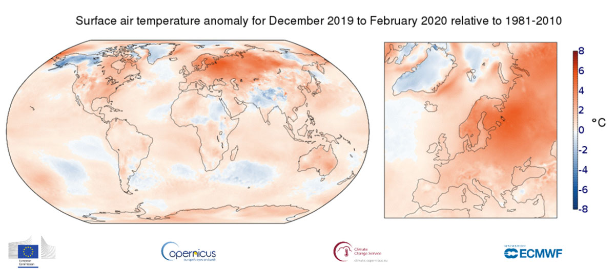
The December-2019-to-February-2020 period saw exceptionally high temperatures across the globe. It was the second warmest December-February period on record for the global average and the warmest for land areas only – sitting 2.04C above the global 20th century land surface average temperature.
This is particularly notable because, unlike the previous record-holding year of 2015-16, this year was not boosted by a warming El Niño event.
As the maps below highlight, much of the northern hemisphere experienced very warm temperatures during this past winter. In fact, it was the northern hemisphere’s second warmest winter on record, while Europe experienced a new record warm winter. Europe’s average temperature of 3.4C above the 1981-2010 average was almost 1.4C higher than its previous warmest winter of 2015-16.
UK temperatures rising
On 28 December 2019, the UK recorded its highest-ever December temperature – 18.7C measured at Achfary (Sutherland). This was due to a Foehn effect – a warming and drying of air on one side of cross-mountain wind – seen during a very mild south westerly air flow.
This record-breaking temperature topped off a warmer-than-average month, which saw an average temperature in December sitting a full 1.3C above the monthly average.
However, December was not the only exceptional month this winter. The UK saw its sixth warmest January in a series from 1884, the wettest February on record and fifth warmest winter.
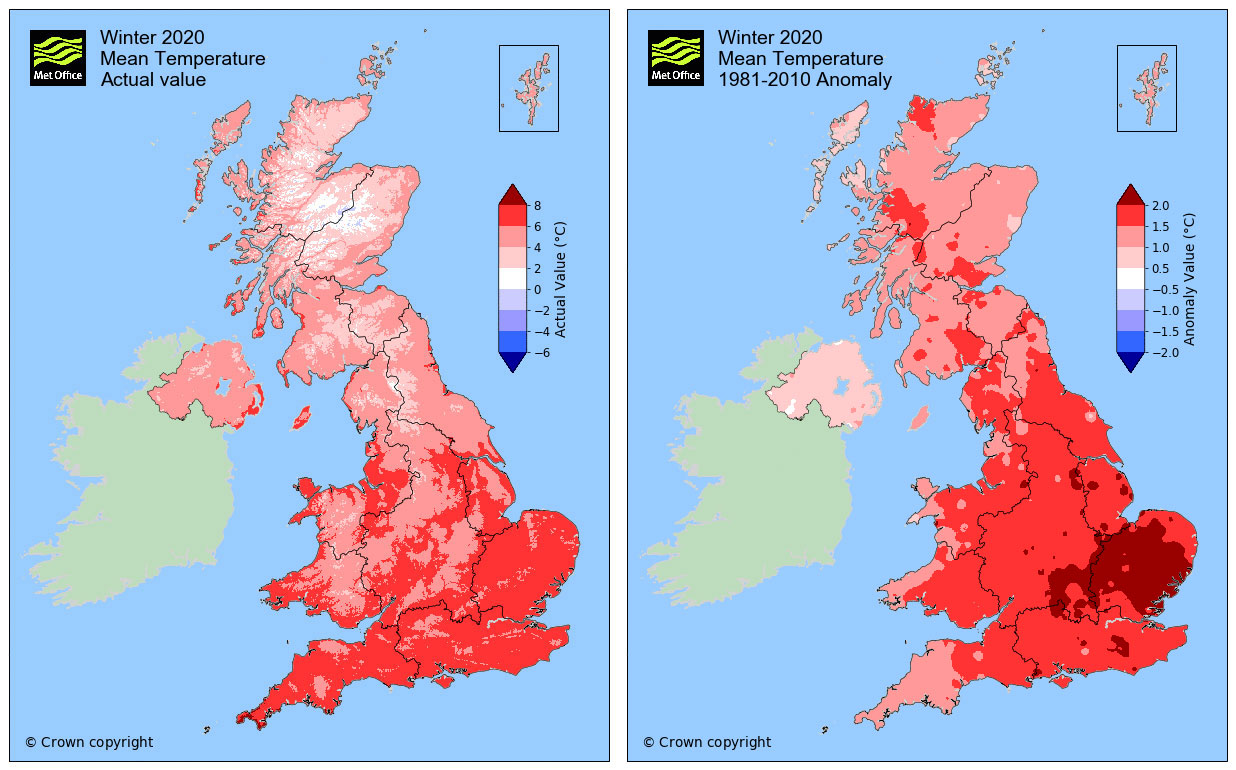
The maps below show the actual average temperature in the UK for the 2019-20 winter (left), and the difference in temperature (anomaly) from the 1981-2010 average (right). The red shading highlights a clear pattern of unusually high temperatures and shows that the average winter temperature was 0C or higher across the entirety of the UK.
Low frost days
This past winter also stands out for its lack of frost days – days when the air temperatures drop below 0C at some point.
Using a series of data starting from 1961, the 2019-20 winter ranks as the third lowest for frost days, with roughly half the number of frost days as the average winter. This winter saw only 19 frost days in the entire three-month period, whilst the average is 36. (These numbers refer to the number of frost days averaged across the whole of the UK, so some regions will have had more and some regions fewer than this.)
It turns out that the maximum, minimum and average temperatures from this winter were all around 1-1.5C above the seasonal normal in most regions across the UK.
Below, the chart shows that the average daily temperature during the winter (dark blue line) occasionally reached or exceeded the 1981-2010 maximum (red), but never got as cold as the 1981-2010 minimum temperature (light blue). The plot also shows that the average daily remained well above zero this winter.
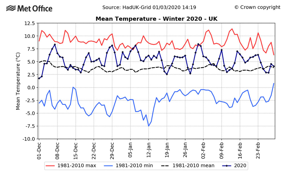
Chart shows daily temperatures for the 2019-20 winter (dark blue line) with 1981-2010 average (black dotted line), maximum (red) and minimum (light blue). Credit: Met Office
Wet February
As well as its unusual warmth, this winter was one of the UK’s wettest winters on record. 470mm of rainfall fell through the winter, amounting to 143% of the 1981-2010 average.
As the map below indicates, the vast majority of the UK saw higher-than-average rainfall (blue shading), with only a few regions along the northeast coast experiencing a drier-than-average winter (brown shading).
Much of this rainfall fell in February, which featured three named storms (Ciara, Dennis and Jorge) and was the fifth wettest month ever recorded in a series going back to 1862.
More than twice the average amount of rainfall fell in February, amounting to 209.1mm of rain. This broke the record for the wettest UK February ever recorded, easily beating the previous record holder of February 1990, which saw 193.4mm of rain.
(See the recent Carbon Brief guest post from the Met Office’s Dr Mark McCarthy for more details.)
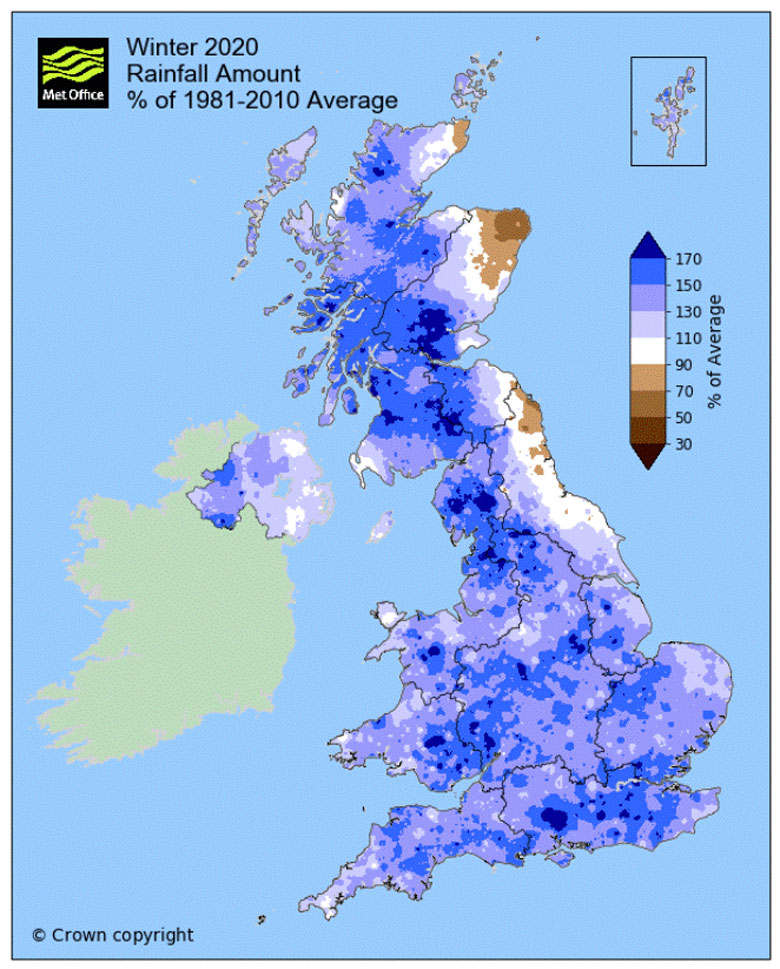
Winter 2019-20 rainfall amounts across the UK, as a percentage of the 1981-2010 average. Shading indicates areas that are wetter (blue) and drier (brown) than the long-term average. Chart: Met Office
A changing climate
This warm wet winter was largely due to large-scale atmospheric dynamics across the north Atlantic, resulting in mild, wet – and, at times, stormy – weather. However, the UK’s weather is also being influenced by a warming climate.
As the planet warms and the average temperature increases, it is easy to focus on the periods of extreme heat which are becoming more frequent and intense. Whilst this is certainly important, it is also noteworthy that extreme cold snaps are becoming less likely, thereby helping the trend of warming winters.
In fact, the winters of 2006-07, 2013-14, 2015-16, 2016-17, 2018-19 and 2019-20 are all in the Top 10 warmest winters on record for the UK in a series from 1884. When taking the average across Europe, six out of the last seven winters are at least 2C above the 1850-1900 baseline.
Rainfall can also be affected by a warming climate, as warmer air is able to hold roughly 7% more moisture per degree of warming. This makes intense rainfall events more likely. As such, 2006-07, 2013-14, 2015-16 and 2019-20 are also all in the Top 10 wettest years.
These changes are in keeping with expectations for the UK as the world warms. The latest projections, provided by the UK Climate Projections 2018 (UKCP18) project, suggest that the UK will see a shift “towards warmer, wetter winters and hotter, drier summers” going forwards.
Predictability
Whilst we can expect a general trend towards warmer and wetter weather due to climate change, natural variability has a significant role to play. One of the most significant factors that can change year on year is the “phase” of the Arctic Oscillation.
The Arctic Oscillation is the single most important atmospheric circulation pattern that affects the climate in the northern hemisphere. It is closely related to its regional equivalent – the North Atlantic Oscillation (NAO) – which plays an important role in UK weather.
In a positive phase of the Arctic Oscillation, the jet stream is stronger and shifts northward, trapping colder temperatures in the Arctic and allowing warmer temperatures to spread across areas such as Europe, the US and East Asia. This was what happened in the winter of 2019-20.
Every month, the Met Office puts out a seasonal forecast – a prediction of weather conditions for the following three months. The forecast from November for sea-level pressure in the winter of 2019-20 (shown below) shows a positive Arctic Oscillation, which diverts the jet stream northward and results in warm temperatures spreading across Europe.
These warm temperatures across Europe are indicated by higher than average pressure (red), whilst colder temperatures north of the jet stream are indicated by lower pressure (dark blue).
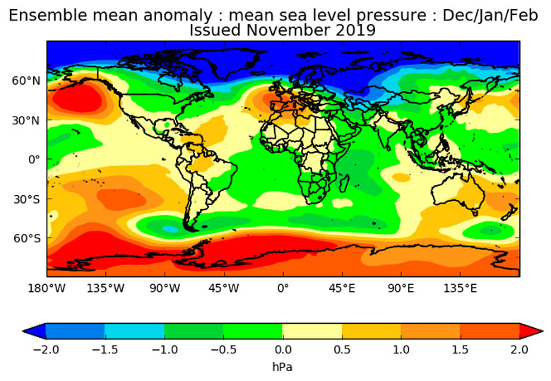
Met Office seasonal forecast for the atmospheric pressure at sea level for December 2019-February 2020. Forecast issued in November 2019. Credit: Met Office
This forecast underpinned the three-month outlook for the winter, which predicted “above-average temperatures” (pdf) and “greater-than-usual likelihood of westerly winds bringing moisture from the Atlantic Ocean to the UK” (pdf).
Acknowledgements: The authors would like to thank their Met Office colleagues Dr Mark McCarthy, Prof Adam Scaife and Dan Williams for their help in producing this article.
-
Met Office: The UK's wet and warm winter of 2019-20
-
A Met Office review of the UK’s wet and warm winter of 2019-20