Africa’s tropical land emitted more CO2 than the US in 2016, satellite data shows
Daisy Dunne
08.13.19Daisy Dunne
13.08.2019 | 4:00pmAfrica’s tropical land released close to 6bn tonnes of CO2 in 2016, according to data taken by satellites.
This means that, if Africa’s tropical regions were a country, it would be the second largest emitter of CO2 in the world – ahead of the US, which currently emits 5.3bn tonnes of CO2 a year.
The region’s 2016 emissions were “unexpectedly large”, the authors write in Nature Communications. This is because the land surface is covered by tropical forests and peatlands, environments which typically absorb large amounts of CO2 from the atmosphere.
The high rate of CO2 loss in 2016 could be associated with a “strong” El Niño, scientists tell Carbon Brief. El Niño is a natural phenomenon that periodically affects weather in many parts of the world. In the African tropics, it can cause unusually high temperatures and drought.
Other causes of CO2 emissions could include “substantial land-use change”, including deforestation and fires associated with agriculture, the study says.
Tropical turmoil
Africa is home to one third of the world’s tropical rainforests. Tropical forests are capable of storing large amounts of CO2. This is because trees absorb carbon from the atmosphere during photosynthesis and then use it to grow new leaves, shoots and roots.
The continent is also home to around 3% of the world’s peatlands, including the world’s most extensive tropical peatland. Peatlands are water-logged environments that can hold huge stores of soil carbon.
Though the African tropics are a globally important carbon store, there have been few studies looking into the extent of year-to-year CO2 emissions from the land in this region.
The new study analyses data taken by two satellites that recorded CO2 emissions stemming from the Africa’s tropical land from 2014-17. These satellites include Japan’s greenhouse gases observing satellite (GOSAT) and NASA’s orbiting carbon observatory (OCO-2).
Data taken from both satellites shows that some parts of tropical Africa’s land are now releasing more CO2 into the atmosphere than they are able to absorb through their trees and soils, says study lead author Prof Paul Palmer, a researcher of geosciences from the University of Edinburgh. He tells Carbon Brief:
“This is a new perspective. Other satellites have reported widespread land degradation over this region but our study is the first to link surface processes to changes in CO2. What the data suggests is that the land is degrading in certain parts of tropical Africa to a point where it is beginning to release carbon.”
Forest flux
The results show that net CO2 emissions from Africa’s tropical land totalled 5.4bn tonnes and 6bn tonnes in 2015 and 2016, respectively. (This figure considers the difference between the amount of CO2 absorbed and emitted by the land.)
Across the tropics as a whole, net CO2 emissions reached 3.8bn tonnes and 5.9bn tonnes in 2015 and 2016, respectively.
This is because the CO2 emissions from tropical Africa were offset by other tropical regions, such as parts of South America, which acted as net removers of CO2 (“carbon sinks”) between 2015 and 2016.
The maps below, taken from the paper’s supplementary information, show the extent of CO2 emissions from tropical land in 2015 and 2016. On the map, dark blue shows regions that acted as carbon sinks while yellow shows regions that were net emitters of CO2.
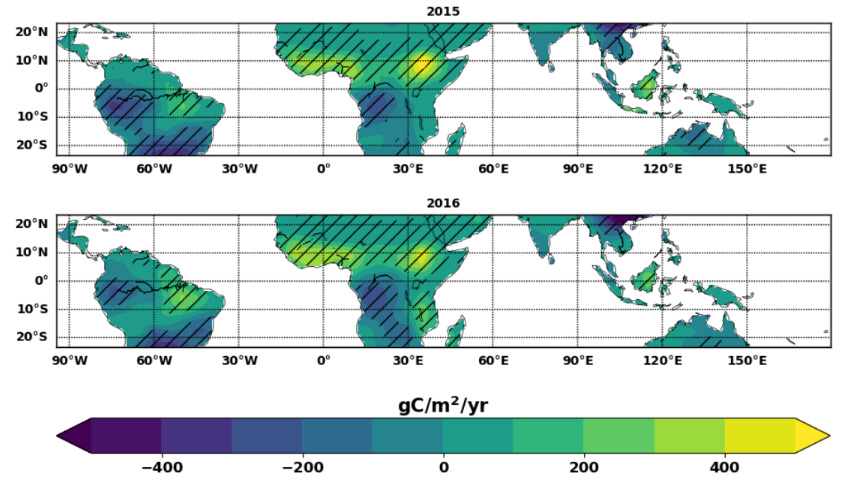
The extent of CO2 emissions from tropical land in 2015 and 2016 in grammes of carbon per metre squared per year (gC/m2/yr). Dark blue shows regions that acted as carbon sinks while yellow shows regions that were net emitters of CO2. Hatching shows regions with lower relative uncertainty. Source: Supplementary Information, Palmer et al. (2019)
The map indicates that the Congo basin acted as a large carbon sink from 2015-16. This region is home to the world’s most extensive tropical peatland, which covers an area larger than the size of England. Research released in 2017 found that the peatland holds the equivalent of 20 years’ worth of fossil fuel emissions from the US.
The maps also show that CO2 losses from Africa were concentrated in western tropical Africa and over parts of Ethiopia.
These regions are home to “large soil carbon stores”, Palmer says. Land degradation and deforestation in these areas could have caused soils to erode and release some of the carbon they hold, he says:
“Substantial changes in land use over a region with high levels of soil organic carbon are conditions that could potentially release carbon from the soils.”
The map below shows the extent of forest loss – a type of land-use change – across tropical Africa in 2018. The data is from the Global Forest Watch, an online forest monitoring service from the World Resources Institute (WRI).
In western Ethiopia, large-scale CO2 loss could be a result of human land-use change and higher than average temperatures, the study says. (Warming can cause soils to release CO2 at a higher rate.) The paper says:
“We find that over western Ethiopia monthly CO2 fluxes increase when temperature rises, and when precipitation and ‘liquid water equivalent thickness’ falls. Western Ethiopia has also experienced extensive and persistent land-use change with significant reductions in above-ground biomass [plant loss] and soil erosion.
“Continued land degradation and warming temperatures could potentially result in a large diffuse CO2 emission source with a temperature dependence.”
‘Troubling’
![]()
The large loss of CO2 in the African tropics was likely influenced by the 2015/16 El Niño, says Prof Oliver Phillips, chair in tropical ecology at the University of Leeds, who was not involved in the study. He tells Carbon Brief:
“The 2015/16 was one of the strongest El Niño events on record. We already know that atmospheric concentrations of CO2 increased faster than ever before in 2016 and that tropical temperatures reached record levels. And other studies have shown that this was boosted in part by emissions from the tropical land.
“The current paper attributes remarkably large emissions to parts of northern tropical Africa which retain very little intact forest. A feature of the 2015-16 El Nino in Africa was sustained warming – and the paper’s suggestion that the large emissions are partly be due to soil carbon stores being [lost] is troubling. It implies a risk of global heating aggravating CO2 emissions within large areas of mostly agricultural land.”
The study “illustrates the point made” by the recent Intergovernmental Panel on Climate Change’s (IPCC) special report on climate change and land, Palmer says.
The report, which was covered in depth by Carbon Brief, found that “land is under growing human pressure and is part of the solution [to climate change] – but land cannot do it all,” according to the IPCC’s chair Hoesung Lee.
![]()
The research “has brought focus to a region of the world we know so little about”, says Dr Pep Canadell, a research scientist and director of the Global Carbon Project, an independent project tracking worldwide emissions of CO2 and other greenhouse gases.
However, the discovery of a large source of CO2 emissions in tropical Africa does not mean that global CO2 emissions are higher than scientists thought, he explains to Carbon Brief:
“Because our carbon budget is a mass balance of sources and sinks constrained by the atmospheric CO2 concentration that we know very well, it means that if a new source appears that was not accounted before, another source might have been overestimated or sinks elsewhere are bigger than we estimated.
“The point being that the carbon burden in the atmosphere is not worse than we thought, just because a new source is discovered.”
Palmer et al. (2019) Net carbon emissions from African biosphere dominate pan-tropical atmospheric CO2 signal, Nature Communications, https://nature.com/articles/s41467-019-11097-w
-
Africa’s tropical land emitted more CO2 than the US in 2016, satellite data shows
-
Africa’s tropical land an ‘unexpectedly large’ CO2 emitter, satellites show