Climate change has driven 16% drop in ‘snow meltwater’ from Asia’s high mountains
Ayesha Tandon
06.24.21Ayesha Tandon
24.06.2021 | 4:00pmClimate change is reducing the supply of water from melting snow to many of the largest rivers in Asia, threatening the water security of millions of people, a new study finds.
Asia is home to the world’s “third pole” – the largest volume of fresh water outside of the polar ice sheets. Melting snowpacks and glaciers from this region feed some of the largest rivers in Asia, which more than a billion people rely on for water. However, as climate change causes melting in the region to accelerate, snow and ice reserves in the area are depleting, leading to worries over water insecurity.
The new study finds that, between 1979-99 and 1999-2019, “snow meltwater supply” to rivers in high-mountain Asia dropped by an average of 16%. It adds that, even if warming is limited to 1.5C, there will be further losses of around 6% by the end of the century. Meanwhile, an extremely high future warming scenario would drive a 40% drop in meltwater supply.
The authors of the paper, which is published in Nature Climate Change, add that although melting glaciers often receive “considerable attention” for their contribution to streamflow, the impact of melting snow is often larger than that of glaciers.
The third pole
Home to the 14 highest peaks on Earth and spanning 10 countries, “high-mountain Asia” is vast. The map below shows the region, including 14 major rivers and their basins – such as the Ganges, the Yellow River and the Yangtze.
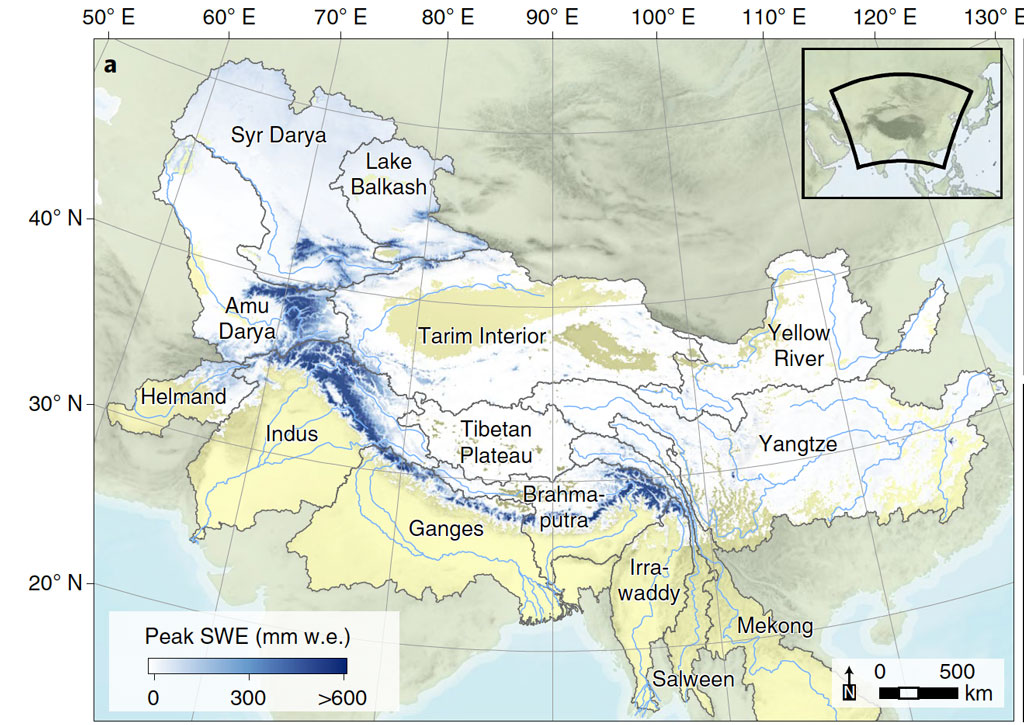
Every year, snow accumulates on the region’s mountain ranges over the winter months, and then melts as the temperature increases over summer. Meltwater from snowpacks feeds into large rivers, which provide water for drinking, washing, agriculture and energy to 1.5 billion people living downstream.
There are three key water sources – snow meltwater, glacial meltwater and rainfall – that keep rivers in the region flowing. All three are important because “the melting of snowpacks and glaciers ensures a constant water supply during dry periods, when rainfall is scarce,” explains Dr Hester Biemans – a scientist at Wageningen University and Research, who was not involved in the study.
However, having warmed 1.8C over the past half century, the Earth’s third pole is also amongst the most sensitive regions on Earth to climate change. Dr Taylor Smith – a researcher in geological remote sensing at the University of Potsdam’s Institute of Geosciences, who was also not involved in the study – tells Carbon Brief that the warmer temperatures are causing snow meltwater seasons to shift, leaving communities more vulnerable to “sporadic” rainfall.
Farmers will be among those affected by changing snowmelt seasons, Biemans adds:
“It is very important to understand how climate change will affect the pattern of water supply in Asia. Many people downstream depend on that water and have also adjusted their pattern of water demand to this temporal pattern of water availability… Farmers might need to find other sources of water, such as groundwater, to water their crops, or change their demand pattern.”
The lead author of the study and assistant professor at Utrecht University – Dr Philip Kraaijenbrink – tells Carbon Brief that due to the “expected strong socioeconomic developments” in the region, water demand is also expected to increase in the coming century, compounding this vulnerability.
The study aims to understand how climate change has already affected snowmelt and how future snowmelt patterns will change in a warming climate. To do this, the authors combine a regional-scale snow model with climate data, satellite snow cover observations and global climate model projections of future warming.
By comparing the 1979-99 average snowmelt with the 1999-2019 average, the authors find a 16% decline in annual snow meltwater across the region. This is mainly caused by increasing temperatures depleting snow reserves, the study says. However, it adds that changing precipitation patterns in the region also play a role in determining snow reserves.
The authors also assess future changes in snowmelt under a range of different emissions scenarios and “shared socioeconomic pathways” (SSPs). In the SSP1-1.9 scenario, which is broadly consistent with limiting global warming to 1.5C, snowmelt will decrease by a further 6% by the end of the century. However, a 40% drop is expected in the most pessimistic scenario – SSP5-8.5 – which would see global temperatures exceed 4C by the end of the century. The study includes a further five scenarios that fall between these two.
Snowmelt seasons
Meltwater seasons are not constant across high-mountain Asia. For this study, the authors group the rivers into four “melt regimes” – short season, long season, late peak and early peak – based on when snow starts to melt. These regimes are generally grouped geographically, because meltwater patterns are based on factors such as mountain altitude and precipitation patterns.
These four regimes are shown below. The solid lines indicate historical snowmelt patterns, and the dashed lines show different future warming pathways, ranging from the low-warming SSP1-1.9 pathway (blue dashed) to the extremely high-warming SSP5-8.5 pathway (dark red dashed). The text on each graph shows which rivers are fed by snow meltwater from that regime.
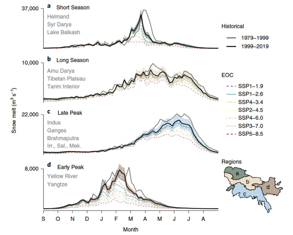
For example, “short season” meltwater comes from snow at low altitudes, the authors explain – because temperatures are warmer at lower altitudes. When spring arrives and the snow starts to melt, processes such as the snow albedo feedback (similar to the better-known “ice albedo feedback”) cause melting to accelerate. This means that rivers fed by “short season” melting snow see large volumes of water in March, but very little for the rest of the year.
Conversely, mountains that feed “late peak” rivers – such as the Ganges – store most of their snow at higher altitudes, where temperatures are cooler. The melting in this regime also starts in March, but it lasts until August, providing a slower, steadier influx of water into rivers downstream.
The study finds that, as the climate warms, the four melt regimes will be affected differently. The plot below shows the percentage change in snowmelt volume for each regime – including historical change, (grey) and seven future warming scenarios for 2100 – ranging from lowest warming (blue) to highest warming (pink).
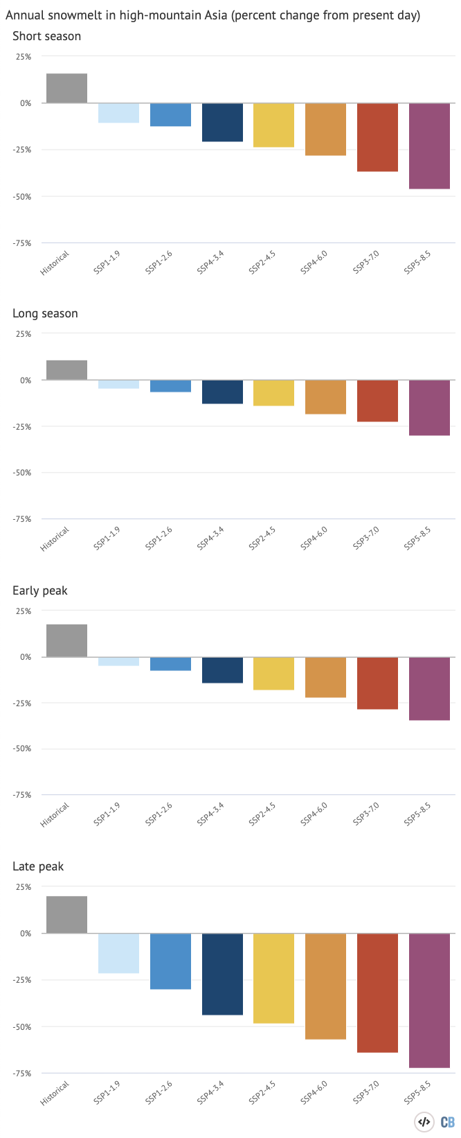
The “early peak” season is the most vulnerable to climate change due to its low-altitude snow, and the study finds that rivers with this regime have already lost an average of one-fifth of their annual snowmelt. The authors add that the regime has already become almost one month shorter, causing the season to start later and end earlier.
Rivers fed by the early peak regime are therefore the most sensitive to future warming. For example, the authors find that the Yellow and Yangtze rivers in China will lose 17% of their snow meltwater contribution for every degree of future warming.
Conversely, high-altitude snow melt is the least affected by climate change. The study finds that in “upper basins” – those that sit above 200 metres in altitude – snowmelt is currently a bigger contributor to streamflow than glacier melt by three to five times.
A river’s dependence on snow meltwater therefore depends on where it is located. The authors find that snow meltwater contributions to the rivers in this study range from 7% for the Yangtze, to 75% for the Amu Darya river.
Measuring melting
While glacial melt and snowmelt are both important contributors to river flow, the paper states that glaciers – slow-moving rivers of ice that form from an accumulation of snow over many years – are better researched. Smith tells Carbon Brief that this is partly because melting glaciers are more high-profile:
“Melting and shrinking glaciers often capture the spotlight as a highly visible sign of climate change; indeed, it is a very short mental leap to go from rising temperatures to shrinking ice. Snow, on the other hand, comes and goes every year with significant variability in timing and depth.”
Kraaijenbrink adds that snowmelt is also more difficult to measure:
“It is difficult to quantify the amount of water stored in snowpacks, particularly in such a large, inaccessible and data-scarce region. This has led to a lack of knowledge about the exact impacts of seasonal snow on downstream water availability in high-mountain Asia and what climate change impacts would be.”
Therefore, instead of using observed data, this study relies on a “temperature-index approach” that considers the relationships between air temperature and snowmelt, and between air temperature and snowfall.
The authors note that the paper provides an “incomplete representation” of snow melt, but say that their method is “the optimal approach”. However, Dr Karl Rittger – a research associate in the Institute of Arctic and Alpine Research at the University of Colorado, who was not involved in the study – cautions that the results are “highly uncertain”.
For example, he tells Carbon Brief, the snow cover data used in the study “is from a model developed in the 1980s and has been shown to perform poorly during the melt season.”.
Prof Jeff Dozier is a snow hydrologist and distinguished professor emeritus and founding dean of the Bren School of Environmental Science & Management at the University of California, and was also not involved in the study. He tells Carbon Brief that he “appreciate[s]” the paper, noting that an “approximate answer” is still useful:
“Applying the analysis to such a huge area requires many approximations, and therefore introduces uncertainties, but we should take the view that an approximate answer to the right question advances the science.”
He adds that the authors have identified potential areas of improvement in the future – including “efforts to fruitfully use satellite imagery to estimate historical snow water equivalent over the past couple of decades”.
Smith tells Carbon Brief that the paper “represents an important step that has not yet been done – knowing which communities will be at risk from reduced snow-water provision will be important for regional water management”.
Kraaijenbrink, P. D A. et al (2021) Climate change decisive for Asia’s snow meltwater supply, Nature Climate Change, doi: 10.1038/s41558-021-01074-x
-
Climate change has driven 16% drop in ‘snow meltwater’ from Asia’s high mountains
-
Snow meltwater is ‘more important contributor’ to Asia’s rivers than glacial melt