Explainer: 'Desertification' and the role of climate change
Desertification has been described as “the greatest environmental challenge of our time” and climate change is making it worse.
While the term may bring to mind the windswept sand dunes of the Sahara or the vast salt pans of the Kalahari, it’s an issue that reaches far beyond those living in and around the world’s deserts, threatening the food security and livelihoods of more than two billion people.
The combined impact of climate change, land mismanagement and unsustainable freshwater use has seen the world’s water-scarce regions increasingly degraded. This leaves their soils less able to support crops, livestock and wildlife.
This week, the Intergovernmental Panel on Climate Change (IPCC) will publish its special report on climate change and land. The report, written by hundreds of scientists and researchers from across the world, dedicates one of its seven chapters solely to the issue of desertification.
Ahead of the report, Carbon Brief looks at what desertification is, the role that climate change plays and what impact it is having around the world.
Defining desertification
In 1994, the UN established the United Nations Convention to Combat Desertification (UNCCD) as the “sole legally binding international agreement linking environment and development to sustainable land management”. The Convention itself was a response to a call at the UN Earth Summit in Rio de Janeiro in 1992 to hold negotiations for an international legal agreement on desertification.
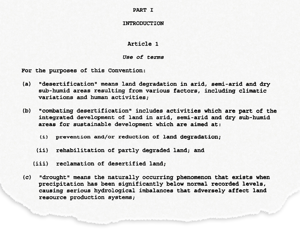
The UNCCD set out a definition of desertification in a treaty adopted by parties in 1994. It states that desertification means “land degradation in arid, semi-arid and dry sub-humid areas resulting from various factors, including climatic variations and human activities”.
So, rather than desertification meaning the literal expansion of deserts, it is a catch-all term for land degradation in water-scarce parts of the world. This degradation includes the temporary or permanent decline in quality of soil, vegetation, water resources or wildlife, for example. It also includes the deterioration of the economic productivity of the land – such as the ability to farm the land for commercial or subsistence purposes.
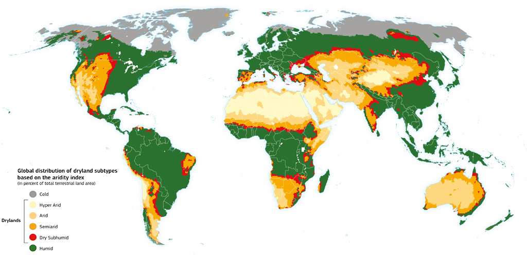
Arid, semi-arid and dry sub-humid areas are known collectively as “drylands”. These are, unsurprisingly, areas that receive relatively little rain or snow each year. Technically, they are defined by the UNCCD as “areas other than polar and sub-polar regions, in which the ratio of annual precipitation to potential evapotranspiration falls within the range from 0.05 to 0.65”.
In simple terms, this means the amount of rainfall the area receives is between 5-65% of the water it has the potential to lose through evaporation and transpiration from the land surface and vegetation, respectively (assuming sufficient moisture is available). Any area that receives more than this is referred to as “humid”.
You can see this more clearly in the map below, where the world’s drylands are identified by different grades of orange and red shading. Drylands encompass around 38% of the Earth’s land area, covering much of North and southern Africa, western North America, Australia, the Middle East and Central Asia. Drylands are home to approximately 2.7 billion people (pdf) – 90% of whom live in developing countries.
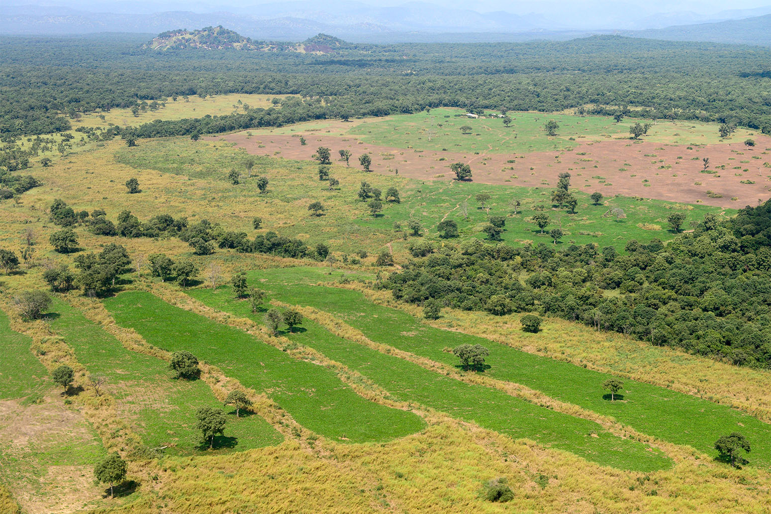
Drylands are particularly susceptible to land degradation because of scarce and variable rainfall as well as poor soil fertility. But what does this degradation look like?
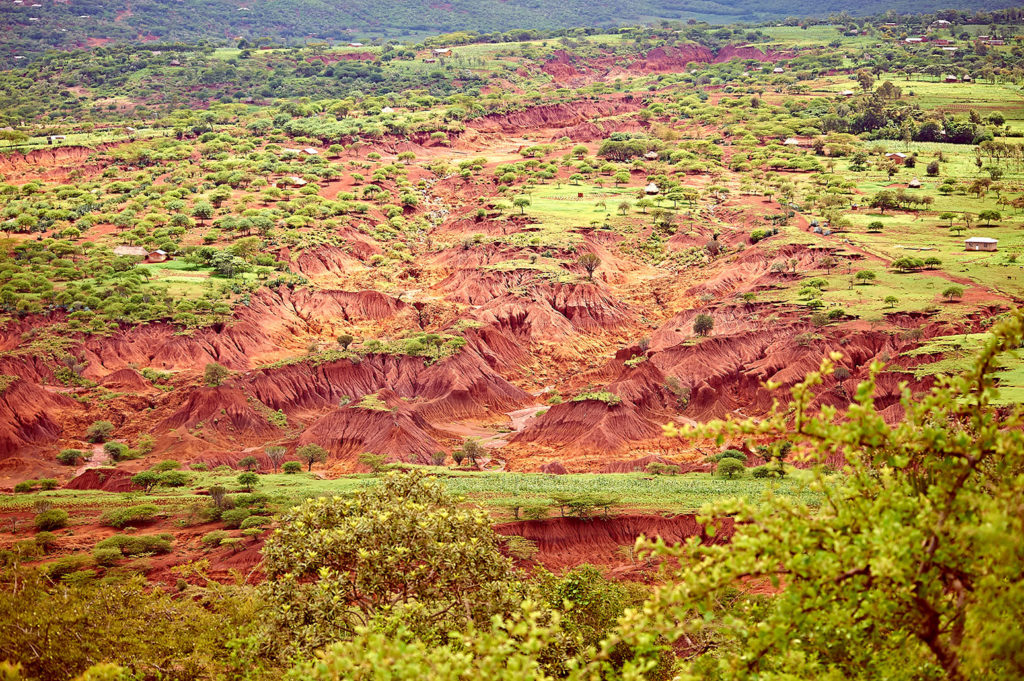
There are numerous ways in which the land can degrade. One of the main processes is erosion – the gradual breaking down and removal of rock and soil. This is typically through some force of nature – such as wind, rain and/or waves – but can be exacerbated by activities including ploughing, grazing or deforestation.
A loss of soil fertility is another form of degradation. This can be through a loss of nutrients, such as nitrogen, phosphorus and potassium, or a decline in the amount of organic matter in the soil. For example, soil erosion by water causes global losses of as much as 42m tonnes of nitrogen and 26m tonnes of phosphorus every year. On farmed land, this inevitably needs to be replaced through fertilisers at significant cost. Soils can also suffer from salinisation – an increase in salt content – and acidification from overuse of fertilisers.
Then there are lots of other processes that are classed as degradation, including a loss or shift in vegetation type and cover, the compaction and hardening of the soil, an increase in wildfires, and a declining water table through excessive extraction of groundwater.
Mix of causes
According to a recent report from the Intergovernmental Science-Policy Platform on Biodiversity and Ecosystem Services (IPBES), “land degradation is almost always the result of multiple interacting causes”.
The direct causes of desertification can be broadly divided between those relating to how the land is – or isn’t – managed and those relating to the climate. The former includes factors such as deforestation, overgrazing of livestock, over-cultivation of crops and inappropriate irrigation; the latter includes natural fluctuations in climate and global warming as a result of human-caused greenhouse gas emissions.
Then there are underlying causes as well, the IPBES report notes, including “economic, demographic, technological, institutional and cultural drivers”.
Looking first at the role of the climate, a significant factor is that the land surface is warming more quickly than the Earth’s surface as a whole. (Recent research shows that this is because the “lapse rate” – the rate that air temperatures decrease with height through the atmosphere – is experiencing larger decreases over the ocean than land. This results in smaller increases in surface ocean temperatures compared to the land surface as global temperatures rise.) So, while global average temperatures are around 1.1C warmer now than in pre-industrial times, the land surface has warmed by approximately 1.7C. The chart below compares changes in land temperatures in four different records with a global average temperature since 1970 (blue line).
Global average land temperatures from four datasets: CRUTEM4 (purple), NASA (red), NOAA (yellow) and Berkeley (grey) for 1970 to the present day, relative to a 1961-90 baseline. Also shown is global temperature from the HadCRUT4 record (blue). Chart by Carbon Brief using Highcharts.While this sustained, human-caused warming can by itself add to heat stress faced by vegetation, it is also linked to worsening extreme weather events, explains Prof Lindsay Stringer, a professor in environment and development at the University of Leeds and a lead author on the land degradation chapter of the forthcoming IPCC land report. She tells Carbon Brief:
“Climate change affects the frequency and magnitude of extreme events like droughts and floods. In areas that are naturally dry for example, a drought can have a huge impact on vegetation cover and productivity, particularly if that land is being used by high numbers of livestock. As plants die off due to lack of water, the soil becomes bare and is more easily eroded by wind, and by water when the rains do eventually come.”
(Stringer is commenting here in her role at her home institution and not in her capacity as an IPCC author. This is the case with all the scientists quoted in this article.)
Both natural variability in climate and global warming can also affect rainfall patterns around the world, which can contribute to desertification. Rainfall has a cooling effect on the land surface, so a decline in rainfall can allow soils to dry out in the heat and become more prone to erosion. On the other hand, heavy rainfall can erode soil itself and cause waterlogging and subsidence.
For example, widespread drought – and associated desertification – in the Sahel region of Africa in the second half of the 20th century has been linked to natural fluctuations in the Atlantic, Pacific and Indian Oceans, while research also suggests a partial recovery in rains was driven by warming sea surface temperatures in the Mediterranean.
Dr Katerina Michaelides, a senior lecturer in the Drylands Research Group at the University of Bristol and contributing author on the desertification chapter of the IPCC land report, describes a shift to drier conditions as the main impact of a warming climate on desertification. She tells Carbon Brief:
“The main effect of climate change is through aridification, a progressive change of the climate towards a more arid state – whereby rainfall decreases in relation to the evaporative demand – as this directly affects water supply to vegetation and soils.”
Climate change is also a contributing factor to wildfires, causing warmer – and sometimes drier – seasons that provide ideal conditions for fires to take hold. And a warmer climate can speed up the decomposition of organic carbon in soils, leaving them depleted and less able to retain water and nutrients.
As well as physical impacts on the landscape, climate change can impact on humans “because it reduces options for adaptation and livelihoods, and can drive people to overexploit the land”, notes Stringer.
That overexploitation refers to the way that humans can mismanage land and cause it to degrade. Perhaps the most obvious way is through deforestation. Removing trees can upset the balance of nutrients in the soil and takes away the roots that helps bind the soil together, leaving it at risk of being eroded and washed or blown away.
Forests also play a significant role in the water cycle – particularly in the tropics. For example, research published in the 1970s showed that the Amazon rainforest generates around half of its own rainfall. This means that clearing the forests runs the risk of causing the local climate to dry, adding to the risk of desertification.
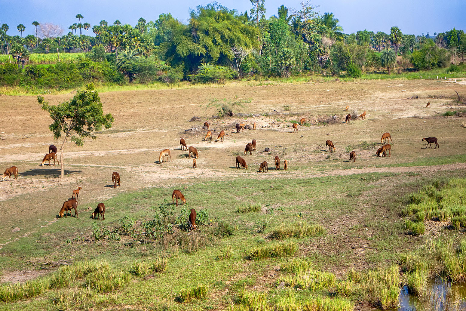
Food production is also a major driver of desertification. Growing demand for food can see cropland expand into forests and grasslands, and use of intensive farming methods to maximise yields. Overgrazing of livestock can strip rangelands of vegetation and nutrients.
This demand can often have wider political and socioeconomic drivers, notes Stringer:
“For example, demand for meat in Europe can drive the clearance of forest land in South America. So, while desertification is experienced in particular locations, its drivers are global and coming largely from the prevailing global political and economic system.”
Local and global impacts
Of course, none of these drivers acts in isolation. Climate change interacts with the other human drivers of degradation, such as “unsustainable land management and agricultural expansion, in causing or worsening many of these desertification processes”, says Dr Alisher Mirzabaev, a senior researcher at the University of Bonn and a coordinating lead author on the desertification chapter of the IPCC land report. He tells Carbon Brief:
“The [result is] declines in crop and livestock productivity, loss of biodiversity, increasing chances of wildfires in certain areas. Naturally, these will have negative impacts on food security and livelihoods, especially in developing countries.”
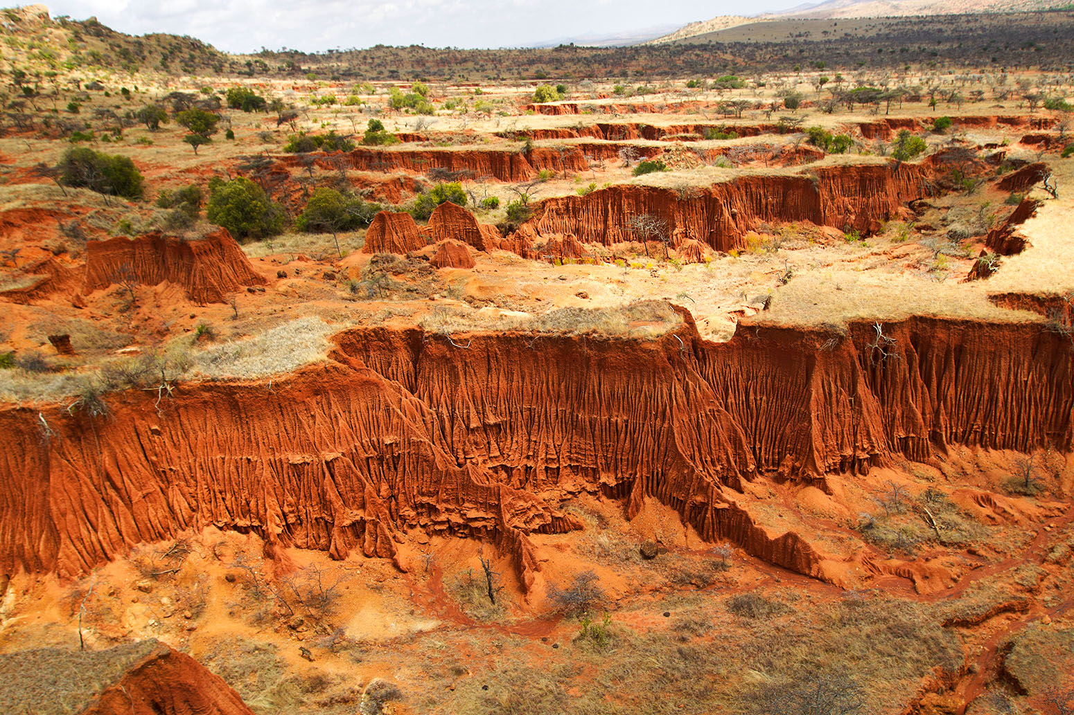
Stringer says desertification often brings with it “a reduction in vegetation cover, so more bare ground, a lack of water, and soil salinisation in irrigated areas”. This also can mean a loss of biodiversity and visible scarring of the landscape through erosion and the formation of gullies following heavy rainfall.
“Desertification has already contributed to the global loss of biodiversity”, adds Joyce Kimutai from the Kenya Meteorological Department. Kimutai, who is also a lead author on the desertification chapter of the IPCC land report, tells Carbon Brief:
“Wildlife, especially large mammals, have limited capacities for timely adaptation to the coupled effects of climate change and desertification.”
For example, a study (pdf) of the Cholistan Desert region of Pakistan found that the “flora and fauna have been thinning out gradually with the increasing severity of desertization”. And a study of Mongolia found that “all species richness and diversity indicators declined significantly” because of grazing and increasing temperatures over the last two decades.
Degradation can also open the land up to invasive species and those less suitable for grazing livestock, says Michaelides:
“In many countries, desertification means a decline in soil fertility, a reduction in vegetation cover – especially grass cover – and more invasive shrub species. Practically speaking, the consequences of this are less available land for grazing, and less productive soils. Ecosystems start to look different as more drought tolerant shrubs invade what used to be grasslands and more bare soil is exposed.”
This has “devastating consequences for food security, livelihoods and biodiversity”, she explains:
“Where food security and livelihoods are intimately tied to the land, the consequences of desertification are particularly immediate. Examples are many countries in East Africa – especially Somalia, Kenya and Ethiopia – where over half of the population are pastoralists relying on healthy grazing lands for their livelihoods. In Somalia alone, livestock contributes around 40% of the GDP [Gross Domestic Product].”
The UNCCD estimates that around 12m hectares of productive land are lost to desertification and drought each year. This is an area that could produce 20m tonnes of grain annually.
This has a considerable financial impact. In Niger, for example, the costs of degradation caused by land use change amounts to around 11% of its GDP. Similarly in Argentina, the “total loss of ecosystem services due to land-use/cover change, wetlands degradation and use of land degrading management practices on grazing lands and selected croplands” is equivalent to about 16% of its GDP.
Loss of livestock, reduced crop yields and declining food security are very visible human impacts of desertification, says Stringer:
“People cope with these kinds of challenges in various ways – by skipping meals to save food; buying what they can – which is difficult for those living in poverty with few other livelihood options – collecting wild foods, and in extreme conditions, often combined with other drivers, people move away from affected areas, abandoning the land.”
People are particularly vulnerable to the impacts of desertification where they have “insecure property rights, where there are few economic supports for farmers, where there are high levels of poverty and inequality, and where governance is weak”, Stringer adds.
Another impact of desertification is an increase in sand and dust storms. These natural phenomena – known variously as “sirocco”, “haboob”, “yellow dust”, “white storms”, and the “harmattan” – occur when strong winds blow loose sand and dirt from bare, dry soils. Research suggests that global annual dust emissions have increased by 25% between the late nineteenth century and today, with climate change and land use change the key drivers.
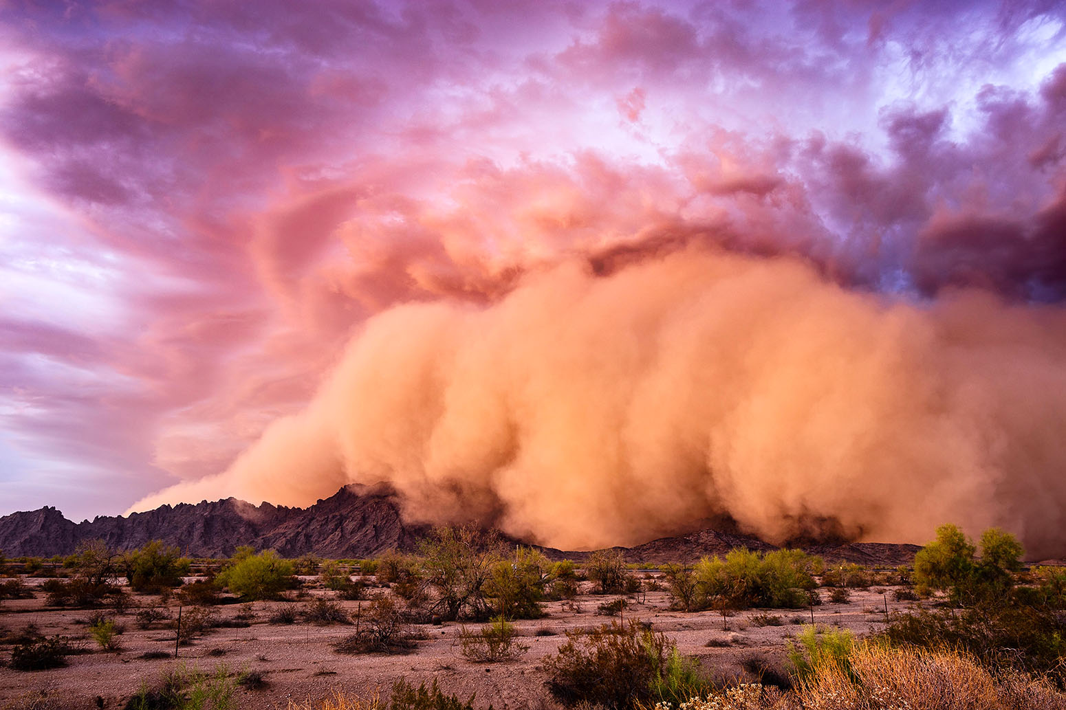
Dust storms in the Middle East, for example, “are becoming more frequent and intense in recent years”, a recent study found. This has been driven by “long-term reductions in rainfall promot[ing] lower soil moisture and vegetative cover”. However, Stringer adds that “further research is needed to establish the precise links between climate change, desertification and dust and sandstorms”.
Dust storms can have a huge impact on human health, contributing to respiratory disorders such as asthma and pneumonia, cardiovascular issues and skin irritations, as well as polluting open water sources. They can also play havoc with infrastructure, reducing the effectiveness of solar panels and wind turbines by covering them in dust, and causing disruption to roads, railways and airports.
Climate feedback
Adding dust and sand into the atmosphere is also one of the ways that desertification itself can affect the climate, says Kimutai. Others include “changes in vegetation cover, surface albedo (reflectivity of the Earth’s surface), and greenhouse gases fluxes”, she adds.
Dust particles in the atmosphere can scatter incoming radiation from the sun, reducing warming locally at the surface, but increasing it in the air above. They can also affect the formation and lifetimes of clouds, potentially making rainfall less likely and thus reducing moisture in an already dry area.
Soils are a very important store of carbon. The top two metres of soil in global drylands, for example, store an estimated 646bn tonnes of carbon – approximately 32% of the carbon held in all the world’s soils.
Research shows that the moisture content of the soil is the main influence on the capacity for dryland soils to “mineralise” carbon. This is the process, also known as “soil respiration”, where microbes break down the organic carbon in the soil and convert it to CO2. This process also makes nutrients in the soil available for plants to use as they grow.
Soil respiration indicates the soil’s ability to sustain plant growth. And typically, respiration declines with decreasing soil moisture to a point where microbial activity effectively stops. While this reduces the CO2 the microbes release, it also inhibits plant growth, which means the vegetation is taking up less CO2 from the atmosphere through photosynthesis. Overall, dry soils are more likely to be net emitters of CO2.
So as soils become more arid, they will tend to be less able to sequester carbon from the atmosphere, and thus will contribute to climate change. Other forms of degradation also generally release CO2 into the atmosphere, such as deforestation, overgrazing – by stripping the land of vegetation – and wildfires.
Mapping troubles
“Most dryland environments around the world are being affected by desertification to some extent,” says Michaelides.
But coming up with a robust global estimate for desertification is not straightforward, explains Kimutai:
“Current estimates of the extent and severity of desertification vary greatly due to missing and/or unreliable information. The multiplicity and complexity of the processes of desertification make its quantification even more difficult. Studies have used different methods based on different definitions.”
And identifying desertification is made harder because it tends to emerge relatively slowly, adds Michaelides:
“At the start of the process, desertification may be hard to detect, and because it’s slow it may take decades to realise that a place is changing. By the time it is detected, it may be hard to halt or reverse.”
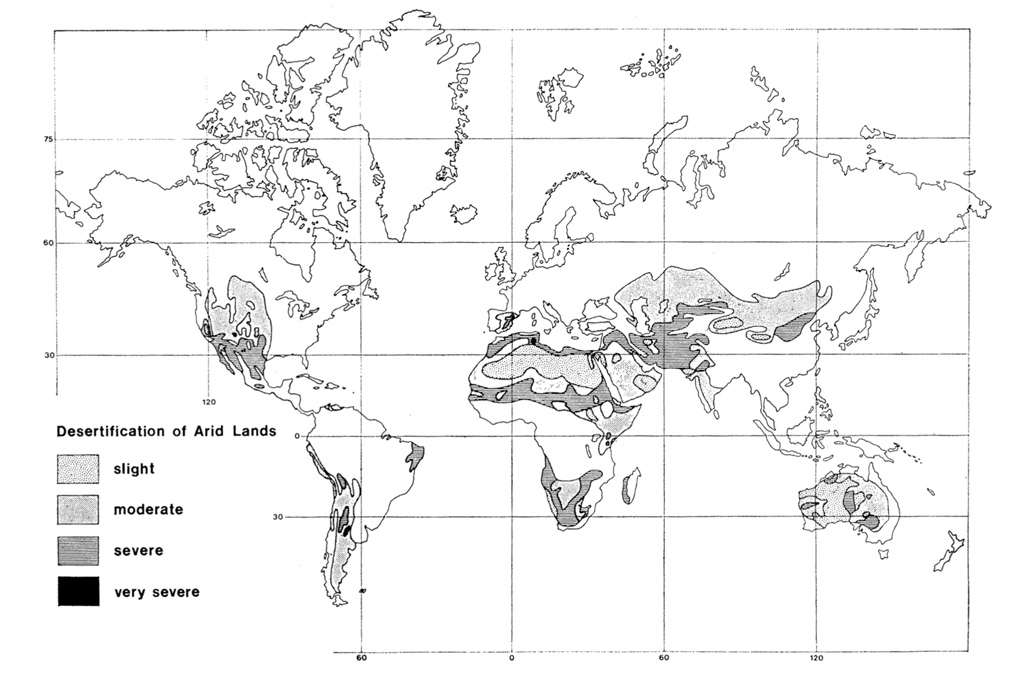
Desertification across the Earth’s land surface was first mapped in a study published in the journal Economic Geography in 1977. It noted that: “For much of the world, there is little good information on the extent of desertification in individual countries”. The map – shown below – graded areas of desertification as “slight”, “moderate”, “severe” or “very severe” based on a combination of “published information, personal experience, and consultation with colleagues”.
In 1992, the United Nations Environment Programme (UNEP) published its first “World Atlas of Desertification” (WAD). It mapped global human-caused land degradation, drawing heavily on the UNEP-funded “Global Assessment of Human-induced Soil Degradation” (GLASOD). The GLASOD project was itself based on expert judgement, with more than 250 soil and environmental scientists contributing to regional assessments that fed into its global map, which it published in 1991.
The GLASOD map, shown below, details the extent and degree of land degradation across the world. It categorised the degradation into chemical (red shading), wind (yellow), physical (purple) or water (blue).
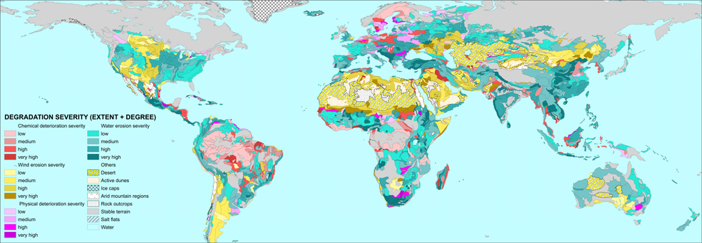
While GLASOD was also used for the second WAD, published in 1997, the map came under criticism for a lack of consistency and reproducibility. Subsequent datasets, such as the “Global Assessment of Land Degradation and Improvement” (GLADA), have benefitted from the addition of satellite data.
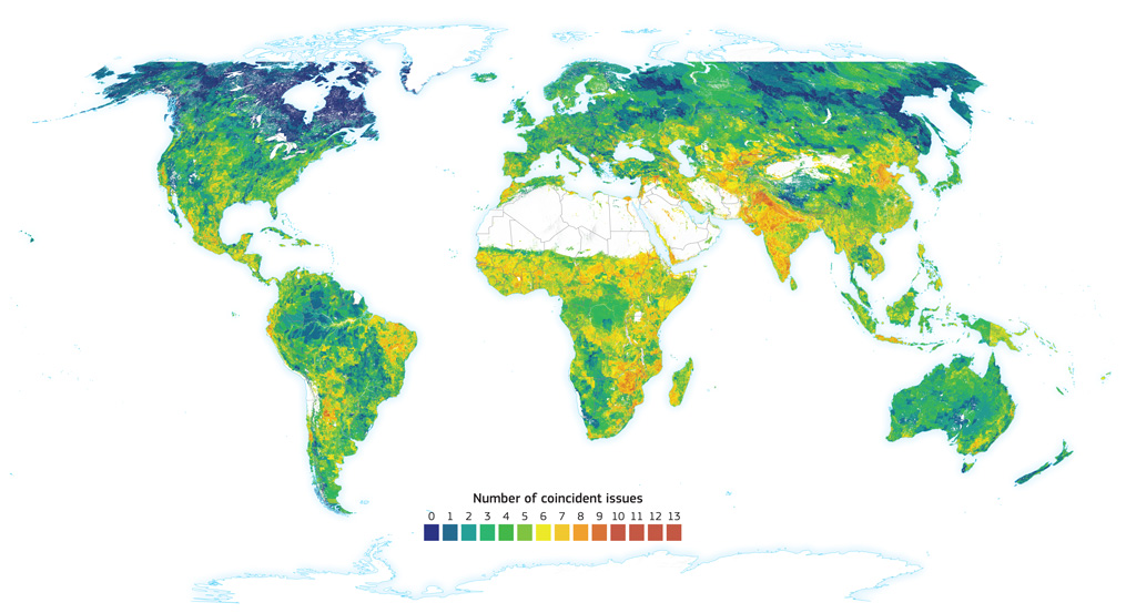
Nevertheless, by the time the third WAD – produced by the Joint Research Centre of the European Commission – came around two decades later, the authors “decided to take a different path”. As the report puts it:
“Land degradation cannot be globally mapped by a single indicator or through any arithmetic or modelled combination of variables. A single global map of land degradation cannot satisfy all views or needs.”
Instead of a single metric, the atlas considers a set of “14 variables often associated with land degradation”, such as aridity, livestock density, tree loss and decreasing land productivity.
As such, the map below – taken from the Atlas – does not show land degradation itself, but the “convergence of evidence” of where these variables coincide. The parts of the world with the most potential issues (shown by orange and red shading) – such as India, Pakistan, Zimbabwe and Mexico – are thus identified as particularly at risk from degradation.
The future
As desertification cannot be characterised by a single metric, it is also tricky to make projections for how rates of degradation could change in the future.
In addition, there are numerous socio-economic drivers that will contribute. For example, the number of people directly affected by desertification is likely to increase purely because of population growth. The population living in drylands across the world is projected to increase by 43% to four billion by 2050.
The impact of climate change on aridity is also complicated. A warmer climate is generally more able to evaporate moisture from the land surface – potentially increasing dryness in combination with hotter temperatures.
![]()
However, climate change will also affect rainfall patterns, and a warmer atmosphere can hold more water vapour, potentially increasing both average and heavy rainfall in some areas.
There is also a conceptual question of distinguishing long-term changes in the dryness of an area with the relatively short-term nature of droughts.
In general, the global area of drylands is expected to expand as the climate warms. Projections under the RCP4.5 and RCP8.5 emissions scenarios suggest drylands will increase by 11% and 23%, respectively, compared to 1961-90. This would mean drylands could make up either 50% or 56%, respectively, of the Earth’s land surface by the end of this century, up from around 38% today.
This expansion of arid regions will occur principally “over southwest North America, the northern fringe of Africa, southern Africa, and Australia”, another study says, while “major expansions of semiarid regions will occur over the north side of the Mediterranean, southern Africa, and North and South America”.
Research also shows that climate change is already increasing both the likelihood and severity of droughts around the world. This trend is likely to continue. For example, one study, using the intermediate emissions scenario “RCP4.5”, projects “large increases (up to 50%–200% in a relative sense) in frequency for future moderate and severe drought over most of the Americas, Europe, southern Africa, and Australia”.
![]()
Another study notes that climate model simulations “suggest severe and widespread droughts in the next 30–90 years over many land areas resulting from either decreased precipitation and/or increased evaporation”.
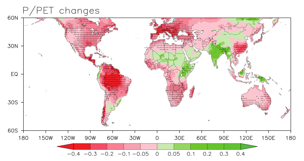
However, it should be noted that not all drylands are expected to get more arid with climate change. The map below, for example, shows the projected change for a measure of aridity (defined as the ratio of rainfall to potential evapotranspiration, PET) by 2100 under climate model simulations for RCP8.5. The areas shaded red are those expected to become drier – because PET will increase more than rainfall – while those in green are expected to become wetter. The latter includes much of the Sahel and East Africa, as well as India and parts of northern and western China.
Climate model simulations also suggest that rainfall, when it does occur, will be more intense for almost the entire world, potentially increasing the risks of soil erosion. Projections indicate that most of the world will see a 16-24% increase in heavy precipitation intensity by 2100.
Solutions
Limiting global warming is therefore one of the key ways to help put a break on desertification in future, but what other solutions exist?
The UN has designated the decade from January 2010 to December 2020 as the “United Nations decade for deserts and the fight against desertification”. The decade was to be an “opportunity to make critical changes to secure the long-term ability of drylands to provide value for humanity’s well being”.
What is very clear is that prevention is better – and much cheaper – than cure. “Once desertification has occurred it is very challenging to reverse”, says Michaelides. This is because once the “cascade of degradation processes start, they’re hard to interrupt or halt”.
Stopping desertification before it starts requires measures to “protect against soil erosion, to prevent vegetation loss, to prevent overgrazing or land mismanagement”, she explains:
“All these things require concerted efforts and policies from communities and governments to manage land and water resources at large scales. Even small scale land mismanagement can lead to degradation at larger scales, so the problem is quite complex and hard to manage.”
At the UN Conference on Sustainable Development in Rio de Janeiro in 2012, parties agreed to “strive to achieve a land-degradation neutral world in the context of sustainable development”. This concept of “land degradation neutrality” (LDN) was subsequently taken up by the UNCCD and also formally adopted as Target 15.3 of the Sustainable Development Goals by the UN General Assembly in 2015.
The idea of LDN, explained in detail in the video below, is a hierarchy of responses: first to avoid land degradation, second to minimise it where it does occur, and thirdly to offset any new degradation by restoring and rehabilitating land elsewhere. The outcome being that overall degradation comes into balance – where any new degradation is compensated with reversal of previous degradation.
“Sustainable land management” (SLM) is key to achieving the LDN target, says Dr Mariam Akhtar-Schuster, co-chair of the UNCCD science-policy interface and a review editor for the desertification chapter of the IPCC land report. She tells Carbon Brief:
“Sustainable land management practices, which are based on the local socio-economic and ecological condition of an area, help to avoid desertification in the first place but also to reduce ongoing degradation processes.”
SLM essentially means maximising the economic and social benefits of the land while also maintaining and enhancing its productivity and environmental functions. This can comprise a whole range of techniques, such as rotational grazing of livestock, boosting soil nutrients by leaving crop residues on the land after harvest, trapping sediment and nutrients that would otherwise be lost through erosion, and planting fast-growing trees to provide shelter from the wind.
But these measures can’t just be applied anywhere, notes Akhtar-Schuster:
“Because SLM has to be adapted to local circumstances there is no such thing as a one size fits all toolkit to avoid or reduce desertification. However, all these locally adapted tools will have the best effects if they are embedded in an integrated national land use planning system.”
Stringer agrees that there’s “no silver bullet” to preventing and reversing desertification. And, it’s not always the same people who invest in SLM who benefit from it, she explains:
“An example here would be land users upstream in a catchment reforesting an area and reducing soil erosion into water bodies. For those people living downstream this reduces flood risk as there is less sedimentation and could also deliver improved water quality.”
However, there is also a fairness issue if the land users upstream are paying for the new trees and those downstream are receiving the benefits at no cost, Stringer says:
“Solutions therefore need to identify who ‘wins’ and who ‘loses out’ and should incorporate strategies that compensate or minimise inequities.”
“Everyone forgets that last part about equity and fairness,” she adds. The other aspect that has also been overlooked historically is getting community buy-in on proposed solutions, says Stringer.
Research shows that using traditional knowledge can be particularly beneficial for tackling land degradation. Not least because communities living in drylands have done so successfully for generations, despite the tricky environmental conditions.
This idea is increasingly being taken on board, says Stringer – a response to “top-down interventions” that have proved “ineffective” because of a lack of community involvement.
Article information
Update: This article was updated on 03/04/2020 to clarify that the land-ocean warming contrast is a result of differences in changes in lapse rate, rather than specific heat capacity.